Llandudno railway station
| Llandudno | |
|---|---|
 Station Entrance | |
| Location | |
| Place | Llandudno |
| Local authority | Conwy County Borough |
| Grid reference | SH783819 |
| Operations | |
| Station code | LLD |
| Managed by | Transport for Wales Rail |
| Number of platforms | 3 |
| DfT category | E |
|
Live arrivals/departures, station information and onward connections from National Rail Enquiries | |
| Annual rail passenger usage* | |
| 2012/13 |
|
| 2013/14 |
|
| 2014/15 |
|
| 2015/16 |
|
| 2016/17 |
|
| History | |
| Key dates | Opened October 1858 |
| National Rail – UK railway stations | |
| * Annual estimated passenger usage based on sales of tickets in stated financial year(s) which end or originate at Llandudno from Office of Rail and Road statistics. Methodology may vary year on year. | |
|
| |
Llandudno railway station serves the seaside town of Llandudno in North Wales, and is the terminus of a 3 miles (4.8 km) long branch line from Llandudno Junction on the Crewe to Holyhead North Wales Coast Line. The station is managed by Transport for Wales Rail, who operate all trains serving it.
Llandudno Victoria station, the lower terminus of the Great Orme Tramway, is a 15-minute walk from the main station.
History

The first station and the branch line was constructed by the St. George's Harbour and Railway Company and opened on 1 October 1858.The trains at first ran to and from Conwy station until the completion of Llandudno Junction station. The line was soon absorbed by the London and North Western Railway, which in turn became part of the London, Midland and Scottish Railway in 1923. Vaughan Street in Llandudno was also laid out in 1858 as the station approach road.
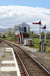
As the first station had become inadequate to cope with increasing usage, the present Llandudno station buildings and frontage together with five platforms and an extensive glass roof were erected in 1892 and the station still has the Victorian carriage road between the two principal platforms. Platforms 4 & 5 had been disused since 1978 with the tracks to the platforms being disconnected and eventually dismantled in 2012. The southernmost half of the glass roof was removed some decades ago, and the remainder was substantially cut back again in 1990. Half of the station frontage (including the former waiting and refreshment rooms) that had been disused for years was demolished in May 2009. The station retains its semaphore signalling and manual signal box.
Facilities
In recent years, plans were unveiled for the transformation of the station into a Transport Interchange, which would involve the demolition of the disused part of the frontage and the introduction of new passenger facilities. Following the provision of funding, reconstruction began in 2013 and the £5.2 million scheme was completed in the summer of 2014.[1] The work included a 130 space car park (on the site of the former Platforms 4 & 5), a glazed concourse, a bus interchange, new taxi rank, and a shop/cafe. There are also a new entrance and improvements to the platforms.
The ticket office is staffed part-time (08:30-15:00 weekdays, 09:15-15:45 Saturdays, 10:00-17:30 Sundays in July and August only). A self-service ticket machine is provided for use outside these times and for collecting advance purchase tickets. There are also toilets and a waiting room on the concourse. Train running information is provided by digital information screens, posters and automated announcements. Step-free access is available to all platforms.[2]
Services
- Transport for Wales Rail provides an hourly service to Manchester Piccadilly via Colwyn Bay, Rhyl, Prestatyn, Flint, Chester and Warrington. Two daily services on this route (including the last train each evening) run to Crewe rather than Manchester and certain trains are extended through to Manchester Airport.[3]
- Transport for Wales Rail also operates an hourly shuttle (with some afternoon gaps) to Llandudno Junction which connects with services to Bangor & Holyhead and for services to Birmingham New Street, London and South Wales. They also operate one weekday direct service from Llandudno to Cardiff Central via Wrexham General without any change being required at Llandudno Junction (and one the other way, plus two more from Birmingham International).
- Transport for Wales Rail provides four trains per day along the Conwy Valley Line serving Llanrwst, Betws-y-Coed and Blaenau Ffestiniog.[4]
- On summer Sundays (May to September in the current timetable) TfW Rail operate a (roughly) half-hourly shuttle service to Llandudno Junction until early evening. In addition, two trains a day run down the Conwy Valley Line to Blaenau Ffestiniog.
- Virgin Trains West Coast used to run a direct afternoon service to London Euston, but this service was discontinued at the December 2008 timetable change - it instead now terminates at Chester.
| Preceding station | Following station | |||
|---|---|---|---|---|
| Deganwy | Transport for Wales Rail Conwy Valley Line |
Terminus | ||
| Transport for Wales Rail North Wales Coast Line |
||||
Notes
- ↑ "Llandudno's new £5.2m railway station"North Wales Daily Post article 23 July 2014; Retrieved 13 January 2017
- ↑ Llandudno station facilities National Rail Enquiries
- ↑ Table 81 National Rail timetable, May 2017
- ↑ GB NRT May 2017 Edition, Table 102
Further reading
- Mitchell, Vic; Smith, Keith (2010). Bala to Llandudno. West Sussex: Middleton Press. figs. 114-120. ISBN 9781906008871. OCLC 668198724.
- Mitchell, Vic; Smith, Keith (2012). Rhyl to Bangor. West Sussex: Middleton Press. figs. 64-70. ISBN 9781908174154. OCLC 859594415.
- Allen, David (21 October – 3 November 1998). "Seaside signalling in North Wales". RAIL. No. 342. EMAP Apex Publications. pp. 40–42. ISSN 0953-4563. OCLC 49953699.
External links
| Wikimedia Commons has media related to Llandudno railway station. |
- Train times and station information for Llandudno railway station from National Rail
- Llandudno and North Wales Train Services 1947 and 2003
- Virgin Trains restore through London to Llandudno Service
Coordinates: 53°19′16″N 3°49′37″W / 53.321°N 3.827°W
Railway stations in Conwy County Borough | ||
|---|---|---|
| Conwy Valley line | 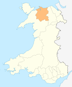 | |
| Great Orme Tramway | ||
| North Wales Coast Line | ||
| ||