Little Osage River
| Little Osage River | |
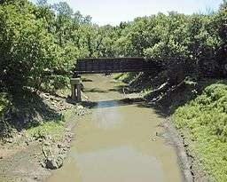 The Little Osage River near Horton, Missouri | |
| Country | United States |
|---|---|
| State | Kansas, Missouri |
| Tributaries | |
| - right | Limestone Creek, Marmaton River |
| Source confluence | |
| - location | Allen County, Kansas |
| - elevation | 943 ft (287 m) |
| - coordinates | 38°01′32″N 95°05′23″W / 38.02556°N 95.08972°W |
| Mouth | Osage River |
| - location | Vernon County, Missouri |
| - elevation | 722 ft (220 m) |
| - coordinates | 38°01′39″N 94°14′39″W / 38.02750°N 94.24417°WCoordinates: 38°01′39″N 94°14′39″W / 38.02750°N 94.24417°W [1] |
| Length | 88 mi (142 km) |
| Discharge | for USGS 0691700 at Horton, Missouri[2] |
| - average | 369 cu ft/s (10 m3/s) |
| - max | 43,700 cu ft/s (1,237 m3/s) |
| - min | 0 cu ft/s (0 m3/s) |
| Watersheds | Little Osage-Osage-Missouri-Mississippi |
 Map of the Osage River watershed showing the Little Osage River | |
The Little Osage River is an 88-mile-long (142 km)[3] tributary of the Osage River in eastern Kansas and western Missouri in the United States. Via the Osage and Missouri rivers, it is part of the watershed of the Mississippi River.
The name was derived from the Osage Nation.[4]
Course
The Little Osage rises in Kansas in northeastern Allen County at the confluence of the North and Middle Forks. The stream flows southeast into Bourbon County where the South Fork joins the stream and the stream turns and flows to the east. The stream turns sharply south and crosses Kansas 65 to the east of Xenia. The stream meanders eastward passing just north of Fulton crossing under U.S. Route 69 and enters southwestern Vernon County, Missouri. In Vernon County the stream passes just north of Stotesbury and on to pass under U.S. Route 71 north of Horton and through the Four Rivers Conservation Area and is joined by the Marmaton River. On the boundary of Vernon and Bates counties, the Little Osage joins the Marais des Cygnes River to form the Osage River, 6 miles (10 km) west of Schell City.[5] The area to the east of the Marmaton River confluence are within the Harry S Truman Reservoir flooded area.[6]
See also
References
- ↑ "Little Osage River". Geographic Names Information System. United States Geological Survey. Retrieved 2015-11-05.
- ↑ "Water-Data Report 2012 - 0691700 Little Osage River at Horton, MO" (PDF). U.S. Geological Survey. Retrieved 2015-11-05.
- ↑ U.S. Geological Survey. National Hydrography Dataset high-resolution flowline data. The National Map Archived 2012-04-05 at WebCite, accessed May 31, 2011
- ↑ Lyman, Clifford (16 July 1976). "Names' Past Cloudy". Fort Scott Tribune. pp. 13B. Retrieved 22 April 2015.
- ↑ Blue Mound, Mapleton, Xenia, Devon, Mantey, Prescott and Hammond (Kansas) and Richards, Metz, Horton, Rich Hill and Papinville (Missouri) 7.5 Minute Topographic Quadrangles, USGS, various dates
- ↑ Nevada, MO-KS (1991) and Butler, MO-KS (1981), 1:100,000 scale Topographic Maps. USGS
External links