Litlmolla
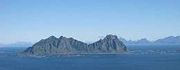 View of Litlmolla, seen from near Svolvær | |
 Location in Nordland | |
| Geography | |
|---|---|
| Location | Nordland, Norway |
| Coordinates | 68°11′55″N 14°44′54″E / 68.1985°N 14.7484°ECoordinates: 68°11′55″N 14°44′54″E / 68.1985°N 14.7484°E |
| Area | 9.7 km2 (3.7 sq mi) |
| Length | 4.0 km (2.49 mi) |
| Width | 3.6 km (2.24 mi) |
| Highest elevation | 543 m (1,781 ft) |
| Highest point | Nonstinden |
| Administration | |
|
Norway | |
| County | Nordland |
| Municipality | Vågan |
Litlmolla,[1] is an island in the municipality of Vågan in Nordland county, Norway. The island lies east of Svolvær in the Vestfjorden. The island is located south of the large island of Austvågøya and Stormolla and northeast of Skrova. It has an area of about 10 square kilometres (3.9 sq mi). The highest point on the island is the 543-metre (1,781 ft) tall Nonstinden. The island was formerly inhabited, but has long since been abandoned.[2][1]
References
- 1 2 Store norske leksikon. "Molla" (in Norwegian). Retrieved 2012-07-13.
- ↑ "Bent Svinnung's site about Keila on Litlmolla" (in Norwegian). Retrieved 2012-07-13.
This article is issued from
Wikipedia.
The text is licensed under Creative Commons - Attribution - Sharealike.
Additional terms may apply for the media files.