List of cities, towns and villages in the Solomon Islands

This is a list of populated places in the Solomon Islands.

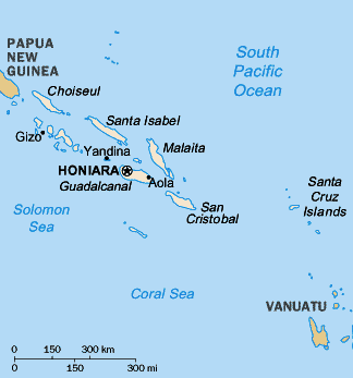
A map of the Solomon Islands.
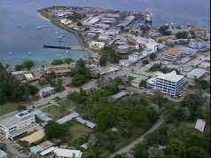
The capital Honiara.

Populated places

City, town or villageCoordinatesCensus 1999IslandProvince
Auki8°46′S 160°42′E / 8.76°S 160.70°E / -8.76; 160.70 (Auki)4,022MalaitaMalaita Province
Buala8°10′S 159°37′E / 8.16°S 159.62°E / -8.16; 159.62 (Buala)2,438Santa Isabel IslandIsabel Province
Gizo (Ghizo)8°06′S 156°51′E / 8.10°S 156.85°E / -8.10; 156.85 (Gizo)5,323Ghizo IslandWestern Province
Honiara9°26′S 159°55′E / 9.43°S 159.91°E / -9.43; 159.91 (Honiara)49,107GuadalcanalGuadalcanal Province
Kamaosi8°28′39.49″S 159°48′29.37″E / 8.4776361°S 159.8081583°E / -8.4776361; 159.8081583 (Kamaosi)?Santa Isabel IslandIsabel Province
Kirakira (Kaokaona)10°26′S 161°53′E / 10.44°S 161.88°E / -10.44; 161.88 (Kirakira)979Makira (San Cristobal)Makira-Ulawa Province
Lata (Santa Cruz)10°43′S 165°50′E / 10.71°S 165.83°E / -10.71; 165.83 (Lata)n/aNendo IslandTemotu Province
Maniora10°16′S 161°31′E / 10.26°S 161.52°E / -10.26; 161.52 (Maniora)100Makira (San Cristobal)Makira-Ulawa Province
Munda8°20′S 157°16′E / 8.33°S 157.27°E / -8.33; 157.27 (Tigoa)n/aNew GeorgiaWestern Province
Noro8°13′S 157°13′E / 8.22°S 157.22°E / -8.22; 157.22 (Noro)3,482New GeorgiaWestern Province
Taro Island6°43′S 156°26′E / 6.72°S 156.43°E / -6.72; 156.43 (Taro Island)440Taro IslandChoiseul Province
Tigoa (Tinggoa)11°32′S 160°02′E / 11.54°S 160.03°E / -11.54; 160.03 (Tigoa)n/aRennell Island (Mungava)Rennell and Bellona Province
Tulagi (Tulaghi)9°05′S 160°09′E / 9.09°S 160.15°E / -9.09; 160.15 (Tulagi)1,333TulagiCentral Province

References

    This article is issued from Wikipedia. The text is licensed under Creative Commons - Attribution - Sharealike. Additional terms may apply for the media files.