Provinces of Solomon Islands
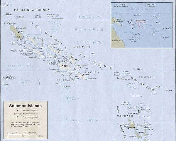

Solomon Islands is divided into nine provinces. The national capital, Honiara, on the island of Guadalcanal, is separately governed as the islands' Capital Territory.
History
Under the British Solomon Islands Protectorate, there were initially 12 administrative districts: Choiseul, Eastern Solomons, Gizo, Guadalcanal, Lord Howe, Malaita, Nggela and Savo, Rennell and Bellona Islands, Santa Cruz, Shortlands, Sikaiana (Stewart), and Ysabel and Cape Marsh. The administrative centre was in Tulagi.
After World War II, the protectorate was reorganised into four districts, namely Central, Western, Eastern, and Malaita, which were then further subdivided into councils. The administrative centre was moved from Tulagi to Honiara.
At its independence in 1978, the protectorate became the sovereign state of Solomon Islands. Honiara continued to function as the capital of the sovereign nation, and the inherited districts and councils remained until 1981, when the nation was reorganised into seven provinces by splitting some of the districts into provinces: the Central District was split into Central, Guadalcanal, and Isabel provinces, while the Eastern District was split into Makira-Ulawa and Temotu provinces. The other two districts, Western and Malaita, were also designated as provinces. These new provinces corresponded to the councils of the districts before 1981.
In 1983, the 22 square-kilometer Honiara was split from Guadalcanal Province and became a separately-governed capital territory. The city remains as the capital of Guadalcanal Province.
In 1995, Choiseul Province was split from Western Province, and Rennell and Bellona Province was split from Central Province, resulting in the nine provinces of today.
Population
The population census data is from the 1999 census; the 2009 population estimates are those provided by the Solomon Islands National Statistics Office. They show that the population has increased in the past decade for most of the provinces, especially the more urban ones, as urbanisation increases.
The figures for Guadalcanal Province do not include the separately-administered Capital Territory of Honiara; if included, that province would have had a total population of 109,382 in 1999, when it was the second largest province by population; by 2009, the combined estimate for Guadalcanal and the Capital Territory would be 157,745, which would make it the most populous province.
Provinces
| # | Province | Capital | Premier | Area (km²) | Population census 1999 | Population per km² (2009) | Population census 2009 |
|---|---|---|---|---|---|---|---|
| 1 | Tulagi | Patrick Vasuni | 615 | 21,577 | 42.4 | 26,051 | |
| 2 | Taro Island | Jackson Kiloe | 3,837 | 20,008 | 6.9 | 26,371 | |
| 3 | Honiara | Anthony Veke | 5,336 | 60,275 | 17.5 | 93,613 | |
| 4 | Buala | James Habu | 4,136 | 20,421 | 6.3 | 26,158 | |
| 5 | Kirakira | Stanley Siapu | 3,188 | 31,006 | 12.7 | 40,419 | |
| 6 | Auki | Peter Ramohia | 4,225 | 122,620 | 32.6 | 137,596 | |
| 7 | Tigoa | Collin Suatai Singamoana | 671 | 2,377 | 4.5 | 3,041 | |
| 8 | Lata | David Maina | 895 | 18,912 | 23.9 | 21,362 | |
| 9 | Gizo | George Solingi Lilo | 5,475 | 62,739 | 14.0 | 76,649 | |
| - | Honiara | Mua (Mayor) | 22 | 49,107 | 2,936.8 | 64,609 | |
| Solomon Islands | Honiara | - | 28,400 | 409,042 | 14.7 | 515,870 |
[1] excluding the Capital Territory of Honiara
See also
References
| ||
Solomon Islands articles | |||||
|---|---|---|---|---|---|
| History |  | ||||
| Geography |
| ||||
| Politics | |||||
| Economy | |||||
| Society |
| ||||
| |||||
Articles on first-level administrative divisions of Oceanian countries | |
|---|---|