List of Northern Cordilleran volcanoes

Map of the Northern Cordilleran Volcanic Province and location of nearby fault zones. The volcanoes fall into the region between the two faults.
Minor and major volcanoes of the Northern Cordilleran Volcanic Province, including the Queen Charlotte, Denali and Tintina fault zones

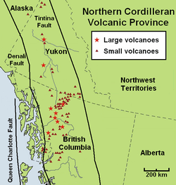
The geography of northwestern British Columbia and Yukon, Canada is dominated by volcanoes of the Northern Cordilleran Volcanic Province formed due to continental rifting of the North American Plate. It is the most active volcanic region in Canada.[1] Some of the volcanoes are notable for their eruptions, for instance, Tseax Cone for its catastrophic eruption estimated to have occurred in the 18th century which was responsible for the death of at least 2,000 Nisga'a people from poisonous volcanic gases,[2] the Mount Edziza volcanic complex for at least 20 eruptions throughout the past 10,000 years, and The Volcano (also known as Lava Fork volcano) for the most recent eruption in Canada during 1904.[3] The majority of volcanoes in the Northern Cordilleran Volcanic Province lie in Canada while a very small portion of the volcanic province lies in the U.S. state of Alaska.

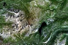
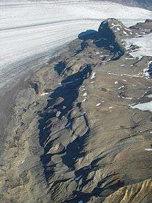
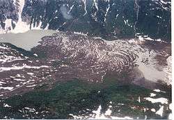
Volcanoes of the Northern Cordilleran Volcanic Province are a part of the Pacific Ring of Fire. The largest and most persistent volcanoes are the Mount Edziza volcanic complex and Level Mountain in northwestern British Columbia which have had volcanic activity for millions of years. In the past 7.5 million years, the Mount Edziza volcanic complex has had five phases of volcanic activity while Level Mountain north of Edziza has had three phases of volcanic activity in the past 14.9 million years.[4] The 1,000 km2 (390 sq mi) Mount Edziza volcanic complex has been made into a provincial park since 1972 to protect its volcanic landscape. The 102 Northern Cordilleran volcanoes in the list below are grouped into their political regions in north-south order.

Scope

There is no single standard definition for a volcano. It can be defined from individual vents, volcanic edifices or volcanic fields. Interior of ancient volcanoes may have been eroded, creating a new subsurface magma chamber as a separate volcano. Many contemporary volcanoes rise as young parasitic cones from flank vents or at a central crater. Some volcanoes are grouped into one volcano name, for instance, the Mount Edziza volcanic complex, although individual vents are named by local people. The status of a volcano, either active, dormant or extinct, cannot be defined precisely. An indication of a volcano is determined by either its historical records, potassium-argon dating, radiocarbon dating, or geothermal activities.

The primary source of the list below is taken from the Geological Survey of Canada website, compiled by the Earth Sciences Sector of Natural Resources Canada, in which Northern Cordilleran volcanoes in the past 66.4 million years are listed.[5] The Geological Survey of Canada use a catalogue of volcanoes grouped by volcano fields, lava fields and mountain ranges.[5] The Geological Survey of Canada list is the most complete list of volcanoes in the Northern Cordilleran Volcanic Province, but work of understanding the frequency and eruption characteristics at volcanoes in Canada is a slow process.[6] This is because most of Canada's dormant and potentially active volcanoes are located in isolated jagged regions, very few scientists study Canadian volcanoes and the provision of money in the Canadian government is limited.[6] Because of these issues, scientists that study Canada's volcanoes have a basic understanding of Canada's volcanic heritage and how it might impact people in the future.[6] Therefore, instead of using the dates of recorded eruptions, the Geological Survey of Canada mostly uses geological epochs for estimating when a volcano last erupted. Geological epoches include the Cenozoic (66.4 million years ago to present)[7] and its subdivisions Miocene (23.7 to 5.3 million years ago),[8] Pliocene (5.3 to 1.6 million years ago),[9] Quaternary (1.6 million years ago to present),[10] Pleistocene (1.6 to 0.01 million years ago)[11] and Holocene (0.01 million years ago to present).[12]

Political groups

Alaska

The northernmost portion of the Northern Cordilleran Volcanic Province extends just across the Alaska-Yukon border into the Southeast Fairbanks Census Area of eastcentral Alaska. Here, a single cinder cone, dated at 177,000 years old occurs within the metamorphic and granitic composed upland of the Yukon-Tanana Terrane.[4][13] Prindle Volcano is approximately 31 km (19 mi) west of the Alaska-Yukon border.[4]

Volcanoes
Name Type Last eruption Location
Prindle VolcanoCinder conePleistocene63°43′N 141°37′W / 63.72°N 141.62°W / 63.72; -141.62

Yukon

Jagged landscape of mountains with a small lake in the near middle.
Alligator Lake (right-middle) and the Alligator Lake volcanic field

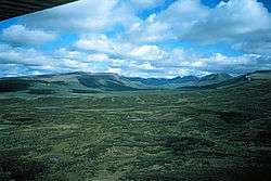
The central portion of the Northern Cordilleran Volcanic Province extends through Yukon where very few Northern Cordilleran volcanoes exist. Near the junction of the Yukon and Pelly rivers in central Yukon lies the Fort Selkirk Volcanic Field.[14] It is the northernmost Holocene age volcanic field in Canada, consisting of a sequence of valley-filling basalt and basanite lava flows.[14] Further south near the capital city of Whitehorse, a group of volcanoes and lava flows were constructed near Alligator Lake possibly in the past 10,000 years.[15]

Volcanoes
Name Type Last eruption Location
Volcano MountainCinder coneHolocene62°56′N 137°22′W / 62.93°N 137.37°W
Fort Selkirk VentCinder conePleistocene62°46′N 137°25′W / 62.77°N 137.42°W
Ne Ch'e DdhawaCinder conePleistocene62°28′N 137°14′W / 62.47°N 137.24°W
Ibex MountainCinder conePleistocene60°32′N 135°31′W / 60.53°N 135.52°W
Watson Lake ConeCinder conePleistocene60°00′N 129°00′W / 60.00°N 129.00°W
Erupted products
Name Type Age Location
Clinton CreekLava flowPliocene64°24′N 140°38′W / 64.40°N 140.63°W
Forty MileUnknownMiocene64°23′N 140°30′W / 64.38°N 140.5°W
Moose CreekUnknownCenozoic64°10′N 140°55′W / 64.16°N 140.91°W
Sixty MileUnknownMiocene64°03′N 140°44′W / 64.05°N 140.74°W
Rosebud CreekLava flowPliocene63°15′N 138°14′W / 63.25°N 138.24°W
Yukon RiverLava flowPleistocene62°50′N 137°42′W / 62.83°N 137.7°W
Holbrook CreekLava flowPleistocene62°48′N 137°59′W / 62.80°N 137.98°W
MushroomLava flowPliocene62°48′N 137°27′W / 62.80°N 137.45°W
Pelly FormationLava flowPleistocene62°48′N 137°30′W / 62.80°N 137.5°W
Wolverine FormationLava flowPleistocene62°42′N 137°24′W / 62.70°N 137.4°W
MintoLava flowHolocene62°36′N 137°12′W / 62.60°N 137.2°W
Miles Canyon BasaltsLava flowMiocene60°24′N 135°00′W / 60.40°N 135.00°W

British Columbia

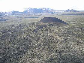
Over half of the Northern Cordilleran volcanoes are located in northwestern British Columbia. This portion is where the most recent eruptions in Canada and of the Northern Cordilleran Volcanic Province have occurred, including the catastrophic 18th century eruption of Tseax Cone and the 1904 eruption of The Volcano.[3][16]

The Northern Cordilleran volcanoes of British Columbia comprises shield volcanoes, stratovolcanoes, subglacial volcanoes, lava domes and a large number of small cinder cones and associated lava plains.[4] The Northern Cordilleran volcanoes of northwestern British Columbia are disposed along short, northerly trending segments which are unmistakably involved with north-trending rift structures including synvolcanic grabens and grabens with one major fault line along only one of the boundaries (half-grabens) similar to those associated with the East African Rift, which extends from the Afar Triple Junction southward across eastern Africa.[4]

Volcanoes
Name Type Last eruption Location
Volcanic Creek ConeCinder coneHolocene59°45′N 133°27′W / 59.75°N 133.45°W
Cracker Creek ConeCinder coneQuaternary59°42′N 133°17′W / 59.70°N 133.29°W
Ruby MountainCinder coneHistoric59°41′N 123°20′W / 59.68°N 123.33°W
Iverson Creek VolcanoOutcropPleistocene59°30′N 130°17′W / 59.50°N 130.28°W
Toozaza PeakTuyaPleistocene59°30′N 130°18′W / 59.50°N 130.3°W
Klinkit Lake PeakTuyaPleistocene59°29′N 131°00′W / 59.49°N 131.00°W
Klinkit Creek PeakTuyaPleistocene59°28′N 131°17′W / 59.47°N 131.28°W
Gabrielse ConeCinder coneHolocene59°26′N 130°28′W / 59.44°N 130.46°W
Mount SanfordOutcropCenozoic59°25′N 132°45′W / 59.42°N 132.75°W
Cottonwood PeakOutcropPleistocene59°24′N 130°15′W / 59.40°N 130.25°W
Ash MountainSubglacial moundPleistocene59°16′N 130°30′W / 59.27°N 130.5°W
Chakatah Creek PeakSubglacial moundPleistocene59°15′N 131°02′W / 59.25°N 131.03°W
Caribou TuyaSubglacial moundPleistocene59°14′N 130°34′W / 59.24°N 130.56°W
South TuyaSubglacial moundPleistocene59°13′N 130°30′W / 59.21°N 130.5°W
Mathews TuyaSubglacial moundPleistocene59°12′N 130°26′W / 59.20°N 130.43°W
Tuya ButteTuyaPleistocene59°08′N 130°33′W / 59.13°N 130.55°W
Isspah ButteTuyaPleistocene59°04′N 131°19′W / 59.07°N 131.32°W
Mount JosephineSubglacial moundPleistocene59°36′N 130°42′W / 59.6°N 130.7°W
Chikoida MountainOutcropCenozoic59°12′N 133°24′W / 59.2°N 133.4°W
Meehaz MountainSubglacial moundPleistocene59°00′N 131°26′W / 59.00°N 131.44°W
Kawdy MountainSubglacial moundPleistocene58°53′N 131°14′W / 58.88°N 131.23°W
Nuthinaw MountainSubglacial moundPleistocene58°47′N 131°04′W / 58.79°N 131.06°W
Tutsingale MountainSubglacial moundPleistocene58°47′N 130°52′W / 58.78°N 130.87°W
Dark MountainSubglacial moundPleistocene58°38′N 129°21′W / 58.64°N 129.35°W
Heart PeaksShield volcanoPleistocene58°36′N 131°58′W / 58.60°N 131.97°W
Swinton Creek VolcanoOutcropPleistocene58°34′N 129°50′W / 58.57°N 129.84°W
Little Eagle ConeSubglacial moundPleistocene58°31′N 129°43′W / 58.52°N 129.71°W
Meszah PeakOutcropPleistocene58°29′N 131°26′W / 58.48°N 131.43°W
Dome MountainSubglacial moundPleistocene58°27′N 129°35′W / 58.45°N 129.59°W
Level MountainShield volcanoPleistocene58°25′N 131°21′W / 58.42°N 131.35°W
Enid Creek ConeSubglacial moundPleistocene58°23′N 129°31′W / 58.38°N 129.52°W
Kana ConeCinder coneHolocene57°54′N 130°37′W / 57.90°N 130.62°W
Sidas ConeCinder coneHolocene57°52′N 130°38′W / 57.87°N 130.63°W
Castle RockVolcanic plugPleistocene57°50′N 131°09′W / 57.84°N 131.15°W
Eve ConeCinder coneHolocene57°49′N 130°40′W / 57.82°N 130.67°W
Triplex ConeCinder coneHolocene57°48′N 130°37′W / 57.80°N 130.62°W
Twin ConeCinder coneHolocene57°48′N 130°32′W / 57.80°N 130.53°W
Sleet ConeCinder coneHolocene57°47′N 130°33′W / 57.78°N 130.55°W
Williams ConeCinder coneHolocene57°47′N 130°36′W / 57.78°N 130.6°W
Klastline ConeCinder conePleistocene57°47′N 130°30′W / 57.78°N 130.5°W
Tsekone RidgeSubglacial moundPleistocene57°46′N 130°41′W / 57.77°N 130.69°W
Storm ConeCinder coneHolocene57°46′N 130°38′W / 57.77°N 130.63°W
Moraine ConeCinder coneHolocene57°46′N 130°37′W / 57.77°N 130.62°W
Glacier DomeLava domePleistocene57°46′N 130°35′W / 57.77°N 130.58°W
The PyramidLava domePleistocene57°46′N 130°34′W / 57.77°N 130.57°W
Pillow RidgeSubglacial moundPleistocene57°46′N 130°38′W / 57.76°N 130.64°W
Sphinx DomeLava domePleistocene57°45′N 130°35′W / 57.75°N 130.58°W
Cinder CliffCinder coneHolocene57°45′N 130°34′W / 57.75°N 130.57°W
Triangle DomeLava domePleistocene57°43′N 130°39′W / 57.72°N 130.65°W
Mount EdzizaStratovolcanoPleistocene57°43′N 130°38′W / 57.72°N 130.63°W
Nanook DomeLava domePleistocene57°43′N 130°36′W / 57.72°N 130.6°W
Ice PeakStratovolcanoHolocene57°42′N 130°38′W / 57.70°N 130.63°W
Icefall ConeCinder coneHolocene57°42′N 130°36′W / 57.70°N 130.6°W
Tennena ConeSubglacial moundHolocene57°41′N 130°40′W / 57.68°N 130.67°W
Ridge ConeCinder conePleistocene57°41′N 130°37′W / 57.68°N 130.62°W
The NeckVolcanic plugPleistocene57°40′N 130°35′W / 57.66°N 130.59°W
Cocoa CraterCinder coneHolocene57°39′N 130°42′W / 57.65°N 130.7°W
Pharaoh DomeLava domePleistocene57°39′N 130°36′W / 57.65°N 130.6°W
Coffee CraterCinder coneHolocene57°38′N 130°40′W / 57.63°N 130.67°W
The SaucerCinder coneHolocene57°38′N 130°38′W / 57.63°N 130.63°W
Keda ConeCinder coneHolocene57°36′N 130°41′W / 57.60°N 130.68°W
Sezill VolcanoLava domeMiocene57°35′N 130°37′W / 57.59°N 130.62°W
Camp HillCinder coneHolocene57°35′N 130°47′W / 57.58°N 130.78°W
Walkout Creek ConeCinder coneHolocene57°35′N 130°45′W / 57.58°N 130.75°W
IGC CentreLava domeMiocene57°34′N 130°37′W / 57.56°N 130.62°W
Cartoona RidgeLava domeMiocene57°34′N 130°34′W / 57.56°N 130.57°W
Tadeda CentreLava domeMiocene57°32′N 130°37′W / 57.54°N 130.61°W
Cache HillCinder coneHolocene57°32′N 130°40′W / 57.53°N 130.67°W
Armadillo PeakStratovolcanoMiocene57°32′N 130°33′W / 57.53°N 130.55°W
Mess Lake ConeCinder coneHolocene57°28′N 130°45′W / 57.47°N 130.75°W
Little IskutOutcropPliocene57°28′N 130°33′W / 57.47°N 130.55°W
The Ash PitVolcanic craterHolocene57°27′N 130°47′W / 57.45°N 130.78°W
Spectrum RangeShield volcanoHolocene57°26′N 130°41′W / 57.43°N 130.68°W
Outcast HillCinder conePleistocene57°24′N 130°46′W / 57.40°N 130.77°W
Maitland VolcanoShield volcanoPliocene57°24′N 129°42′W / 57.40°N 129.7°W
Exile HillCinder conePliocene57°23′N 130°49′W / 57.38°N 130.82°W
Spectrum DomeLava domePliocene57°23′N 130°41′W / 57.38°N 130.68°W
Yeda PeakLava domePliocene57°23′N 130°41′W / 57.38°N 130.68°W
Tadekho HillSubglacial moundPleistocene57°21′N 130°47′W / 57.35°N 130.78°W
Nahta ConeCinder coneHolocene57°19′N 130°49′W / 57.32°N 130.82°W
Wetalth RidgeSubglacial moundPleistocene57°19′N 130°47′W / 57.32°N 130.78°W
Source HillCinder conePleistocene57°17′N 130°49′W / 57.28°N 130.82°W
Thaw HillCinder conePleistocene57°17′N 130°49′W / 57.28°N 130.82°W
Little Bear MountainTuyaPleistocene56°48′N 131°18′W / 56.80°N 131.3°W
Hoodoo MountainStratovolcanoHolocene56°47′N 131°17′W / 56.78°N 131.28°W
Tom MacKay Creek ConeSubglacial moundPleistocene56°43′N 130°34′W / 56.71°N 130.56°W
Iskut Canyon ConeCinder coneHolocene56°43′N 130°36′W / 56.71°N 130.6°W
Snippaker Creek ConeCinder coneHolocene56°38′N 130°52′W / 56.63°N 130.87°W
Cinder MountainSubglacial moundPleistocene56°34′N 130°37′W / 56.57°N 130.61°W
Cone Glacier VolcanoCinder coneHolocene56°34′N 130°40′W / 56.56°N 130.66°W
King Creek ConeSubglacial moundPleistocene56°29′N 130°40′W / 56.49°N 130.66°W
The VolcanoCinder coneHistoric56°25′N 130°51′W / 56.42°N 130.85°W
Second Canyon ConeCinder coneHolocene56°25′N 130°43′W / 56.41°N 130.72°W
The ThumbVolcanic plugPleistocene56°10′N 126°42′W / 56.16°N 126.7°W
Tseax ConeCinder coneHistoric55°07′N 128°54′W / 55.12°N 128.9°W
Crow LagoonCinder conePleistocene54°42′N 130°14′W / 54.7°N 130.23°W
Erupted products
Name Type Age Location
Anderson BayLava flowMiocene59°18′N 133°45′W / 59.3°N 133.75°W
Desolation Lava FieldLava fieldHolocene57°49′N 130°37′W / 57.82°N 130.62°W
Snowshoe Lava FieldLava fieldHolocene57°39′N 130°40′W / 57.65°N 130.67°W
Sheep Track PumicePumice depositHolocene57°38′N 130°40′W / 57.64°N 130.67°W
Mess Lake Lava FieldLava fieldHolocene57°28′N 130°45′W / 57.47°N 130.75°W
A large open mountain covered with ice and snow rising over the surrounding landscape.
Northwestern flank of Mount Edziza
Landscape of a flat plain with two groups of mountains.
Satellite image of Level Mountain (middle) and Heart Peaks (upper-left corner)
Landscape of a mountain range.
Level Mountain with extensive elevated plateau in the foreground
Rock exposed near glacial ice.
Hoodoo Glacier and lava flows on the flanks of Hoodoo Mountain
Open area of lava beds right by a road.
Nass valley lava beds formed by eruptions of the Tseax Cone
A valley filled with rugged rock in a mountainous area.
Recently extruded basaltic lava at the Blue River

See also

References

  1. "Stikine volcanic belt". Catalogue of Canadian volcanoes. Geological Survey of Canada. 2008-02-13. Archived from the original on 2009-06-08. Retrieved 2009-06-22.
  2. "Tseax Cone". Catalogue of Canadian volcanoes. Geological Survey of Canada. 2009-03-10. Retrieved 2009-06-22.
  3. 1 2 "Lava Forks Provincial Park". BC Parks. Retrieved 2009-06-24.
  4. 1 2 3 4 5 Wood, Charles A.; Kienle, Jürgen (2001). Volcanoes of North America: United States and Canada. Cambridge, England: Cambridge University Press. pp. 109, 114, 121, 122, 123, 124, 125. ISBN 978-0-521-43811-7. OCLC 27910629.
  5. 1 2 "Catalogue of Canadian volcanoes". Geological Survey of Canada. 2008-02-13. Archived from the original on 2009-06-08. Retrieved 2009-06-21.
  6. 1 2 3 "Volcanoes". Natural Resources Canada. 2007-09-05. Archived from the original on 2009-02-17. Retrieved 2009-06-21.
  7. "Chikoida Mountain". Catalogue of Canadian volcanoes. Geological Survey of Canada. 2009-03-10. Archived from the original on 2011-06-04. Retrieved 2009-06-22.
  8. "Armadillo Peak". Catalogue of Canadian volcanoes. Geological Survey of Canada. 2009-03-10. Archived from the original on 2011-07-16. Retrieved 2009-06-22.
  9. "Maitland Volcano". Catalogue of Canadian volcanoes. Geological Survey of Canada. 2009-03-10. Retrieved 2009-06-22.
  10. "Cracker Creek cone". Catalogue of Canadian volcanoes. Geological Survey of Canada. 2009-03-10. Retrieved 2009-06-22.
  11. "Kawdy Mountain". Catalogue of Canadian volcanoes. Geological Survey of Canada. 2009-03-10. Retrieved 2009-06-22.
  12. "Hoodoo Mountain". Catalogue of Canadian volcanoes. Geological Survey of Canada. 2009-03-10. Retrieved 2009-06-22.
  13. "Map of Canadian volcanoes". Volcanoes of Canada. Geological Survey of Canada. 2008-02-13. Archived from the original on 2006-07-14. Retrieved 2009-06-22.
  14. 1 2 "Fort Selkirk". Global Volcanism Program. Smithsonian Institution. Retrieved 2009-06-24.
  15. "Alligator Lake". Global Volcanism Program. Smithsonian Institution. Retrieved 2009-06-24.
  16. "Tseax River Cone". Global Volcanism Program. Smithsonian Institution. Retrieved 2009-06-24.
This article is issued from Wikipedia. The text is licensed under Creative Commons - Attribution - Sharealike. Additional terms may apply for the media files.