Lindenow Fjord
| Lindenow Fjord Kangerlussuatsiaq | |
|---|---|
 Lindenow Fjord Location in Greenland | |
| Location | Arctic (SE Greenland) |
| Coordinates | 60°32′N 43°40′W / 60.533°N 43.667°WCoordinates: 60°32′N 43°40′W / 60.533°N 43.667°W |
| Ocean/sea sources | North Atlantic Ocean |
| Basin countries | Greenland |
| Max. length | 64 km (40 mi) |
| Max. width | 4 km (2.5 mi) |
Lindenow Fjord or Kangerlussuatsiaq,[1] is a fjord in the King Frederick VI Coast, Kujalleq municipality, southern Greenland.[2] The fjord is named after Godske Lindenov (d. 1612), admiral of the Danish Navy noted for his role in King Christian IV's expeditions to Greenland.
Geography
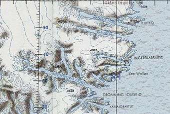
The Lindenow Fjord extends in an WNW/ESE direction for about 64 km. To the east the fjord opens into the North Atlantic Ocean south of Nanuuseq Fjord. Nanuuseq Island lies close to the northeast of the northern end of its mouth and larger Queen Louise Island at the southern end of its mouth.[3]
The fjord branches at its head with a number of glaciers feeding its waters. The Nørrearm, its largest tributary fjord, has its mouth on the northern shore of Lindenow Fjord, about 22 km from the Lindenow Fjord's mouth. Apostelens fjord drains into the Nørrearm from the west. In 1999 Apostlens fjord was filled by the Apostlenes Glacier in its innermost 2.5 km. In 2012 the ice tongue onto the fjord had disappeared.[4]
A little further west the Sønderarm, a smaller tributary fjord, branches southwards.
Igdlukulik, an archaeological site with the ruins of a former Inuit settlement lies by the shore where the Nørrearm branches north.[5]
Mountains
The massive Tiningnertok (Apostelen Tommelfinger), a 2,291.48 m (7,518.0 ft) ultra-prominent peak, rises steeply at 60°35′54″N 43°49′13″W / 60.59833°N 43.82028°W[6] from the shore east of small Tininnertooq Bay on the northern side of the middle section of the Lindenow Fjord, west of the mouth of the Nørrearm.[7] Akuliarusersuaq is another massive peak rising at 60°34′13″N 43°44′4″W / 60.57028°N 43.73444°W to a height of 1,534.67 m (5,035.0 ft) 3 km to the southeast.
See also
References
- ↑ "Lindenow Fjord". Geonames. Retrieved 20 April 2016.
- ↑ Prostar Sailing Directions 2005 Greenland and Iceland Enroute, p. 99
- ↑ "Lindenow Fjord". Mapcarta. Retrieved 20 April 2016.
- ↑ "Norrearm Fjord Glacier Retreat, Greenland". 9 December 2016.
- ↑ "Nørrearm". Mapcarta. Retrieved 20 April 2016.
- ↑ GoogleEarth
- ↑ The passing of noted French mountaineer Jean-Claude Marmier
External links
- Lindenow Fjord - Pictures
- The World Today - Lindenow Fjord, Greenland
- 2016 Greenland expedition with climbing of Apostelen Tommelfinger
- Mountaineering history in the area
- Den grønlandske Lods - Sejladsanvisninger Østgrønland
- Lindenows Fjord, Greenland, surrounding Apostelen Tommelfinger