Lincoln, Michigan
| Lincoln | |
|---|---|
| Village | |
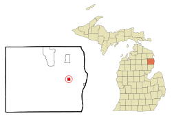 Location of Lincoln, Michigan | |
| Coordinates: 44°41′7″N 83°24′39″W / 44.68528°N 83.41083°WCoordinates: 44°41′7″N 83°24′39″W / 44.68528°N 83.41083°W | |
| Country | United States |
| State | Michigan |
| County | Alcona |
| Townships | Gustin, Hawes |
| Area[1] | |
| • Total | 1.06 sq mi (2.75 km2) |
| • Land | 0.83 sq mi (2.15 km2) |
| • Water | 0.23 sq mi (0.60 km2) 21.70% |
| Elevation | 814 ft (248 m) |
| Population (2010)[2] | |
| • Total | 337 |
| • Estimate (2016)[3] | 319 |
| • Density | 320/sq mi (120/km2) |
| Time zone | UTC-5 (EST) |
| • Summer (DST) | UTC-4 (EDT) |
| ZIP code | 48742 |
| Area code(s) | 989 |
| FIPS code | 26-47560[4] |
| GNIS feature ID | 0630440[5] |
Lincoln is a village in Alcona County in the U.S. state of Michigan. The population was 337 at the 2010 census. The village is situated on the boundary between Gustin Township on the south and Hawes Township on the north and is approximately evenly divided between them. The village is at the eastern corners of these townships and some development extends into the adjacent Harrisville Township and Haynes Township, although land from neither township is within the village's corporate boundaries.
Geography
- According to the United States Census Bureau, the village has a total area of 1.06 square miles (2.75 km2), of which 0.83 square miles (2.15 km2) is land and 0.23 square miles (0.60 km2) is water.[1]
- It is considered to be part of Northern Michigan.
Major highways


Demographics
| Historical population | |||
|---|---|---|---|
| Census | Pop. | %± | |
| 1910 | 122 | — | |
| 1920 | 178 | 45.9% | |
| 1930 | 250 | 40.4% | |
| 1940 | 295 | 18.0% | |
| 1950 | 409 | 38.6% | |
| 1960 | 441 | 7.8% | |
| 1970 | 371 | −15.9% | |
| 1980 | 361 | −2.7% | |
| 1990 | 337 | −6.6% | |
| 2000 | 364 | 8.0% | |
| 2010 | 337 | −7.4% | |
| Est. 2016 | 319 | [3] | −5.3% |
| Source: Census Bureau. Census 1960- 2000, 2010. | |||
2010 census
As of the census[2] of 2010, there were 337 people, 160 households, and 82 families residing in the village. The population density was 406.0 inhabitants per square mile (156.8/km2). There were 236 housing units at an average density of 284.3 per square mile (109.8/km2). The racial makeup of the village was 98.2% White and 1.8% from two or more races. Hispanic or Latino of any race were 2.7% of the population.
There were 160 households of which 23.1% had children under the age of 18 living with them, 37.5% were married couples living together, 8.1% had a female householder with no husband present, 5.6% had a male householder with no wife present, and 48.8% were non-families. 43.1% of all households were made up of individuals and 23.1% had someone living alone who was 65 years of age or older. The average household size was 2.11 and the average family size was 2.87.
The median age in the village was 43.2 years. 19.6% of residents were under the age of 18; 9.3% were between the ages of 18 and 24; 23.1% were from 25 to 44; 21.9% were from 45 to 64; and 25.8% were 65 years of age or older. The gender makeup of the village was 46.9% male and 53.1% female.
2000 census
As of the census[4] of 2000, there were 364 people, 179 households, and 102 families residing in the village. The population density was 474.8 per square mile (182.5/km²). There were 246 housing units at an average density of 320.9 per square mile (123.4/km²). The racial makeup of the village was 98.63% White, 0.27% African American, 0.27% Native American, and 0.82% from two or more races.
There were 179 households out of which 22.9% had children under the age of 18 living with them, 43.6% were married couples living together, 8.9% had a female householder with no husband present, and 42.5% were non-families. 39.7% of all households were made up of individuals and 25.1% had someone living alone who was 65 years of age or older. The average household size was 2.03 and the average family size was 2.63.
In the village, the population was spread out with 20.6% under the age of 18, 4.7% from 18 to 24, 24.5% from 25 to 44, 26.1% from 45 to 64, and 24.2% who were 65 years of age or older. The median age was 45 years. For every 100 females, there were 75.0 males. For every 100 females age 18 and over, there were 71.0 males.
The median income for a household in the village was $24,464, and the median income for a family was $29,821. Males had a median income of $30,179 versus $17,143 for females. The per capita income for the village was $16,860. About 13.1% of families and 15.7% of the population were below the poverty line, including 12.0% of those under age 18 and 20.9% of those age 65 or over.
Education
Alcona Community Schools operates public schools. The schools are Alcona Elementary School (K-6) and Alcona Community High School (7-12). The schools share the same campus, located on Barlow Road, south of Lincoln.[7]
Local events
- The annual Alcona County Fair is located at the Alcona Recreation Area site in Lincoln, Michigan and is held near the end of August.[8]
Lincoln Train Depot
The Lincoln Train Depot, originally called the "West Harrisville Depot", was built in 1886 by the Detroit, Bay City and Alpena Railroad, a predecessor to the Detroit and Mackinac Railway. It is the last remaining depot of its type in northeastern Michigan and is a standing reminder of Michigan's former dependence on the railroads. It is located on Lake Street at Fisk Street in downtown Lincoln and served the community and the surrounding area until 1929. Rail service passed through Lincoln from the south and north through Ossineke to Alpena. It is now owned by the Lincoln downtown Development Authority. In December 1998, the Lincoln Depot was officially recognized as a Michigan Historic Site.[9] Hours are from 1-4 pm Monday through Friday The Train Depot is the locale of Depot Days, a fund raising event sponsored by the Alcona Historical Society.[10] The display includes a restored caboose[11] and a switching engine from the D&M Railway.[12]
There are other D&M depots in Standish and Harrisville, Michigan.
Media
Newspapers
- The Alcona County Review, located in Harrisville, is the newspaper of record, and has served the community since 1877.[13]
- The Alpena News[14] is the daily newspaper of record for much of northeastern lower peninsula of Michigan.[15]
- Daily editions of the Detroit Free Press and The Detroit News are also available throughout the area.
Radio
Notes
- 1 2 "US Gazetteer files 2010". United States Census Bureau. Archived from the original on 2012-07-14. Retrieved 2012-11-25.
- 1 2 "American FactFinder". United States Census Bureau. Retrieved 2012-11-25.
- 1 2 "Population and Housing Unit Estimates". Retrieved June 9, 2017.
- 1 2 "American FactFinder". United States Census Bureau. Retrieved 2008-01-31.
- ↑ "US Board on Geographic Names". United States Geological Survey. 2007-10-25. Retrieved 2008-01-31.
- ↑ History of Michigan highways.
- ↑ "Alcona Elementary School Archived 2013-11-04 at the Wayback Machine.." Alcona Community Schools. Retrieved on November 3, 2013.
- ↑ Alcona County Government
- ↑ Listing of Depot as Historic site.
- ↑ Alcona Historical Society. Archived 2007-09-27 at the Wayback Machine.
- ↑ Michigan Caboose RR.
- ↑ U.S.23 Heritage Route.
- ↑ Alcona County Review
- ↑ The Alpena News
- ↑ Alpena News
External links
- Alcona Historical Society
- "Bibliography on Alcona County". Clarke Historical Library, Central Michigan University. Retrieved January 17, 2013.
- Huron Shores Chamber of Commerce (Alcona and portions of Iosco County)
Municipalities and communities of Alcona County, Michigan, United States | ||
|---|---|---|
| City | 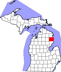 | |
| Village | ||
| Townships | ||
| Unincorporated communities | ||