Limpert Bay
| Limpert Bay Aberthaw Beach / Gileston Beach | |
|---|---|
 | |
| Coordinates: Coordinates: 51°23′13″N 3°24′54″W / 51.387°N 3.415°W | |
| Country | Wales |
| County borough | Vale of Glamorgan |
| Village | St Athan |
| Historic county | Glamorgan |
| Time zone | UTC+0 (GMT) |
| Post codes | CF62 |
| Area code(s) | 01446 |
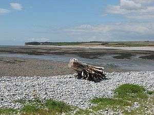
Limpert Bay is a beach on the Bristol Channel which connects to Watch House Beach to the East, the line of division is the run-off of the River Thaw and Summerhouse Bay to the West.
The beach is rock with some sand.[1] There is a guest house[2] and a free car park next to some cottage ruins.[3] An information stand at the beach gives the history of the area, provided by the Heritage Cost.[4]
The Wildlife Trust for Wales has helped record over one thousand species at this location, sixty-two of which are of principal concern to the conservation to the biodiversity of Wales.[5]
History
.jpg)
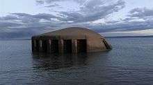
During World War II; Limpert Bay's defences formed part of the Western Command's coast "crust" defences for the Vale of Glamorgan. Defences included anti-tank cubes, pill boxes, and an anti-tank ditch.[6]
Industrial Area
The beach is next to Aberthaw Power Station. Two seawater intakes for the power station are in the bay.[7]
References
- ↑ http://www.nearestbeach.co.uk/bro-morgannwg-the-vale-of-glamorgan/limpert-bay-aberthaw-beach-cardiff/
- ↑ "Limpert Bay Guest House".
- ↑ "Limpert Bay on Blue Sea Surf".
- ↑ "Heritage Coast Document". Retrieved 30 June 2015.
- ↑ "Aberthaw".
- ↑ Administrator, walesonline (26 February 2008). "A century's legacy of Wales at war".
- ↑ "Limpert Bay on Good Beach Guide,".
