Colwinston
Colwinston
| |
|---|---|
 | |
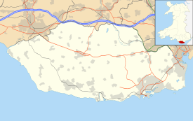 Colwinston Colwinston shown within the Vale of Glamorgan | |
| Population | 447 (2011) |
| Principal area | |
| Ceremonial county | |
| Country | Wales |
| Sovereign state | United Kingdom |
| Post town | Cowbridge |
| Postcode district | CF71 |
| Police | South Wales |
| Fire | South Wales |
| Ambulance | Welsh |
| EU Parliament | Wales |
| UK Parliament | |
| Welsh Assembly | |
Colwinston (Welsh: Tregolwyn) is both a village and a community in the Vale of Glamorgan, Wales approximately 4 miles (6.4 km) southeast of the centre of Bridgend and 21 miles (34 km) west of the centre of Cardiff. The village is located within 1⁄2 mile (0.80 km) of the A48. The population in 2005 was approximately 400.[1][2] The novelist Agatha Christie was a frequent visitor, and her descendants still live at the former manor house of Pwllywrach. A new development of 60 houses near the local school began in December 2015, after protests by local residents were overruled by the Vale of Glamorgan Council. Community representatives pointed to regular flooding and said that "adding 64 homes to a village with 130 at the moment can only increase that risk".[3]
History
The original Norman St Michael's Church in Colwinston is reputed to have been built in 1111.[4] The church was restored in 1879 and suffered a fire in 1971.[4]
The 1811 A Topographical Dictionary of The Dominion of Wales by Nicholas Carlisle said of the village:[5]
COLWINSTON, or, TRE COLLWYN, in the Cwmwd of Maenor Glynn Ogwr, Cantref of Cron Nedd (now called the Hundred of Ogmore),County of GLAMORGAN, South Wales: a discharged Vicarage, valued in the King's Books at £6..6..8; Patron, David Thomas, Esq.: Church dedicated to St. Michael. The Resident Population of this Parish, in 1801, was 235. The Money raised by the Parish Rates, in 1803, was £101..6..10, at 1s. 6d. per acre. It is 4 m. W. N. W. from Cowbridge. This Parish contains between fourteen and fifteen hundred acres of inclosed Land, and 60 acres of common Pasture, called The Golden Mile. According to the Diocesan Report, in 1809, the yearly value of this Benefice, arising from Vicarial Tythes, and Augmentation, was £111..18..0.
In 1835, the Seion Presbyterian Chapel was built but it closed in 1996; it later became a residential building.[4] In 1843, the Ebenezer Baptist Chapel was established and the building was completed in 1852. The last minister was the Rev A.E. Powell of Balarat, who served at the church between 1905 and 1944 before the church became part of a house.[4]
Archaeological and historical evidence
Bronze Age axe heads discovered on land at Highfield Farm[6] and Iron Age kilns are evidence of settlement during prehistoric times. It has been suggested that the impetus for an agrarian village lies in the gentle valley going east to west towards the village, providing a water supply and creating a natural bowl exists with a present-day exit leading down Church Lane.
Steep slopes in the central part of the village make it unlike other Vale villages in its topography. The water course is now underground but rises to the surface in prolonged wet weather. The older village houses are situated on the higher ground overlooking meadows, possibly built on the sites of older simple dwellings. Stock were fenced in at night and it is thought the area between Garden and Penlan Cottages and Church Cottage provided protection and water for this purpose. Title Deeds and old census records call this area ‘The Square’. A village well is present near Ty Draw Farm, and the remains of watercress beds show that it was harvested from the open water course there.
There is evidence of Roman activity in the Vale of Glamorgan, and their link to West Wales was along what would become the route of the A48. Llantwit Major Roman Villa is thought to have been built on a site occupied since the British Iron Age.[7] There was another excavation in 1971.[7][8] Following the end of Roman rule in Britain, the area was ruled by the medieval "princes" of Morgannwg; their kingdom included the area later known as Glamorgan. During this period the settlement came to be called "Colwinstūn", possibly from an old English name "Colwine" linked with "tūn", meaning farm or settlement.
According to local legend, Einion ap Gollwyn (Einion son of Collwyn) treacherously recruited the support of the new Norman invaders to Iestyn’s faction in a major battle at Hirwaun. The origins of this tradition are mentioned by G. J. Williams in Traddodiad Llenyddol Morgannwg (1948) .[9] This is now discredited [10] Robert Fitzhamon led the Norman invasion of the area from Bristol, probably by sea.[11]| Folklore has it that Fitzhamon's forces lined up for to receive their payment along a section of the A48 adjacent to Colwinston, resulting in the nickname of the "Golden Mile",[12] shown on old maps as being between Twmpath and the main village; another story suggests that troops in the Civil War gathered here for payment.[13]
Lands were divided up amongst the Norman incomers. William de Londres was granted the lordship of Ogmore (which included Colwinston) by Fitzhamon. William de Londres established Ewenny Priory in 1141 under the Benedictine Abbey in Gloucester and gave the churches of Ewenny, St Brides and Ogmore, Wick, Llampha and Colwinston with the ‘lands, meadows and all other things belonging unto them’ [14] to the Abbey. There is evidence that St Michael and All Angels Church, Colwinston, was founded in 1111, predating the Priory by 30 years.[15]
Middle Ages and after
Tithes were paid to the Rector as the representative of the landowner, Ewenny Priory and to the vicar to run the church. By 1539 English law had been extended to cover Wales and the County of Glamorgan was formally established as an administrative unit. Sir Edward Carne, a commissioner during the Dissolution of the Monasteries, was able to lease Ewenny Priory from the king, eventually purchasing it in 1545 for £727-6s-4d.[16] He also purchased priory land at Colwinston [17] Colwinston remained a pocket of recusancy, with priests continuing to administer the sacrament according to the Roman rite. Even into the 17th century,John Lloyd, a local priest under the protection of the Turbevilles at Penllin, was arrested and hanged, drawn and quartered on the Heath at Cardiff in 1679 at the height of the hysteria caused by the 'Popish Plot'.
On a 16th-century map of the area, the village appears to be recorded as Colwyns’ Tone. The village name was usually spelled as one word, most commonly as Colwinstone or Colwinston. The Ordnance Survey has used ‘Colwinston’ since 1833 (reflecting the usual pronunciation) but some official sources (e.g. census records, postmarks) included an -e until the 20th century.
The Welsh name of the village was not often recorded in official documents because of restrictions on the use of Welsh but it appears to be derived from the translation of tun as "Tref" ("town"), and the Welsh name "Colwyn" or "Collwyn", which also has a literal meaning of ‘cub, whelp, puppy’. "Colwyn" mutates to "golwyn" in Welsh because "tref" is a feminine noun. Tregolwyn first appears in writing c.1566 (tref golwyn) although it is likely to have originated at a much earlier date.
Of the ten Grade II listed buildings in the village, all date from the medieval or immediate post-medieval period. These include a thatched house, "The Old Parsonage", the former manor house of Pwllywrach, and several former farmhouses.[18]
16th to 19th century
The Norman tradition of primogeniture had taken over in Glamorgan, in contrast with traditional Welsh law. In the 1670s, With no sons to inherit, the Carne family lands were divided between two surviving Carne daughters upon their marriages. Colwinston thus became the property of Sir Edward Mansel, 4th Baronet, of Margam, when he married Martha Carne.[19] Some of the land on the northern side of village was owned by Jesus College, Oxford.
In 1747 Bussy Mansel, 4th Baron Mansel, succeeded to the title, and he sold the ‘Manor of Colwinston’ to David Thomas ‘of Bath’, who had married into the family that then owned the house at Pwllywrach, and built a new ‘Manor house’ there. Four generations later the Manor was again without a male heir after the death of Hubert be Burgh Thomas. His sister, Mary Anna Thomas, married Charles John Prichard (sometime after 1878) placing the land at Colwinston in trust for their son, Hubert Cecil Prichard.[20]
Small farms were either owned by the Pwllywrach estate and tenanted or had been sold by the estate in the past and were often then sold on to other farmers and landowners in this period. There was always an area of common land of approximately 70 acres, lying alongside the A48 known as the Golden Mile Common. This was ‘enclosed’ by an Act of Parliament called the ‘Golden Mile Award’ in 1871. The village population in the 19th century thus became formed around the Pwllywrach House and Hilton Farm, a number of small farm units stretching west-east from Ty Maen to the Yew Tree and Chapel Farms, north to Claypit and Highfield Farms and south to Stembridge and Parcau Farms, some labourers’ cottages (often owned by the Pwllywrach estate), the Church and the Parsonage (and the then Vicarage) and three chapels. Some farms on the higher ground had rain water storage tanks, other houses have been built along water courses to be able to access water using their own wells. Agriculture was supported by other trades including the Sycamore Tree Inn (recorded back to at least 1840, the building originates from the 17th century), a forge and blacksmith, baker, shoe maker, post office and horse breaker.
However, there was a substantial ‘churn’ in the village population from the middle part of the century. The farms did not provide for reasonable incomes for many and the new industrial developments around South Wales were beginning to attract people away from the village. Census records show that of the 268 people living in the village in 1861, only 98 had been living in the village in 1851. 168 people died or moved away in that decade, to be replaced by a high number of births and people moving in from West Wales and Ireland.[21] The 1861 census also shows some children to be attending a private school located on Twyn yr Eglwys. The origins of the present school are in the building now known as Ty Colwyn, where a school was established in 1871 under the 1870 Education Act as a ‘National’ school supported by the Church of England. There were 27 children on the original register. (This building is also thought also to be the original village tithe barn). From 1875 the school was funded through a voluntary Parish rate. The school moved to its present site in 1970. The Prichard family provided funds for a substantial church renovation in 1879, in 1881 open benches were put in accommodating more parishioners. Challenge to the Anglican church was expressed by the development of chapel communities in the village, particularly for the Welsh language speakers. The Seion (Methodist) Chapel was built in 1830, surviving until 1996. The Ebenezer Baptist Chapel was founded in 1843 and a building established in 1852 using part of Chapel Farm House. It continued in use until 1944. The baptismal pool was made in the river which was blocked off in the field below Cynma House.
In 1865, a village branch of the ‘Philanthropic Order of the True Ivorites Friendly Society’ was established, conducting its business in Welsh. This provided a vehicle for villagers with independent incomes to save, and then possibly to buy their own properties, it finally closed in 1960. The church was restored in 1879 by Henry J Williams of Bristol in the course of which the rood loft was discovered and the doors at the entrance and upper level replaced and a new door placed in the porch. New windows were inserted in the nave, the old stone pulpit replaced by an oak one and a new oak communion table, lectern and chancel furniture installed. The contractor was Thomas Thomas of Colwinston and the cost of £800 defrayed by Mrs Mary Collins Prichard who had recently come to live at Pwllywrach and, as patron of the ‘living’, wished to put the church in a good state of repair. In 1881 when additional accommodation was required for the then 64 parishioners the architect John Prichard simply reseated the church with open benches at a cost of £120.
Surplus agricultural produce was exported to Bristol (by sea) and then to the growing communities in the South Wales coalfields by rail. With motorised transport, the population could travel further afield (chapel outings for example), though obviously links further south and east remained limited by the Severn Estuary. There are slow changes to the population which also then begins to grow away from its agricultural origins. The industrial growth in the South Wales coalfields also provides an economic alternative for many as the need for intensive labour on farms is replaced by machinery and the village population declined. The industrial developments also generated new markets for agricultural produce. Some of the original houses fall into disrepair as these population movements took place.
Twenty three villagers signed up to the First World War and all returned, so the village is one of only three Thankful Villages in Wales. Colonel Hubert Cecil Prichard came to live at Pwllywrach after the First World War. His son Hubert de Burgh Prichard famously married Rosalind Christie, the only daughter of Agatha Christie, their son Mathew Prichard being given the proceeds from the royalties of The Mousetrap. He subsequently used the substantial sums from the play to establish the Colwinston Charitable Trust in 1995.[22]
Gradually ‘modern’ features eventually found their way to the village including mains water in 1935, and electricity and telephone (in the form of the kiosk) from 1946 onwards. A new water main was laid from the A48 in 1972 and a new sewerage scheme laid in 1973. Beech Park was built in the 1960s with other small developments following. The farm buildings between the Ty Maen Farm and Colwinston House (built originally as a Dower House for Pwllywrach) were gradually sold as residential houses, with the barns and rickyards between the farm houses also being sold off for development.
The agricultural land in and around the village is now variously owned by the Pwllyrwrach Estate, a number of independent landowners (especially to the north and west of the village) as well as a small number of independent farmers who have bought and/or inherited land over the centuries. Other properties are owned by the Vale of Glamorgan Council for the school, the Village Hall and the remaining social housing. Finally, most private housing is now owned by individual house owners, either as recently built housing or older houses purchased originally from the Pwllywrach estate, the Council, the Chapel organisations and the Church or other original villagers and farmers.
The main fabric of the village was thus set until 2016 when the developer Redrow plc built 65 new homes on land now known as Heol Cae Pwll, increasing the village housing stock and population by 50%. This has brought many new families to the village to join with and support a particularly vibrant set of community organisations for which the village has become known. With this has also come ‘fibre’ broadband to extend the opportunities and challenges provided by the internet.
Demographics
Colwinston's population was 447, according to the 2011 census;[1] a 10.1% increase since the 406 people noted in 2001.[23] The 2011 census showed 13.1% of the population could speak Welsh, a rise from 7.8% in 2001.[24]
Church of St Michael & All Angels
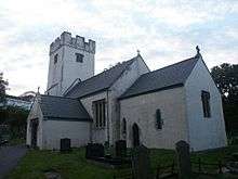
The original Norman church in Colwinston is reputed to have been built in 1111. The medieval parish church is a Grade 1 listed building. Restoration work was carried out on the church in 1971 following a fire which badly damaged the chancel, destroying the brass tablets either side of the altar displaying the Ten Commandments. It was at this time that the words “Holy, Holy, Holy” painted in scroll work above the chancel arch were painted over.
Further restoration work at the church was carried out at the millennium[25] with the benefit of a major grant from the Heritage Lottery Fund together with grants from other bodies and funds raised by the villagers. A vestry, kitchen and toilet were built on the north side of the church, the interior and exterior walls were lime washed and the roof repaired at a cost of £350,000.
Other landmarks
The Sycamore Tree pub is run by Brains Brewery and dates to 1650 or earlier.
In May 1865, The Philanthropic Order of True Ivorites Friendly Society was established and registered there.[4] A thatched house dating to the 16th century at the crossroads and opposite the southeast corner of churchyard has a Gothic or Tudor arch and the building is "one of only two in Glamorgan with a latrine in the form of a small closet at the side of the fireplace."[4] Nearby are St David's Church in Wales Primary School, the village hall and the village green.
Colwinston is one of only three villages in Wales which suffered no fatalities in World War I and one of only 53 Thankful Villages in the UK. However, the village lost four men in World War II, one of whom was Agatha Christie's son-in-law, Colonel Hubert Prichard.[26] Welcome signs at the entrance to the village reflected its status as a thankful village from but the village had no war memorial until 2014, when one was erected on the village green.[27]
Culture
Colwinston has its own community council with seven elected members.[28] The major social event of the year is the annual village festival, usually held during the first or second week in July. Other annual events include a pantomime and the New Year's Day sport of "collyball". A multi-use games area (MUGA) was constructed close to the village hall in 2013.[29]
References
- 1 2 "Area: Colwinston(Parish)". Office for National Statistics. 30 January 2013. Retrieved 14 August 2015.
- ↑ "Descriptive Gazetteer Entry for VIA JULIA". A Vision of Britain Through Time. Retrieved 3 May 2017.
- ↑ "Colwinston residents set to oppose Redrow housing plan". The Barry Gem. 15 January 2015. Retrieved 19 August 2016.
- 1 2 3 4 5 6 "County Treasures" (PDF). Vale of Glamorgan Council. Archived from the original (PDF) on 3 March 2016. Retrieved 19 April 2012.
- ↑ Carlisle, Nicholas (1811). "A Topographical Dictionary of The Dominion of Wales". accessed via Colwinston community website.
- ↑ "Bronze age axes from the Vale of Glamorgan declared treasure". BBC News Wales. 3 May 2013. Retrieved 15 February 2018.
- 1 2 CAERMEAD ROMAN SITE;LLANTWIT MAJOR ROMAN VILLA, Coflein
- ↑ Llantwit Major Roman villa on Roman Britain Archived 2008-10-10 at the Wayback Machine.
- ↑ Robert Thomas Jenkins. "EINION ap COLLWYN (fl. 1100?)". Dictionary of Welsh Biography. National Library of Wales. Retrieved 15 February 2018.
- ↑ Griffiths, R.A. The Norman Conquest and the Twelve Knights of Glamorgan in Williams, S. Glamorgan Historian, Vol 3. Pub: D Brown and Sons. Cowbridge 1966
- ↑ Charles Arnold-Baker (2001). The Companion to British History. Psychology Press. pp. 904–. ISBN 978-0-415-18583-7.
- ↑ "ROBERT FITZHAMON, THE TWELVE KNIGHTS & 'THE GOLDEN MILE'". Hello Historia. 23 March 2012. Retrieved 15 February 2018.
- ↑ "Colwinston". Hellfire Corner. Retrieved 25 March 2018.
- ↑ quoted in Gloucester Chronicles
- ↑ "Colwinston-Vale of Glamorgan County Treasures" (PDF). Vale of Glamorgan Council. 2007. p. 16. Archived from the original (PDF) on March 3, 2016.
- ↑ "Ewenny Priory (house)". British Listed Buildings. Retrieved 4 September 2017.
- ↑ Williams, G. The Ecclesiastical History of Glamorgan 1527-1642 in Williams, G. (ed) Glamorgan County History Vol IV, pub: University of Wales Press 197
- ↑ "Listed Buildings in Colwinston, Vale of Glamorgan". British Listed Buildings. Retrieved 28 September 2018.
- ↑ "MANSEL family, of Oxwich, Penrice, and Margam abbey, Glam". Dictionary of Welsh Biography. National Library of Wales. Retrieved 29 September 2018.
- ↑ Chris Hawker (2018). Colwinston: a historical journey. Cowbridge History Society. ISBN 9781999687403.
- ↑ James, B.Ll. The Vale of Glamorgan, 1840-1860: Profile of a Rural Community in Williams, S. Glamorgan Historian, Vol 5. Pub: D Brown and Sons. Cowbridge 1968
- ↑ "Colwinston Charitable Trust". Colwinston Charitable Trust. Retrieved 28 May 2018.
- ↑ "Area: Colwinston (Parish)". Office for National Statistics. 18 November 2004. Retrieved 14 August 2015.
- ↑ "2011 Census results by Community". Welsh Language Commissioner. 2015. Retrieved 14 August 2015.
- ↑ "Conservation Area, Colwinston - Appraisal and Management Plan" (PDF). Directorate of Environmental and Economic Regeneration. March 2009. Retrieved 20 February 2018.
- ↑ BBC: The Thankful Villages of Wales. Accessed 4 August 2013
- ↑ Peter Collins (23 October 2014). "'Thankful Village' Colwinston preparing its own war memorial to mark the 100th anniversary of World War One". WalesOnline. Retrieved 19 August 2016.
- ↑ Colwinston Community Council official website
- ↑ Creative Rural Communities - "Colwinston Community Consultation" 2012. Accessed 11 March 2014
Further reading
- Colwinston Conservation Area Appraisal and Management Plan. Pub: Vale of Glamorgan Council, Barry. 2009
- Griffiths, R.A. The Norman Conquest and the Twelve Knights of Glamorgan in Williams, S. Glamorgan Historian, Vol 3. Pub: D Brown and Sons. Cowbridge
- Howell, D. Farming in Southeast Wales c180 in Baber, C.and Williams, L.J.(eds) Modern South Wales: Essays in Economic History University of Wales Press. Cardiff. 1986
- James, B. The Origins of the Ramoth Chapel, Cowbridge in James, B. (Ed) Cowbridge and Llanbethian An Historical Medley. Pub: Cowbridge Historical Society. 2016
- James, B.Ll. ‘Vale of Glamorgan’ in Williams S (Ed) ‘South Glamorgan: A County History’ Pub: Stewart Williams, Barry. 1974
- James, B.Ll. The Vale of Glamorgan, 1840-1860: Profile of a Rural Community in Williams, S. Glamorgan Historian, Vol 5. Pub: D Brown and Sons. Cowbridge
- Richard, A.J. The Religious Houses of Glamorgan in Williams, S. Glamorgan Historian, Vol 2. Pub: D Brown and Sons. Cowbridge
- Thomas, R.G. ‘A History of Colwinston’; Pub: R.G. Thomas. 2001
External links

| Wikimedia Commons has media related to Colwinston. |