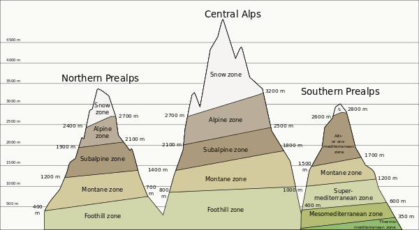
Life zones of central Europe
.png)
Central Europe contains several life zones, depending on location and elevation.
Geographically, Central Europe lies between the Baltic Sea and the Apennine and Balkan peninsulas. It includes the plains of Germany and Poland; the Alps; and the Carpathian Mountains. The Central European Flora region stretches from Central France to Central Romania and Southern Scandinavia.[1] The lowlands of Central Europe contain the Central European mixed forests ecoregion,[2] while the mountains host the Alps conifer and mixed forests[3] and Carpathian montane conifer forests ecoregions.[4]
An important factor in the local climate and ecology of Central Europe is the elevation: an increase of elevation by 1,000 metres (3,300 ft) causes the average air temperature to drop by 5 °C (41 °F) and decreases the amount of water that can be held by the atmosphere by 30%. This decrease in temperature and increase in rainfall result in altitudinal zonation, where the land can be divided into life zones of similar climate and ecology, depending on elevation.
Life zones

The life zones of the Eastern and Central Alps are:[5][6][7][8][9][10]
- Planar zone, under 300 m (East Alps), under 150 m (Central German hills), agriculture.
- Foothill zone, 300 – 800 m (East Alps), 150 – 300 m (Central German hills), oak limit (Quercus spp.). European Beech (Fagus sylvatica), Sessile oak (Quercus petraea), Pedunculate oak or English oak (Quercus robur), European or common hornbeam (Carpinus betulus) and small-leaved Lime (Tilia cordata). Grape crop limit (Vitis spp.), around 600 m, Switzerland, North Side, South Slope, estimated 7.5 °C. Crops: maize for feed; sweet maize (Zea mays).
- Submontane zone, 700 - 1,000 m (East Alps), 300 – 450 m (Central German hills), European Beech (Fagus sylvatica), Silver Fir or European Silver Fir (Abies alba) and Norway Spruce (Picea abies). Coniferous forests by reforestation limit around 800 m, North Side.
- Montane zone, 800 – 1,200 m (East Alps), 450 – 650 m (Central German hills), rye (Secale cereale) and wheat (Triticum spp.) crop limit.
- Mid-montane zone, 1,000 – 1,400 m (East Alps), 650 – 800 m (Central German hills). Limit of the whole year populated areas. Limit of a growing season of more than 100 days.
- Altimontane zone, 1,300 – 1,850 m (East Alps), 800 – 1,500 m (Central German hills). Deciduous forests limit, Sycamore Maple (Acer pseudoplatanus) and European Beech (Fagus sylvatica).
- Subalpine zone, 1,500 – 2,500 m (East Alps), above 1,500 m (Central German hills), Scots Pine (Pinus sylvestris), Norway Spruce (Picea abies), Swiss Pine (Pinus cembra, Arve or Zirbel) limit and European Larch (Larix decidua) limit, 2,000 m, some specimens up to 2,850 m, South Slope. Tree line and Krummholz zone or ecotone (stunted subalpine bushes), Sub-alpine meadow and Alpine climate.
- Alpine zone, 2,000 - 3,000 m (East Alps), Montane grasslands and shrublands. Mountain Pine or Mugo Pine (Pinus mugo) limit. Alpine meadows just used in the warm season.
- Snow zone, above 3,000 m (East Alps), alpine desert, scree, permafrost and above snow line.
Climate
Location, avg annual precipitation (mm), altitude (amsl) and avg annual temperature (°C):[11]
| Approx. coordinates of the weather station | Precipitation | Altitude | Temperature | |
|---|---|---|---|---|
| Weissfluhjoch | 46°50′0″N 9°48′23″E / 46.83333°N 9.80639°E | 1,158 mm | 2,690 m | -3.2 °C |
| Pilatus | 46°58′45″N 8°15′22″E / 46.97917°N 8.25611°E | 1,842 mm | 2,106 m | 0.9 °C |
| Napf | 47°0′15″N 7°56′24″E / 47.00417°N 7.94000°E | 1,355 mm | 1,406 m | 4.0 °C |
| Engelberg | 46°50′0″N 8°23′0″E / 46.83333°N 8.38333°E | 1,571 mm | 1,035 m | 5.4 °C |
| Buchs-Suhr | 47°23′0″N 08°04′0″E / 47.38333°N 8.06667°E | 1,027 mm | 387 m | 8.6 °C |
See also
References
- ↑ Frey, Wolfgang; Lösch, Rainer (2004). "Pflanze und Vegetation in Raum und Zeit". Lehrbuch der Geobotanik. München: Spektrum Akademischer Verlag.
- ↑ "Central European mixed forests". Terrestrial Ecoregions. World Wildlife Fund.
- ↑ "Alps conifer and mixed forests". Terrestrial Ecoregions. World Wildlife Fund.
- ↑ "Carpathian montane conifer forests". Terrestrial Ecoregions. World Wildlife Fund.
- ↑ Ellenberg, Heinz (1996). Vegetation Mitteleuropas mit den Alpen in ökologischer, dynamischer und historischer Sicht. Stuttgart: Ulmer. ISBN 3-8252-8104-3.
- ↑ Mayer, Hannes (1974). Wälder des Ostalpenraumes. Standort, Aufbau und waldbaulichen Bedeutung der wichtigsten Waldgesellschaften in den Ostalpen samt Vorland. Ökologie der Wälder und Landschaften vol. 3. Stuttgart, New York: Gustav Fischer Verlag. p. 344. ISBN 3-437-30166-7.
- ↑ Mayer, Hannes (1984). Wälder Europas. Stuttgart, New York: Gustav Fischer Verlag. p. 691. ISBN 3-437-30441-0. Retrieved 2010-05-06.
- ↑ Wittmann, O. (1983). Standortkundliche Landschaftsgliederung von Bayern. Materialien. 21. München: Bayerisches Staatsministerium für Landesentwicklung und Umweltfragen.
- ↑ Kilian, W.; F. Müller; F. Starlinger (1993). Die forstlichen Wuchsgebiete Österreichs. Eine Naturraumgliederung nach waldökologischen Gesichtspunkten. Wien: Forstliche Bundesversuchsanstalt. p. 53. ISSN 0374-9037. (Webdokument, pdf; online: "Die forstlichen Wuchsgebiete Österreichs". Institut für Waldökologie und Boden, BfW. 2005-03-15. Archived from the original on 2008-04-11. Retrieved 2008-03-12. )
- ↑ Härdtle, W.; Ewald, J.; Hölzel, N. (2004). Wälder des Tieflandes und der Mittelgebirge. Ökosysteme Mitteleuropas in geobotanischer Sicht. Stuttgart: Ulmer. p. 257.
- ↑ "Klimadiagramme".