Lewa Airport
| Lewa Airport | |||||||||||
|---|---|---|---|---|---|---|---|---|---|---|---|
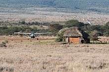 Lewa Airport with departure lounge and plane on stand | |||||||||||
| Summary | |||||||||||
| Airport type | Public, Civilian | ||||||||||
| Owner | Kenya Airports Authority | ||||||||||
| Serves | Lewa Wildlife Conservancy | ||||||||||
| Location |
Lewa Downs, | ||||||||||
| Elevation AMSL | 5,500 ft / 1,700 m | ||||||||||
| Coordinates | 00°11′34″N 37°28′21″E / 0.19278°N 37.47250°E | ||||||||||
| Map | |||||||||||
 Lewa Location of Lewa Airport in Kenya Placement on map is approximate | |||||||||||
| Runways | |||||||||||
| |||||||||||
Location
Lewa Airport (IATA: n/a, ICAO: n/a) is located in Lewa Wildlife Conservancy, in Isiolo District, Eastern Province (Kenya).
Its location is approximately 198 kilometres (123 mi), by air, north of Nairobi International Airport, the country’s largest civilian airport.[1] The geographic coordinates of Lewa Airport are: 0° 11' 34.00"N, 37° 28' 21.00"E (Latitude:0.192778; Longitude:37.472500).
Overview
Lewa Airport is a small civilian airport, serving Lewa Wildlife Conservancy and surrounding communities. Situated at 5,500 feet (1,700 m) above sea level,[2] the airport has an unpaved runway that measures 4,100 feet (1,200 m) in length.[3]
Airlines and destinations
| Airlines | Destinations |
|---|---|
| Airkenya Express | Nairobi–Wilson |
| Safarilink | Maasai Mara, Nairobi–Wilson |
See also
References
- ↑ "Distance between Lewa (Eastern) and Jomo Kenyatta Airport Nairobi (Nairobi Area) (Kenya)". distancecalculator.globefeed.com. Retrieved 2018-08-21.
- ↑ "KE-6885 pilot info @ OurAirports". www.ourairports.com. Retrieved 2018-08-21.
- ↑ "Airports in Kenya". www.aircraft-charter-world.com. Retrieved 2018-08-21.
External links
Coordinates: 0°11′34″N 37°28′21″E / 0.192778°N 37.472500°E
This article is issued from
Wikipedia.
The text is licensed under Creative Commons - Attribution - Sharealike.
Additional terms may apply for the media files.