Lenine Raion
| Lenine Raion Ленинский район | |||
|---|---|---|---|
| Raion | |||
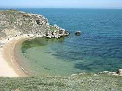 Kazantip, Leninsky District | |||
| |||
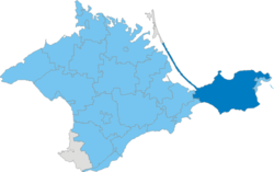 Location within Crimea | |||
| Country | Disputed: | ||
| Republic | Crimea | ||
| Capital | Lenine | ||
| Subdivisions |
List
| ||
| Area | |||
| • Total | 2,919 km2 (1,127 sq mi) | ||
| Population (2014) | |||
| • Total | 61,143 | ||
| • Density | 21/km2 (54/sq mi) | ||
| Time zone | UTC+3 (MSK) | ||
| Dialing code | +380-6557 | ||
| Website |
lenino | ||
.svg.png)
_gerb.png)
Lenine Raion (Russian: Ленинский район, Ukrainian: Ленінський район, Crimean Tatar: Yedi Quyu rayonı) is one of the 25 regions of the Crimea, currently subject to a territorial dispute between the Russian Federation and Ukraine. It is located in the eastern part of the peninsula. The administrative centre of Lenine Raion is the urban-type settlement of Lenine. Population: 61,143 (2014 Census).[1]
References
- ↑ Russian Federal State Statistics Service (2014). "Таблица 1.3. Численность населения Крымского федерального округа, городских округов, муниципальных районов, городских и сельских поселений" [Table 1.3. Population of Crimean Federal District, Its Urban Okrugs, Municipal Districts, Urban and Rural Settlements]. Федеральное статистическое наблюдение «Перепись населения в Крымском федеральном округе». ("Population Census in Crimean Federal District" Federal Statistical Examination) (in Russian). Federal State Statistics Service. Retrieved January 4, 2016.
| Raions | |||||
|---|---|---|---|---|---|
| Municipalities | |||||
| Cities |
| ||||
| |||||
Coordinates: 45°17′51″N 35°46′26″E / 45.29750°N 35.77389°E
This article is issued from
Wikipedia.
The text is licensed under Creative Commons - Attribution - Sharealike.
Additional terms may apply for the media files.