Krasnohvardiiske Raion
| Krasnohvardiiske Raion Красногвардейский район | |||
|---|---|---|---|
| Raion | |||
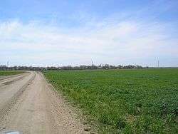 Village Grigoryevka, Krasnohvardeysky District | |||
| |||
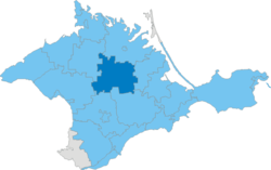 Raion location within Crimea | |||
| Country | Disputed: | ||
| Republic | Crimea | ||
| Capital | Krasnohvardiiske | ||
| Subdivisions |
List
| ||
| Area | |||
| • Total | 1,766 km2 (682 sq mi) | ||
| Population (2014) | |||
| • Total | 83,135 | ||
| • Density | 47/km2 (120/sq mi) | ||
| Time zone | UTC+3 (MSK) | ||
| Dialing code | +380-6556 | ||
| Website |
krgv | ||
Krasnohvardiiske Raion (Ukrainian: Красногвардійський район, Russian: Красногвардейский район, Crimean Tatar: Qurman rayonı) is one of the 25 regions of the Autonomous Republic of Crimea, a territory recognized by a majority of countries as part of Ukraine and annexed by Russia. The administrative center of the raion is the urban-type settlement of Krasnohvardiiske. Krasnohvardiiske Raion is located in the central part of Crimea. Population: 83,135 (2014 Census).[1]
References
- ↑ Russian Federal State Statistics Service (2014). "Таблица 1.3. Численность населения Крымского федерального округа, городских округов, муниципальных районов, городских и сельских поселений" [Table 1.3. Population of Crimean Federal District, Its Urban Okrugs, Municipal Districts, Urban and Rural Settlements]. Федеральное статистическое наблюдение «Перепись населения в Крымском федеральном округе». ("Population Census in Crimean Federal District" Federal Statistical Examination) (in Russian). Federal State Statistics Service. Retrieved January 4, 2016.
| Raions | |||||
|---|---|---|---|---|---|
| Municipalities | |||||
| Cities |
| ||||
| |||||
Coordinates: 45°29′41″N 34°17′41″E / 45.49472°N 34.29472°E
This article is issued from
Wikipedia.
The text is licensed under Creative Commons - Attribution - Sharealike.
Additional terms may apply for the media files.