Lena River
| Lena River (Лена, Зүлгэ, Елюенэ, Өлүөнэ) | |
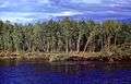
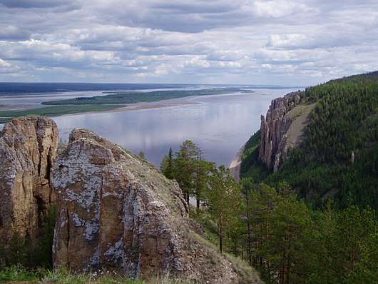 The Lena Pillars along the river near Yakutsk | |
| Country | Russia |
|---|---|
| Tributaries | |
| - left | Kirenga, Vilyuy |
| - right | Vitim, Olyokma, Aldan |
| Source | |
| - location | Baikal Mountains, Irkutsk Oblast, Russia |
| - elevation | 1,640 m (5,381 ft) |
| Mouth | Lena Delta |
| - location | Arctic Ocean, Laptev Sea |
| Basin | 2,500,000 km2 (965,255 sq mi) |
| Discharge | for Laptev Sea[1] |
| - average | 16,871 m3/s (595,794 cu ft/s) |
| - max | 241,000 m3/s (8,510,835 cu ft/s) |
| - min | 366 m3/s (12,925 cu ft/s) |
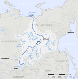 Lena River watershed | |
The Lena (Russian: Ле́на, IPA: [ˈlʲɛnə]; Russian Buryat: Зүлхэ; Evenki: Елюенэ; Sakha: Өлүөнэ) is the easternmost of the three great Siberian rivers that flow into the Arctic Ocean (the other two being the Ob' and the Yenisey). With a mean annual discharge of 588 cubic kilometers per year, it is the second largest of the Arctic rivers (after the Yenisey)[2]. It is the largest river whose catchment is entirely within the Russian territorial boundaries. Permafrost underlies most of the catchment, with 77% of the catchment containing continuous permafrost.
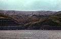
Course
Originating at an elevation of 1,640 meters (5,381 ft) at its source in the Baikal Mountains south of the Central Siberian Plateau, 7 kilometres (4 mi) west of Lake Baikal, the Lena flows northeast, being joined by the Kirenga River, Vitim River and Olyokma River. From Yakutsk it enters the lowlands and flows north until joined by its right-hand tributary the Aldan River and its most important left-hand tributary, the Vilyuy River. After that, it bends westward, flowing alongside the Verkhoyansk Range and then making its way nearly due north to the Laptev Sea, a division of the Arctic Ocean, emptying south-west of the New Siberian Islands by the Lena Delta – 30,000 square kilometres (11,583 sq mi) in area,[3] and traversed by seven principal branches, the most important being the Bykovsky channel, farthest east.
Basin
The area of the Lena river basin is calculated at 2,490,000 square kilometres (961,394 sq mi) and the mean annual discharge is 588 cubic kilometers per year. Gold is washed out of the sands of the Vitim and the Olyokma, and mammoth tusks have been dug out of the delta.
Tributaries
The Kirenga River flows north between the upper Lena River and Lake Baikal. The Vitim River drains the area northeast of Lake Baikal. The Olyokma River flows north. The Amga River makes a long curve southeast and parallel to the Lena and flows into the Aldan. The Aldan River makes similar curve southeast of the Aldan and flows into the Lena north of Yakutsk. The Maya River, a tributary of the Aldan, drains an area almost to the Sea of Okhotsk. The T-shaped Chona-Vilyuy River system drains most of the area to the west.
History
| Lena River from a source to Kachug | ||||||||||||||||||||||||||||||||||||||||||||||||||||||||||||||||||||||||||||||||||||||||||||||||||||||||||||||||||||||||||||||||||||||||||||||||||||||||||||||||||||||||||||||||||||||||||||||||||||||||
|---|---|---|---|---|---|---|---|---|---|---|---|---|---|---|---|---|---|---|---|---|---|---|---|---|---|---|---|---|---|---|---|---|---|---|---|---|---|---|---|---|---|---|---|---|---|---|---|---|---|---|---|---|---|---|---|---|---|---|---|---|---|---|---|---|---|---|---|---|---|---|---|---|---|---|---|---|---|---|---|---|---|---|---|---|---|---|---|---|---|---|---|---|---|---|---|---|---|---|---|---|---|---|---|---|---|---|---|---|---|---|---|---|---|---|---|---|---|---|---|---|---|---|---|---|---|---|---|---|---|---|---|---|---|---|---|---|---|---|---|---|---|---|---|---|---|---|---|---|---|---|---|---|---|---|---|---|---|---|---|---|---|---|---|---|---|---|---|---|---|---|---|---|---|---|---|---|---|---|---|---|---|---|---|---|---|---|---|---|---|---|---|---|---|---|---|---|---|---|---|---|
| ||||||||||||||||||||||||||||||||||||||||||||||||||||||||||||||||||||||||||||||||||||||||||||||||||||||||||||||||||||||||||||||||||||||||||||||||||||||||||||||||||||||||||||||||||||||||||||||||||||||||
It is commonly believed that the Lena derives its name from the original Even-Evenk name Elyu-Ene, which means "the Large River".
According to folktales related a century later, in the years 1620–1623 a party of Russian fur hunters under the leadership of Demid Pyanda sailed up Lower Tunguska, discovered the Lena, and either carried their boats there or built new ones. In 1623 Pyanda explored some 2,400 kilometres (1,500 mi) of the river from its upper reaches to the central Yakutia.[4] In 1628 Vasily Bugor and 10 men reached the Lena, collected 'yasak' (tribute) from the natives and then founded Kirinsk in 1632. In 1631 the voyevoda of Yeniseisk sent Pyotr Beketov and 20 men to construct an ostrog at Yakutsk (founded in 1632). From Yakutsk other expeditions spread out to the south and east. The Lena delta was reached in 1633.
Baron Eduard Von Toll, accompanied by Alexander von Bunge, led an expedition that explored the Lena delta and the islands of New Siberia on behalf of the Russian Imperial Academy of Sciences in 1885. In 1886 they investigated the New Siberian Islands and the Yana River and its tributaries. During one year and two days the expedition covered 25,000 kilometres (16,000 mi), of which 4,200 kilometres (2,600 mi) were up rivers, carrying out geodesicsurveys en route.
The Lena massacre was the name given to the 1912 shooting-down of striking goldminers and local citizens who protested at the working conditions in the mine near Bodaybo in northern Irkutsk. The incident was reported in the Duma (parliament) by Kerensky and is credited with stimulating revolutionary feeling in Russia.
Vladimir Ilyich Ulyanov may have taken his alias, Lenin, from the river Lena, when he was exiled to the Central Siberian Plateau.
Delta
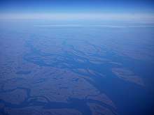
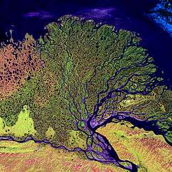
At the end of the Lena River there is a large delta that extends 100 kilometres (62 mi) into the Laptev Sea and is about 400 km (250 mi) wide. The delta is frozen tundra for about seven months of the year, but in May the region is transformed into a lush wetland for the next few months. Part of the area is protected as the Lena Delta Wildlife Reserve.
The Lena delta divides into a multitude of flat islands. The most important are (from west to east): Chychas Aryta, Petrushka, Sagastyr, Samakh Ary Diyete, Turkan Bel'keydere, Sasyllakh Ary, Kolkhoztakh Bel'keydere, Grigoriy Diyelyakh Bel'kee (Grigoriy Islands), Nerpa Uolun Aryta, Misha Bel'keydere, Atakhtay Bel'kedere, Arangastakh, Urdiuk Pastakh Bel'key, Agys Past' Aryta, Dallalakh Island, Otto Ary, Ullakhan Ary and Orto Ues Aryta.
Turukannakh-Kumaga is a long and narrow island off the Lena delta's western shore.
One of the Lena delta islands, Ostrov Amerika-Kuba-Aryta or Ostrov Kuba-Aryta, was named after the island of Cuba during Soviet times. It is on the northern edge of the delta.[5]
Gallery

.jpg) Map of mammoth place near Sagastyr (from the 1886 Bulletin de l'Académie Impériale des Sciences de St.-Pétersbourg)
Map of mammoth place near Sagastyr (from the 1886 Bulletin de l'Académie Impériale des Sciences de St.-Pétersbourg)
Further reading
- Alexander von Bunge & Baron Eduard Von Toll (1887), The Expedition to the New Siberian Islands and the Yana country, equipped by the Imperial Academy of Sciences.
See also
- Lena Pillars
- List of rivers of Russia
- List of longest undammed rivers
- William Barr, writer of The First Soviet Convoy to the Mouth of the Lena.
References
- ↑ http://www.abratsev.narod.ru/biblio/sokolov/p1ch23b.html, Sokolov, Eastern Siberia // Hydrography of USSR. (in russian)
- ↑ "Arctic Great Rivers Observatory". Arctic Great Rivers. Retrieved 2018-04-10.
- ↑ "Lena River Delta - A Global Ecoregion". World Wide Fund for Nature. 2006-07-06. Archived from the original on 2007-06-30. Retrieved 2008-05-23.
- ↑ "�������� �������� ������� � ��������� ������". www.randewy.ru. Retrieved 4 April 2018. replacement character in
|title=at position 1 (help) - ↑ "Google Maps". Google Maps. Retrieved 4 April 2018.

External links
- Arctic Great Rivers Observatory (ArcticGRO)
- NASA Earth Observatory page on flooding on the Lena River
- Information and a map of the Lena's watershed
- Permafrost in the Lena Delta
- Alfred Wegner institute (AWI) Publications, Berichte zur Polar- und Meeresforschung (Reports on polar and marine research) - free, downloadable research reports on the biology, geology, oceanography, hydrology, paleontology, paleoclimatology, fauna, flora, soils, cryology, and so forth of the Lena Delta, Laptev Sea, and other parts of the Arctic Circle.
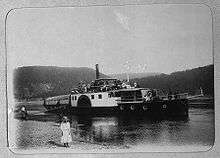
Shipbuilding and shipping on the Lena River | |||||||
|---|---|---|---|---|---|---|---|
| Shipbuilding |
| ||||||
| River ports |
| ||||||
| Ship types | |||||||
| Well-known vessels |
| ||||||
| Well-known travels |
| ||||||
| River accidents | |||||||
| Significant persons |
| ||||||
Coordinates: 73°N 127°E / 73°N 127°E
| Authority control |
|---|