Leinfelden-Echterdingen
| Leinfelden-Echterdingen | ||
|---|---|---|
| ||
 Leinfelden-Echterdingen Location of Leinfelden-Echterdingen within Esslingen district 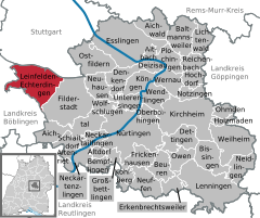  | ||
| Coordinates: 48°41′34″N 9°8′34″E / 48.69278°N 9.14278°ECoordinates: 48°41′34″N 9°8′34″E / 48.69278°N 9.14278°E | ||
| Country | Germany | |
| State | Baden-Württemberg | |
| Admin. region | Stuttgart | |
| District | Esslingen | |
| Area | ||
| • Total | 29.90 km2 (11.54 sq mi) | |
| Elevation | 432 m (1,417 ft) | |
| Population (2017-12-31)[1] | ||
| • Total | 39,826 | |
| • Density | 1,300/km2 (3,400/sq mi) | |
| Time zone | CET/CEST (UTC+1/+2) | |
| Postal codes | 70771 | |
| Dialling codes | 0711 | |
| Vehicle registration | ES | |
| Website | www.leinfelden-echterdingen.de | |

Leinfelden-Echterdingen is a town in the district of Esslingen, in Baden-Württemberg, Germany. It is located approximately 10 km south of Stuttgart, near the Stuttgart Airport and directly adjacent to the newly built Stuttgart Trade Fair. It was formed on January 1, 1975 by the merging of four towns - Leinfelden, Echterdingen, Stetten and Musberg. Zeppelin LZ 4 caught fire and burned out in Echterdingen in August 1908.
International relations
Leinfelden-Echterdingen is twinned with:


References
- ↑ "Bevölkerung nach Nationalität und Geschlecht am 31. Dezember 2017". Statistisches Landesamt Baden-Württemberg (in German). 2018.
External links

| Authority control |
|---|
This article is issued from
Wikipedia.
The text is licensed under Creative Commons - Attribution - Sharealike.
Additional terms may apply for the media files.