Baltmannsweiler
| Baltmannsweiler | ||
|---|---|---|
| ||
 Baltmannsweiler Location of Baltmannsweiler within Esslingen district 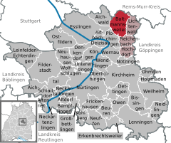  | ||
| Coordinates: 48°44′36″N 9°26′57″E / 48.74333°N 9.44917°ECoordinates: 48°44′36″N 9°26′57″E / 48.74333°N 9.44917°E | ||
| Country | Germany | |
| State | Baden-Württemberg | |
| Admin. region | Stuttgart | |
| District | Esslingen | |
| Government | ||
| • Mayor | Simon Schmid | |
| Area | ||
| • Total | 18.54 km2 (7.16 sq mi) | |
| Elevation | 453 m (1,486 ft) | |
| Population (2017-12-31)[1] | ||
| • Total | 5,734 | |
| • Density | 310/km2 (800/sq mi) | |
| Time zone | CET/CEST (UTC+1/+2) | |
| Postal codes | 73664–73666 | |
| Dialling codes | 07153 | |
| Vehicle registration | ES | |
| Website | www.baltmannsweiler.de | |

Baltmannsweiler is a municipality consisting of the two villages Baltmannsweiler and Hohengehren in the district of Esslingen in Baden-Württemberg, southern Germany.
Following local government reform in 1974, the municipality of Baltmannsweiler was created on January 1, 1975 by the consolidation of the previously independent villages of Baltmannsweiler and Hohengehren.
Local council (Gemeinderat)
Elections in May 2014: Seat distribution[2]
- Free voters: 3
- CDU: 3
- Alliance 90/The Greens: 3
- Unabhängige Bürger (Independent citizens): 2
- SPD: 2
- Neue Freie Liste (New free list): 1
References
- ↑ "Bevölkerung nach Nationalität und Geschlecht am 31. Dezember 2017". Statistisches Landesamt Baden-Württemberg (in German). 2018.
- ↑ Wahlinformationen des Kommunalen Rechenzentrums Stuttgart
| Authority control |
|---|
This article is issued from
Wikipedia.
The text is licensed under Creative Commons - Attribution - Sharealike.
Additional terms may apply for the media files.