Lefor, North Dakota
| Lefor | |
|---|---|
| Unincorporated community | |
 Lefor Location within the state of North Dakota  Lefor Lefor (the US) | |
| Coordinates: 46°40′54″N 102°33′35″W / 46.68167°N 102.55972°WCoordinates: 46°40′54″N 102°33′35″W / 46.68167°N 102.55972°W | |
| Country | United States |
| State | North Dakota |
| County | Stark |
| Elevation | 2,592 ft (790 m) |
| Time zone | UTC-6 (Central (CST)) |
| • Summer (DST) | UTC-5 (CDT) |
| ZIP codes | 58641 |
| Area code(s) | 701 |
| GNIS feature ID | 1029858 |
Lefor is an unincorporated community in southern Stark County, North Dakota, United States. It lies southeast of the city of Dickinson, the county seat of Stark County.[1] Its elevation is 2,592 feet (790 m).[2] Lefor's post office closed November 2, 2002,[3] but the town still has its own ZIP code of 58641.[4]
Lefor has the highest[5] percentage of residents of Hungarian origin of any zip code in the United States.
Lefor is part of the Dickinson Micropolitan Statistical Area.
Climate
This climatic region is typified by large seasonal temperature differences, with warm to hot (and often humid) summers and cold (sometimes severely cold) winters. According to the Köppen Climate Classification system, Lefor has a humid continental climate, abbreviated "Dfb" on climate maps.[6]
References
- ↑ Rand McNally. The Road Atlas '08. Chicago: Rand McNally, 2008, p. 77.
- ↑ U.S. Geological Survey Geographic Names Information System: Lefor, North Dakota, Geographic Names Information System, 1980-02-13. Accessed 2008-03-31.
- ↑ U.S. Postal Service Postmaster Finder: Post Offices by ZIP Code. Retrieved on July 12, 2008
- ↑ Zip Code Lookup
- ↑ Zip Codes with the Highest Percentage of Hungarians in the United States
- ↑ Climate Summary for Lefor, North Dakota
External links
- Lefor, ND : GhostsofNorthDakota.com (North Dakota's Ghost Towns and Abandoned Places)
- St. Elizabeth Parish (Roman Catholic)
- photo of St. Elizabeth's Church : The Queen of the Prarie - Lefor, North Dakota USA
Municipalities and communities of Stark County, North Dakota, United States | ||
|---|---|---|
| Cities | 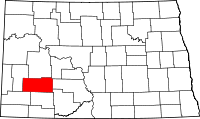 | |
| Unincorporated communities | ||