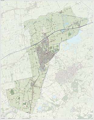
Leek, Netherlands
| Leek | |||
|---|---|---|---|
| Municipality | |||
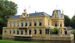 Nienoord castle | |||
| |||
.svg.png) Location in Groningen | |||
| Coordinates: 53°10′N 6°23′E / 53.167°N 6.383°ECoordinates: 53°10′N 6°23′E / 53.167°N 6.383°E | |||
| Country | Netherlands | ||
| Province | Groningen | ||
| Government[1] | |||
| • Body | Municipal council | ||
| • Mayor | Berend Hoekstra (VVD) | ||
| Area[2] | |||
| • Total | 64.28 km2 (24.82 sq mi) | ||
| • Land | 63.33 km2 (24.45 sq mi) | ||
| • Water | 0.95 km2 (0.37 sq mi) | ||
| Elevation[3] | 2 m (7 ft) | ||
| Population (August 2017)[4] | |||
| • Total | 19,672 | ||
| • Density | 311/km2 (810/sq mi) | ||
| Demonym(s) | Leker | ||
| Time zone | UTC+1 (CET) | ||
| • Summer (DST) | UTC+2 (CEST) | ||
| Postcode | 9350–9359, 9810–9819, 9827–9829 | ||
| Area code | 050, 0594 | ||
| Website |
leek | ||


Leek (Dutch pronunciation: [leːk] (![]()
The village is approximately 20 km west of Groningen (city) on the A7 (E22) highway.
The village grew around a fortification that was constructed here during the Eighty Years' War with Spain. The name 'Leek' was derived from a brook, the "Leke". The town is sometimes also called "De Leek". In Dutch, the people from Leek are called "Leeksters".
Every year around Pentecost there is a fair (Pinkstermarkt), drawing thousands of people from the area.
Near the village is a shallow lake, called "Het Leekstermeer" (also called Zulthemeer), with recreational facilities. Actually, the lake is in another municipality and in another province.
Attractions in the Leek Municipality
.jpg)
.jpg)

The main attraction in the village is the "Nienoord" estate. The estate was founded in 1508. After a destroying fire, a new manor-house was built in 1887. The gardens and the shell grotto were restored.
The National Carriage Museum is located in this manor-house. In 1958 the National Carriage Museum rented the house and gardens. The National Carriage Museum presents an overall view of the various types of carriages and sleighs from the 18th to the 20th century. The 250 coaches in the museum’s collection were used by farmers, the common man, noblemen and royalty.
In the estate is situated a recreation park (Family-park Nienoord) with model railways in several scales, including live steam.
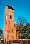
In Tolbert and Midwolde are churches from the 12th century. The churches are built in the Romano-Gothic style. Typical for this style are the walls and gables of brick that are richly decorated with recesses and patterns of bricks.
In the Church of Midwolda is a tomb monument sculpted by Rombout Verhulst. Rombout Verhulst also decorated the tomb of Michiel de Ruyter in the Nieuwe Kerk in Amsterdam.
Population centres
Enumatil, Leek, Lettelbert, Midwolde, Oostwold, Tolbert and Zevenhuizen.
References
- ↑ "Het college van burgemeester en wethouders" [The board of mayor and aldermen] (in Dutch). Gemeente Leek. Archived from the original on 1 February 2014. Retrieved 23 January 2014.
- ↑ "Kerncijfers wijken en buurten" [Key figures for neighbourhoods]. CBS Statline (in Dutch). CBS. 2 July 2013. Retrieved 12 March 2014.
- ↑ "Postcodetool for 9351BJ". Actueel Hoogtebestand Nederland (in Dutch). Het Waterschapshuis. Archived from the original on 21 September 2013. Retrieved 23 January 2014.
- ↑ "Bevolkingsontwikkeling; regio per maand" [Population growth; regions per month]. CBS Statline (in Dutch). CBS. 27 October 2017. Retrieved 27 October 2017.
External links
- Official website
- Carriage museum (Dutch & English)


Places adjacent to Leek, Netherlands | ||||||||||
|---|---|---|---|---|---|---|---|---|---|---|
| ||||||||||
