Lauterstein
| Lauterstein | ||
|---|---|---|
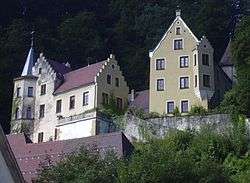 Castle of Lauterstein. | ||
| ||
 Lauterstein Location of Lauterstein within Göppingen district 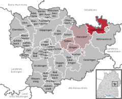  | ||
| Coordinates: 48°42′36″N 9°51′41″E / 48.71000°N 9.86139°ECoordinates: 48°42′36″N 9°51′41″E / 48.71000°N 9.86139°E | ||
| Country | Germany | |
| State | Baden-Württemberg | |
| Admin. region | Stuttgart | |
| District | Göppingen | |
| Government | ||
| • Mayor | Michael Lenz | |
| Area | ||
| • Total | 23.32 km2 (9.00 sq mi) | |
| Elevation | 468 m (1,535 ft) | |
| Population (2017-12-31)[1] | ||
| • Total | 2,586 | |
| • Density | 110/km2 (290/sq mi) | |
| Time zone | CET/CEST (UTC+1/+2) | |
| Postal codes | 73111 | |
| Dialling codes | 07332 | |
| Vehicle registration | GP | |
| Website | www.lauterstein.de | |

_und_Galgenberg.jpg)
Lauterstein
Lauterstein is a town in the district of Göppingen in Baden-Württemberg in southern Germany. It is located 15 km east of Göppingen, and 11 km southeast of Schwäbisch Gmünd.
References
- ↑ "Bevölkerung nach Nationalität und Geschlecht am 31. Dezember 2017". Statistisches Landesamt Baden-Württemberg (in German). 2018.
This article is issued from
Wikipedia.
The text is licensed under Creative Commons - Attribution - Sharealike.
Additional terms may apply for the media files.