Drackenstein
| Drackenstein | ||
|---|---|---|
| ||
 Drackenstein Location of Drackenstein within Göppingen district 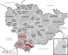  | ||
| Coordinates: 48°33′25″N 9°40′43″E / 48.55694°N 9.67861°ECoordinates: 48°33′25″N 9°40′43″E / 48.55694°N 9.67861°E | ||
| Country | Germany | |
| State | Baden-Württemberg | |
| Admin. region | Stuttgart | |
| District | Göppingen | |
| Government | ||
| • Mayor | Klaus-Dieter Apelt | |
| Area | ||
| • Total | 5.69 km2 (2.20 sq mi) | |
| Elevation | 729 m (2,392 ft) | |
| Population (2017-12-31)[1] | ||
| • Total | 419 | |
| • Density | 74/km2 (190/sq mi) | |
| Time zone | CET/CEST (UTC+1/+2) | |
| Postal codes | 73345 | |
| Dialling codes | 07335 | |
| Vehicle registration | GP | |

Drackenstein is a municipality in the district of Göppingen in Baden-Württemberg in southern Germany.
Geographical location
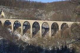
Drackenstein is located on the slope between the Gosbach valley and the plateau of the Swabian Jura, about 25 km away from the district town Göppingen. On the plateau of the Swabian Jura, (karst mountains), in earlier times water was a precious commodity. Therefore, there was in Unterdrackenstein a Hydraulic ram, that pumped water to Oberdrackenstein. By connecting to the Lake Constance water supply in the 20th century these problems belong to the past. At the opposite Drackensteiner Hang the Bundesautobahn 8 runs towards Stuttgart. There was the dragon hole, a cavity, which was filled in during the construction of the motorway.[2] It is believed that the name of the community goes back to a legend of the dragon hole.
Neighboring communities
The municipality borders on Bad Ditzenbach, in the southeast on Merklingen, in the southwest on Hohenstadt and in the west on the town Wiesensteig and the municipality Mühlhausen im Täle. Merklingen belongs to Alb-Donau-district, all others to Göppingen district.
Municipality arrangement
The municipality includes the village Oberdrackenstein, the hamlet Unterdrackenstein and the homestead Kölleshof.[3]
History
Drackenstein was first documented in a chronicle of the Zwiefalten Abbey from the year 1137. See also: Castle Drackenstein
Population Development
The inhabitants of the community development 1837-2010.
- Date Population
- 1837 257
- 1907 252
- May 17, 1939 305
- September 13, 1950 417
- May 27, 1970 310
- December 31, 1983 346
- December 31, 2000 432
- December 31, 2005 431
- December 31, 2010 437
References
- ↑ "Bevölkerung nach Nationalität und Geschlecht am 31. Dezember 2017". Statistisches Landesamt Baden-Württemberg (in German). 2018.
- ↑ http://www.drackenstein.de/index.php?id=7
- ↑ Das Land Baden-Württemberg. Amtliche Beschreibung nach Kreisen und Gemeinden. Band III: Regierungsbezirk Stuttgart, Regionalverband Mittlerer Neckar. Kohlhammer, Stuttgart 1978, ISBN 3-17-004758-2. S. 347–348