Lauada, North Carolina
| Lauada, North Carolina | |
|---|---|
| Unincorporated community | |
 Lauada, North Carolina  Lauada, North Carolina | |
| Coordinates: 35°22′22″N 83°30′15″W / 35.37278°N 83.50417°WCoordinates: 35°22′22″N 83°30′15″W / 35.37278°N 83.50417°W | |
| Country | United States |
| State | North Carolina |
| County | Swain |
| Elevation | 1,959 ft (597 m) |
| Time zone | UTC-5 (Eastern (EST)) |
| • Summer (DST) | UTC-4 (EDT) |
| Area code(s) | 828 |
| GNIS feature ID | 1012685[1] |
Lauada is an unincorporated community in Swain County, North Carolina, United States. Lauada is located at the junction of U.S. Route 19, U.S. Route 74, and North Carolina Highway 28 5.1 miles (8.2 km) southwest of Bryson City.
The Swain Center, a satellite location of Southwestern Community College, is located here.
References
Municipalities and communities of Swain County, North Carolina, United States | ||
|---|---|---|
| Town | 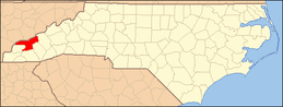 | |
| CDP | ||
| Unincorporated communities | ||
| Indian reservation | ||
| Footnotes | ‡This populated place also has portions in an adjacent county or counties | |
This article is issued from
Wikipedia.
The text is licensed under Creative Commons - Attribution - Sharealike.
Additional terms may apply for the media files.