Latronico
| Latronico | |
|---|---|
| Comune | |
| Comune di Latronico | |
 | |
 Latronico Location of Latronico in Italy | |
| Coordinates: 40°5′N 16°1′E / 40.083°N 16.017°ECoordinates: 40°5′N 16°1′E / 40.083°N 16.017°E | |
| Country | Italy |
| Region | Basilicata |
| Province | Potenza (PZ) |
| Frazioni | Agromonte Magnano, Agromonte Mileo, Battista, Calda, Cerri, Fraccia-Laghi, Iannazzo, Ischitelli, Lucarelli, Mastroluca, Masullo, Pargo, Pantoni, Papaleo, Perosa, Perricchio, Preti, Procoio, Serrone, Varrazzo |
| Area | |
| • Total | 75 km2 (29 sq mi) |
| Elevation | 888 m (2,913 ft) |
| Population (December 2008)[1] | |
| • Total | 4,906 |
| • Density | 65/km2 (170/sq mi) |
| Demonym(s) | Latronichesi |
| Time zone | UTC+1 (CET) |
| • Summer (DST) | UTC+2 (CEST) |
| Postal code | 85043 |
| Dialing code | 0973 |
| ISTAT code | 076040 |
| Patron saint | Sant'Egidio |
| Saint day | 1 September |
| Website | Official website |
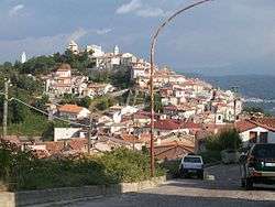
Latronico (Latronichese: Latruonicu) is a town and comune in the province of Potenza, in the Southern Italian region of Basilicata. Due to its high elevation of 888 metres (2,913 ft) it is much cooler, even in summer, than the larger cities along the coasts.[2]
References
- ↑ All demographics and other statistics from the Italian statistical institute (Istat)
- ↑ http://www.weatherbase.com/weather/weather.php3?s=163160

This article is issued from
Wikipedia.
The text is licensed under Creative Commons - Attribution - Sharealike.
Additional terms may apply for the media files.