Lagonegro
| Lagonegro | ||
|---|---|---|
| Comune | ||
| Comune di Lagonegro | ||
 | ||
| ||
.svg.png) Lagonegro within the Province of Potenza | ||
 Lagonegro Location of Lagonegro in Italy | ||
| Coordinates: 40°8′N 15°46′E / 40.133°N 15.767°ECoordinates: 40°8′N 15°46′E / 40.133°N 15.767°E | ||
| Country | Italy | |
| Region | Basilicata | |
| Province | Potenza (PZ) | |
| Frazioni | Casale Serino, Cervaro, Farno, Fecìla, Fortino, Malpignata, Pennarone, Strette | |
| Government | ||
| • Mayor | Pasquale Mitidieri | |
| Area | ||
| • Total | 113.07 km2 (43.66 sq mi) | |
| Elevation | 666 m (2,185 ft) | |
| Population (31 December 2017)[1] | ||
| • Total | 5,442 | |
| • Density | 48/km2 (120/sq mi) | |
| Demonym(s) | Lagonegresi | |
| Time zone | UTC+1 (CET) | |
| • Summer (DST) | UTC+2 (CEST) | |
| Postal code | 85042 | |
| Dialing code | 0973 | |
| Patron saint | St. Nicholas of Bari | |
| Saint day | 6 December | |
| Website | Official website | |

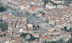
Lagonegro (Lucano: Launìvere) is a town and comune in the province of Potenza, in the Southern Italian region of Basilicata. It is part of the Valle del Noce and has (2017) a population of 5,471. [1]
Geography
The municipality, located southwest of its province, near the borders of Basilicata with Cilento, a subregion of Campania, is bordered by the municipalities of Casalbuono, Casaletto Spartano, Lauria, Moliterno, Montesano sulla Marcellana, Nemoli, Rivello and Tortorella.[2] It counts the hamlets (frazioni) of Casale Serino, Cervaro, Farno, Fecìla, Fortino, Malpignata, Pennarone and Strette.
Transport
The town is served by two exits ("Lagonegro Nord" and "Lagonegro Sud") of the A2 motorway, linking Naples and Salerno to Cosenza, Lamezia and Reggio Calabria. Its railway station is the terminus of 2 abandoned lines using two different gauges: the standard gauge line Sicignano–Lagonegro, and the narrow gauge line Lagonegro–Castrovillari–Spezzano Albanese.
People
- Tiziana Alagia (b. 1973), long distance runner
- Giuseppe Mango (1954-2014), singer
See also
References
External links
| Wikimedia Commons has media related to Lagonegro. |
