Lastra a Signa
| Lastra a Signa | ||
|---|---|---|
| Comune | ||
| Comune di Lastra a Signa | ||
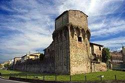 Walls of Lastra a Signa | ||
| ||
 Lastra a Signa Location of Lastra a Signa in Italy | ||
| Coordinates: 43°46′N 11°6′E / 43.767°N 11.100°E | ||
| Country | Italy | |
| Region | Tuscany | |
| Metropolitan city | Florence (FI) | |
| Frazioni | Belfiore, Bracciatica, Brucianesi, Calcinaia, Carcheri, Ginestra Fiorentina, Inno, La Lisca, La Luna, Lecceto, Malmantile, Marliano, Ponte a Signa, Ponte Torto, Porto di Mezzo, Quattro Strade, San Martino a Gangalandi, San Romolo, Sant'Ilario a Settimo, Stagno, Val di Rose. | |
| Government | ||
| • Mayor | Angela Bagni | |
| Area | ||
| • Total | 43.1 km2 (16.6 sq mi) | |
| Elevation | 36 m (118 ft) | |
| Population (31 August 2017)[1] | ||
| • Total | 20,252 | |
| • Density | 470/km2 (1,200/sq mi) | |
| Demonym(s) | Lastrigiani | |
| Time zone | UTC+1 (CET) | |
| • Summer (DST) | UTC+2 (CEST) | |
| Postal code | 50055 | |
| Dialing code | 055 | |
| Patron saint | St. Martin of Tours | |
| Saint day | November 11 | |
| Website | Official website | |

Lastra a Signa is a comune (municipality) in the metropolitan city of Florence in the Italian region Tuscany, located about 12 kilometres (7 mi) west of Florence.
Main sights
- Hospital of Sant'Antonio (1411)
- "Brunelleschi" Walls, although the attribution to the Florentine architect is uncertain
Twin towns
Lastra a Signa is twinned with:


References
External links
| Wikimedia Commons has media related to Lastra a Signa. |

This article is issued from
Wikipedia.
The text is licensed under Creative Commons - Attribution - Sharealike.
Additional terms may apply for the media files.