Lapid
| Lapid לַפִּיד | |
|---|---|
 Lapid | |
| Coordinates: 31°54′59.39″N 35°1′59.15″E / 31.9164972°N 35.0330972°ECoordinates: 31°54′59.39″N 35°1′59.15″E / 31.9164972°N 35.0330972°E | |
| District | Central |
| Council | Hevel Modi'in |
| Founded | 1996 |
| Population (2017)[1] | 2,485 |
Lapid (Hebrew: לַפִּיד, lit. Torch) is an Israeli community settlement. Located in the Latrun Salient of the Green Line near Modi'in, it falls under the jurisdiction of Hevel Modi'in Regional Council. In 2017 it had a population of 2,485.[1]
History
Lapid was established in 1996. According to Btselem, it was built on a strip of land designated no man's land inside the Green Line. Before the Six-Day War in 1967, this territory did not belong to either Jordan or Israel.[2]
According to ARIJ, Israel confiscated 441 dunam of land from the Palestinian village of Saffa after 1967 for the construction of Lapid.[3]
References
- 1 2 "List of localities, in Alphabetical order" (PDF). Israel Central Bureau of Statistics. Retrieved August 26, 2018.
- ↑ Land grab: Israel's Settlement Policy in the West Bank Btselem
- ↑ Saffa village profile, ARIJ, p. 17
External links
- Lapid website (in Hebrew)
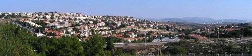
View of Lapid and Kfar HaOranim
This article is issued from
Wikipedia.
The text is licensed under Creative Commons - Attribution - Sharealike.
Additional terms may apply for the media files.