Hadid
| Hadid חָדִיד | |
|---|---|
 | |
 Hadid | |
| Coordinates: 31°58′3.72″N 34°56′0.95″E / 31.9677000°N 34.9335972°ECoordinates: 31°58′3.72″N 34°56′0.95″E / 31.9677000°N 34.9335972°E | |
| District | Central |
| Council | Hevel Modi'in |
| Affiliation | Hapoel HaMizrachi |
| Founded | 1950 |
| Founded by | Yemenite immigrants |
| Population (2017)[1] | 888 |
| Website | www.hadid.co.il |
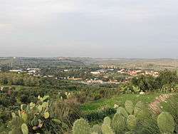
Hadid (Hebrew: חָדִיד) is a moshav in central Israel. Located near Modi'in, it falls under the jurisdiction of Hevel Modi'in Regional Council. In 2017 it had a population of 888.[1]
History
Hadid was a city of the tribe of Benjamin in Biblical times.[2][3] In the Hellenistic era it was known as 'Adida. Hadid was founded in 1949 as a kibbutz by Yemenite Jewish immigrants, later joined by immigrants from Romania. In 1950, it was reorganized as a moshav affiliated with the Hapoel HaMizrachi movement.[4] The site was about 2km west of the former Palestinian village site and on the land of al-Haditha and the archaeological tel of ancient Hadid.[5]
According to the Mishnah, the town of Hadid was encompassed by a wall before the Israelite conquest of Canaan under Joshua.[6]
Archaeology
In 2008, an archaeological excavation was conducted by Hagit Torgë at Tel Hadid which yielded scant remains and a building from the Iron Age and the early Persian period.[7]
References
- 1 2 "List of localities, in Alphabetical order" (PDF). Israel Central Bureau of Statistics. Retrieved August 26, 2018.
- ↑ Ezra 2,33; Nehemiah 11,34
- ↑ Carta's Official Guide to Israel and Complete Gazetteer to all Sites in the Holy Land. (3rd edition 1993) Jerusalem, Carta, p.179, ISBN 965-220-186-3.
- ↑ Hadid website
- ↑ Carta's Official Guide to Israel and Complete Gazetteer to all Sites in the Holy Land
- ↑ The Mishnah, (ed.) Herbert Danby, Arakhin 9:6 (p. 553 - note 13)
- ↑ IAA Report: Tel Hadid