Lap Corner, Indiana
| Lap Corner | |
|---|---|
| Unincorporated community | |
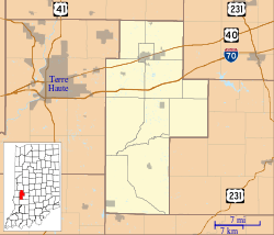 Lap Corner Location in Clay County | |
| Coordinates: 39°25′51″N 87°04′18″W / 39.43083°N 87.07167°WCoordinates: 39°25′51″N 87°04′18″W / 39.43083°N 87.07167°W | |
| Country | United States |
| State | Indiana |
| County | Clay |
| Township | Sugar Ridge |
| Elevation | 673 ft (205 m) |
| GNIS feature ID | 437627[1] |
Lap Corner is an unincorporated community in northern Sugar Ridge Township, Clay County, Indiana, just north of Center Point. It is part of the Terre Haute Metropolitan Statistical Area.
Geography
Lap Corner is located at 39°25′51″N 87°04′18″W / 39.43083°N 87.07167°W.
References
- ↑ "Lap Corner, Indiana". Geographic Names Information System. United States Geological Survey. Retrieved 2009-10-10.
Municipalities and communities of Clay County, Indiana, United States | ||
|---|---|---|
| City | ||
| Towns | ||
| Townships | ||
| CDP | ||
| Other unincorporated communities |
| |
| Ghost towns | ||
| Footnotes | ‡This populated place also has portions in an adjacent county or counties | |
This article is issued from
Wikipedia.
The text is licensed under Creative Commons - Attribution - Sharealike.
Additional terms may apply for the media files.