Lambs Lane, Lawshall
| Lambs Lane | |
|---|---|
 The Glebe residential development | |
 Lambs Lane Lambs Lane shown within Suffolk | |
| District | |
| Shire county | |
| Region | |
| Country | England |
| Sovereign state | United Kingdom |
| Post town | Bury St Edmunds |
| Postcode district | IP29 |
| EU Parliament | East of England |
Lambs Lane is a nuclear settlement in the civil parish of Lawshall in the Babergh district in the county of Suffolk, England. In addition to Lambs Lane, the settlement includes The Glebe, Shepherds Drive, Windsor Drive, Churchill Close and Rectory Corner. Melford Road is partly within Lambs Lane and Golden Lane is to the west of the settlement.
Lambs Lane is located between Harrow Green, which it almost abuts, and Brockley to the west, and is around one and a half miles off the A134 between Bury St Edmunds and Sudbury.
Previous names
In the 1567 Lawshall Survey, Melford Road was known as Chardakre Street and Rectory Corner as the Parson's Green. Golden Lane was known as Goldesborowe Street.[1]
Lawshall Village Hall
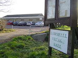
Lawshall Village Hall was built in the 1960s replacing the old village hall that stood in the Street. In December 2006 the Village Hall Management Committee started organising events to raise money to update and refurbish the hall. A variety of events were organised and grants were also obtained. The result was that by the end of 2007 the Committee were in a position to start work on a major refurbishment scheme which together cost around £47,000. Improvements include:
- Completely new floor and flat roof replaced
- New toilets including facilities for the disabled
- Two new small meeting rooms
- New comfortable chairs and folding plastic topped tables
- Full sound system and hearing loop installed
- Refurbished stage and curtains with a small 'Green Room'[2]
The Village Hall Management Committee produce the monthly magazine Round & About Lawshall. A free copy is delivered to every household in the village.[3]
Village shop
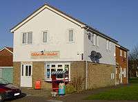
Lawshall has one village shop, known as The Glebe Mini Market, that is located in The Glebe at Lambs Lane. As the population of the parish grew in the nineteenth century the number of shops serving the expanding community increased from 2 shops in 1844 to 6 shops in 1883. In 1937 there were still 6 shops although there had been reductions in the number in the 1920s.[4] In the 1990s there were 2 shops in the village, the Glebe Stores and the Post Office, which reduced to one shop after the millennium and then following the closure of the Glebe Stores the village did not have a shop for a number of years.
This position changed in 2010 following the re-opening of the store on The Glebe as The Glebe Mini Market which offers groceries, newspapers, an off-licence and a range of DIY hardware to the local community. The shop unit was created as part of the housing development on The Glebe in the 1970s and for a long time was known as the Mace Shop. The shop was run by John Smith and later became known as the Glebe Stores.[1]
King William Inn
Windsor House in Bury Road was formally the King William Public House which closed in the 1940s. In the Suffolk Free Press on 27 September 1945 it was reported that Mr Talbott of Loft Farm, Bradfield Combust and landlord of the King William Inn had died.[5]
It is not possible to provide a complete list of all the publicans (and residents) of the King William or the verified dates when they took over or left the public house. However, with reference to the Official Census, White's Directory, Post Office Directory and other sources the following list is provided:[6]
| Year(s) | Publicans (and residents) |
|---|---|
| 1871 | George Nunn |
| 1879-91 | Meshack Sergeant |
| 1911-16 | Benjamin Talbott |
Listed buildings
English Heritage does not list any Listed buildings within the settlement of Lambs Lane itself, but there are two listings to the south in Melford Road:
- Dales Farmhouse - British Listed Buildings
- Little West Farm - British Listed Buildings[7][8][9]
NB: The above property details usually represent the names and addresses that were used at the time that the buildings were listed. In some instances the name of the building may have changed over the intervening years.
Gallery
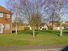
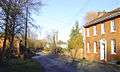 The edge of the Lambs Lane settlement.
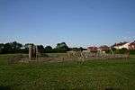 Lawshall Community Playground.
References
- 1 2 Lawshall Parish Council, ed. (2006). Lawshall: A Guide to Your Village. Lawshall Parish Council. p. 16.
- ↑ "Lawshall Village Hall". Village Hall Management Committee. Retrieved 2012-02-03.
- ↑ "Lawshall Village Hall". Lawshall Parish Council. Archived from the original on 20 October 2011. Retrieved 3 February 2012.
- ↑ Lawshall Village Appraisal Group, ed. (1991). Lawshall: Past, Present and Future – An Appraisal. Appraisal Group.
- ↑ "1945 Suffolk Free Press newspaper archive". Foxearth and District Local History Society. Retrieved 2012-02-07.
- ↑ "The Suffolk Real Ale Guide - King William". Suffolk CAMRA. Retrieved 2012-02-07.
- ↑ "Listed Buildings Online - English Heritage". Archived from the original on 25 September 2005. Retrieved 2012-01-13.
- ↑ "Heritage Gateway". Retrieved 2012-02-03.
- ↑ "Lawshall - British Listed Buildings". Retrieved 2012-01-13.
External links
| Wikimedia Commons has media related to Lawshall. |
- Lawshall Archives Group
- Geograph: Pictures of Lawshall & environs
- Map showing Lambs Lane, Lawshall on streetmap.co.uk
- A Vision of Britain Through Time - Boundary Map of Lawshall