Lakshmipur Adarsha Samad Government High School
| Lakshmipur Adarsha samad government high School লক্ষ্মীপুর আদর্শ সামাদ সরকারি উচ্চ বিদ্যালয় | |
|---|---|
 Official logo | |
| Location | |
SR road,Lakshmipur Sadar Upazila , Lakshmipur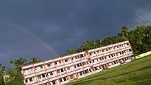 schools photo Chittagong, 3700 Bangladesh | |
| Information | |
| Other name | সামাদ স্কুল। |
| Former name | মডেল হাই স্কুল & সামাদ একাডেমী |
| Type | Government |
| Motto | পড় তোমার প্রভুর নামে |
| Religious affiliation(s) | ইসলাম ও সনাতন |
| Established | 1887 |
| Founded | 1887 |
| Sister school | Lakshmipur Town Primary School and Eidgah Primary School |
| School board | Board of Intermediate and Secondary Education, Comilla |
| School number | 0381-55426 |
| School code | 7025 |
| Headmaster | Abdul Motin |
| Head teacher | Abdul Motin |
| Staff | 75 |
| Faculty | 70 |
| Teaching staff | 60 |
| Key people | Shafiqul Alam, Prabir Narayan, Uttom Kumar Voumik, Abdul Motin sir |
| Grades | 1 to 10 |
| Years offered | 1887-present |
| Gender | Male |
| Age range | 5-18 |
| Enrollment | 2000+ |
| Student to teacher ratio | 26:1 |
| Medium of language | Bangla |
| Schedule type | Morning shift & Day shiht |
| Schedule | (9 am-1 pm) & (12-4) pm |
| Hours in school day | 4 Hours |
| Classrooms | 40 |
| Color(s) | White shirt & Navy blue pants |
| Sports | Cricket, Football, Badminton, Basketball, Swimming, Handball, Sprint. |
| USNWR ranking | 1 |
| National ranking | 897 |
| Publication | সামাদ সাময়িকী। |
| Alumni | Mohammad Mohammadullah, Mohammad Toaha, Shahid uddin Chowdhury Anny, A.K.M. Shahjahan Kamal,Abul Ahsan, Ramendu Majumdar |
Lakshmipur Adarsha samad government high School (Bengali: লক্ষীপুর আদর্শ সামাদ সরকারি উচ্চ বিদ্যালয়) is a boys' high school located in Lakshmipur, Bangladesh. It is one of the oldest schools in the country. The school was established in 1887 Lakshmipur Sadar Upazila, Bangladesh.[1] It was established in 1886[2] by the summit of local advocates and authorised by the university of Kolkata The school is under the Board of Intermediate and Secondary Education, Comilla.
References
- ↑ "All Schools in Lakshmupur" (PDF). deo.lakshmipur.gov.bd. Retrieved 17 October 2016.
- ↑ Mahmud, Nazimuddin (2012). "Lakshmipur Sadar Upazila". In Islam, Sirajul; Jamal, Ahmed A. Banglapedia: National Encyclopedia of Bangladesh (Second ed.). Asiatic Society of Bangladesh.
Coordinates: 22°56′03″N 90°49′50″E / 22.9342°N 90.8305°E
This article is issued from
Wikipedia.
The text is licensed under Creative Commons - Attribution - Sharealike.
Additional terms may apply for the media files.