Lake Pend Oreille
| Lake Pend Oreille | |
|---|---|
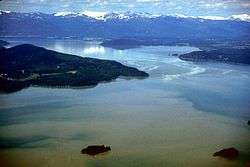 Aerial view in 1993 | |
 Lake Pend Oreille  Lake Pend Oreille | |
| Location | Bonner / Kootenai counties, Idaho, U.S. |
| Coordinates | 48°10′0″N 116°20′0″W / 48.16667°N 116.33333°WCoordinates: 48°10′0″N 116°20′0″W / 48.16667°N 116.33333°W |
| Primary inflows |
Clark Fork River, Pack River, Trestle Creek |
| Primary outflows |
Pend Oreille River, Spokane Valley–Rathdrum Prairie Aquifer |
| Basin countries | United States |
| Max. length | 43 miles (69 km) |
| Surface area | 148 square miles (380 km2) |
| Max. depth | 1,150 feet (351 m) |
| Surface elevation | 2,062 feet (628 m) |
| Trenches | Purcell |
| Settlements | Sandpoint |
Lake Pend Oreille ( /pɒndəˈreɪ/)[1] in the northern Idaho Panhandle is the largest lake in the U.S. state of Idaho and the 38th-largest lake by area in the United States, with a surface area of 148 square miles (380 km2). It is 43 miles (69 km) long, and 1,150 feet (350 m) deep in some regions, making it the fifth-deepest in the nation. It is fed by the Clark Fork River and the Pack River, and drains via the Pend Oreille River.
It is surrounded by national forests and a few small towns, with the largest population on the lake at Sandpoint. The majority of the shoreline is non-populated and all but the southern tip of the lake is in Bonner County. The southern tip is in Kootenai County and is home to Farragut State Park, formerly the Farragut Naval Training Station during World War II, of which a small part is still active and conducts U.S. Navy acoustic underwater submarine research.[2][3]
The surrounding forests consist of ponderosa pine, Douglas fir, red cedar, poplar, quaking aspen, hemlock, paper birch and western larch.[4][5] Local animal species include white-tailed deer, elk, gray wolves, moose, mice, squirrels, black bears, grizzly bear, coyotes, and bobcats, along with bald eagles, osprey, owls, hummingbirds, hawks, woodpeckers, ducks, and the mountain bluebird. The lake is a home for several species of migratory water fowl.
History
%2C_Sea_Jet%2C_undergoes_sea_trials_on_Lake_Pend_Oreille_at_the_Naval_Surface_Warfare_Center_Carderock_Division%2C_Acoustic_Research_Detachment_in_Bayview%2C_Idah.jpg)
Lake Pend Oreille was glacially formed during the ice age. It is also believed that the eastern side of the lake was in the path of the ancient Missoula Flood. The lake sits at the south end of the Purcell Trench,[6] carved by glaciers moving south from Canada. The eastern side of the glacier is believed to have formed the dam for the Missoula flood, at the point where the Clark Fork river enters the lake between the Cabinet and Bitterroot mountains. The lake is made slightly larger by the dam at Albeni Falls, just east of Oldtown; the dam is ninety feet (27 m) high and operated by the U.S. Army Corp of Engineers. Along with Crater Lake, Lake Tahoe, Lake Chelan, and Lake Superior, Lake Pend Oreille is among the five deepest lakes in the United States.
The area around the lake is the traditional home of the Kalispel Indian peoples. David Thompson established a North West Company trading post on the lake in 1809. A Canadian fur trader in Thompson's party is believed to have given the lake its name. The words "Pend Oreille" are French for an ear-hanging or pendant. Ear pendants were characteristic of the Kalispel tribe. The lake is shaped much like a human ear when viewed from above or on a map.
During World War II, the south end was the second largest naval training ground in the world and the largest "city" in the state. Built as a result of the Japanese attack on Pearl Harbor, the training station is now Farragut State Park. The lake's Large Scale Vehicle Range is still used by the Navy's Acoustic Research Detachment for sonar testing with large-scale submarine prototypes on the Pend Oreille Calibration Station. The significant depth gives acoustic properties similar to the open ocean.[7] Background noise is less than at ocean testing locations, and the sound signatures being investigated cannot be monitored by foreign governments in international waters.[8][9]
In 1967, the former Farragut Naval Training Station was used to accommodate the 12th World Scout Jamboree (1st to 8th August), the dates being significant as it marked 60 years to the date after Sir Robert Baden Powell held his first scout camp on Brownsea Island in Poole Harbour, Dorset in England.
Other information
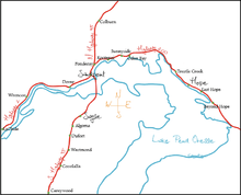
The following towns are adjacent to the lake:
The lake is viewed from the Pend Oreille Scenic Byway, State Highway 200 along the north shore. Much of the shore is mountainous. The mountains to the east are the Green Monarchs; to the north are the Cabinet Mountains; to the southwest the Coeur d'Alene Mountains; and to northwest are the Selkirk Mountains.
Geology
For more information on the geology of Lake Pend Oreille see
- http://imnh.isu.edu/digitalatlas/counties/bonner/geomap.htm
- http://imnh.isu.edu/digitalatlas/counties/kootenai/geomap.htm
- Alt, David. Glacial Lake Missoula and Its Humongous Floods. Missoula, MT: Mountain Press Publishing Co., 2001
Aquatic invasive species
Bonner County Public Works oversees Eurasian Milfoil treatment in Lake Pend Oreille. A group of Sandpoint moms, Mothers for Safe Water is concerned about this use of herbicides to treat milfoil.
Fish
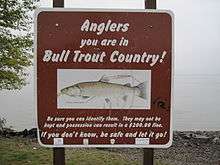
The lake is home to many species of fish, including rainbow trout, lake trout, perch, black crappie, largemouth bass, smallmouth bass, whitefish, walleye, northern pike and kokanee. Lake Pend Oreille is also the home of the 37-pound (17-kilogram) state record Kamloops rainbow trout caught by Wes Hamlet in 1947.
- Idaho Fish and Game
- Lake Pend Oreille Idaho Club volunteer, nonprofit interested in kokanee survival for the benefit of restoring the Gerrard Rainbow fishery. The club's primary goal is to protect and enhance Lake Pend Oreille.
Conservation
- Pend Oreille Basin Commission formed to oversee any issues relating to water quality and/or water quantity in Lake Pend Oreille, Pend Oreille River, Priest Lake and Priest River Basin
- Tri-State Water Quality Council Citizens, business, industry, tribes, government and environmental groups combined to oversee the Clark Fork-Pend Oreille river system
- Kaniksu Land Trust non-profit land trust serving Sanders County, Montana and Bonner County, Idaho
- Inland Northwest Land Conservancy non-profit land trust serving eastern Washington and northern Idaho
- Idaho Department of Environmental Quality Lake Pend Oreille Watershed Advisory Group
- Rock Creek Alliance nonprofit works to protect the water quality of the Clark Fork-Pend Oreille Watershed and the Cabinet Mountains Wilderness Area (primarily from contamination from the mining industry)
- Lake Pend Oreille Waterkeeper environmental group part of the larger Waterkeeper Alliance
See Also
References
- ↑
- ↑ http://articles.latimes.com/1998/aug/23/local/me-15711
- ↑ "Archived copy". Archived from the original on 2013-03-13. Retrieved 2013-02-06.
- ↑ http://www.fs.usda.gov/photogallery/ipnf/learning/nature-science/gallery/?cid=1185&position=Quicklinks
- ↑ http://www.idahoforests.org/trees1.htm
- ↑ http://bulletin.geoscienceworld.org/cgi/content/abstract/112/9/1356
- ↑ "Archived copy". Archived from the original on 2008-02-01. Retrieved 2008-02-03.
- ↑ Rogoway, Tyler. "The Navy's Most Vital And Secretive Submarine Base Is In... Idaho?!?". Foxtrot Alpha. Retrieved 24 April 2018.
- ↑ "Acoustic Research Detachment - Bayview, Idaho". Naval Sea Systems Command. United States Navy. Retrieved 24 April 2018.
- Alvarez, Gail E.; Woolford, Dennis (2009). Farragut Naval Training Station. Charleston, SC: Arcadia Pub. ISBN 978-0-7385-7096-9.
External links
| Wikimedia Commons has media related to Lake Pend Oreille. |
- Idaho State Parks - official site - Farragut
- Idaho Public TV - Lake Pend Oreille
- U.S. Navy - Acoustic Research Detachment - Bayview, Idaho
- Global Security.org - U.S. Navy ARD - Bayview, Idaho
- Nav Source.org - photos of LSV-2 Cutthroat - Navy ARD - Bayview, ID
- Lake Pend Oreille Weather Buoy - U.S. Navy
- Idaho Scenic Byways
- - Lake Pend Oreille Vacation Rentals - Sandpoint, Idaho