Spokane Valley–Rathdrum Prairie Aquifer
| Spokane Valley–Rathdrum Prairi Aquifer | |
|---|---|
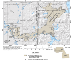 Map of the Aquifer | |
| Location | United States |
| Primary inflows |
|
| Primary outflows | Spokane River |
| Surface area | 370 square miles (960 km2) |
| Water volume | 10 trillion gallons (12,000 km3) |
The Spokane Valley–Rathdrum Prairie Aquifer is an aquifer located in the U.S. states of Washington and Idaho It is located under the city of Spokane, as well as under the Spokane Valley, and the Rathdrum Prairie. The aquifer contains 10 trillion gallons (38 trillion liters) of water, and is part of the Columbia River Drainage Basin. The only watercourse that remains above the surface for an extended distance is the Spokane River. The area surrounding it receives an average of 13–30 inches (33–76 cm) of rain annually. The aquifer is the primary water source for the greater Spokane area, which is home to over 700,000 people.[1]
References
- ↑ "The Spokane Valley–Rathdrum Prairie Aquifer Atlas" (PDF). Spokane Aquifer Joint Board. Retrieved 2016-09-05.
This article is issued from
Wikipedia.
The text is licensed under Creative Commons - Attribution - Sharealike.
Additional terms may apply for the media files.