Lake Mégantic
| Lake Mégantic Lac Mégantic | |
|---|---|
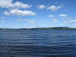 Lake Mégantic in Piopolis | |
| Location | Le Granit Regional County Municipality, Estrie, Quebec, Canada |
| Coordinates | 45°30′50″N 70°52′38″W / 45.51389°N 70.87722°WCoordinates: 45°30′50″N 70°52′38″W / 45.51389°N 70.87722°W |
| Type | Glacial lake |
| Primary inflows | Arnold River |
| Primary outflows | Chaudière River |
| Basin countries | Canada |
| Max. length | 16 kilometres (9.9 mi) |
| Max. width | 3.5 kilometres (2.2 mi) |
| Surface area | 26.4 square kilometres (10.2 sq mi) |
| Average depth | 75 m (246 ft) |
| Shore length1 | 45.4 km (28.2 mi) |
| Surface elevation | 395 metres (1,296 ft) |
| Settlements | Lac-Mégantic, Frontenac, Marston, and Piopolis |
| 1 Shore length is not a well-defined measure. | |
Lake Mégantic (French: Lac Mégantic) is a body of water in Québec, located in the Appalachian Mountains near the U.S. border. It is a source of the Chaudière River which drains into the St Lawrence River at Québec City. The name Mégantic means 'where the fish gather' in the Abénaquis language.[1] The lake has a surface area of 26.4 km2 (10.2 sq mi) with several villages and small towns on its shores, including Lac-Mégantic, Frontenac, Marston, and Piopolis. It is part of Le Granit Regional County Municipality, a rural region where forestry and granite extraction are important activities.[2]
Name
Two origins for the name "Mégantic" have been proposed. The first is that the lake name originates from an unspecified native language, "mékwawatíhk" meaning "Mohawk Road". The other is that the name was given by the early Scottish settlers, originally rendered something like "MooseTookmegunTic Lake", English mimicry of the Native American grammar of place names: "moose-look-me-gun-kick". The story being that "the moose only looked at me and my gun kicked -- the Indians meant he never got the moose".[3]
Physical geography
The water surface is 395 m (1,296 ft) above mean sea level and the lake has an average depth of 75 m (246 ft); its total surface area is 26.4 square kilometres (10.2 sq mi), with a total shoreline of 45.4 km (28.2 mi).[4] Its length is about 16 km (9.9 mi) and it has an average width of 3.5 km (2.2 mi).[1][5]
European settlement
Settlement under the French régime was sparse. It was not until the 19th century that significant numbers of settlers arrived, including many Scots who had been forced to leave their ancestral home in the Highlands.[1]
References
- 1 2 3 "Mégantic Lake". Local Development Centre (CLD) of the MRC du Granit. Retrieved 12 July 2013.
- ↑ MRC du Granit, http://www.mrcgranit.qc.ca/
- ↑ Harrington, John Peabody. (1949-circa 1952). John Peabody Harrington papers: Western Abnaki/Eastern Abnaki/Passamaquoddy. In John Peabody Harrington papers: Northeast/Southeast, 1907-1957 [Microfilm]. (Reel 8, Microfilm 125)
- ↑ Navigation Québec - Lac Mégantic
- ↑ COBARIC | Bassin versant Archived 2011-07-06 at the Wayback Machine.
External links
| Wikimedia Commons has media related to Lac Mégantic. |
| Wikivoyage has a travel guide for Lac-Mégantic. |