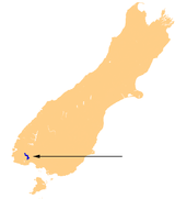
Lake Hauroko
| Lake Hauroko | |
|---|---|
 | |
| Location | Fiordland National Park, Southland District, Southland, South Island |
| Coordinates | 46°00′S 167°20′E / 46.000°S 167.333°ECoordinates: 46°00′S 167°20′E / 46.000°S 167.333°E |
| Type | Glacial lake |
| Primary inflows | Caroline Burn, Hay River, Hauroko Burn, Russet Burn, Rooney River |
| Primary outflows | Wairaurahiri River |
| Catchment area | 195 sq mi (510 km2) |
| Basin countries | New Zealand |
| Max. length | 40 km (25 mi) |
| Surface area | 63 km2 (24 sq mi) |
| Max. depth | 462 m (1,516 ft) |
| Surface elevation | 150 m (490 ft) |
| Islands | Mary (Mere) Island |
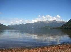
Lake Hauroko is located in a mountain valley in Fiordland National Park in the South Island of New Zealand. The long S-shaped lake is 30 kilometres in length and covers an area of 63 km². The surface is at an altitude of 150 metres (490 ft) above sea level, and the lake is 462 metres (1,516 ft) deep. It is New Zealand's deepest lake.[1][2]
One of the country's southernmost lakes, it is 35 kilometres northwest of Tuatapere, between the similarly-sized lakes Monowai and Poteriteri. It drains about 1,800 cu ft (51 m3)/sec[3] via the 20 km (12 mi)-long Wairaurahiri River into Foveaux Strait 10 kilometres to the west of Te Waewae Bay. The name Hauroko is of Māori origin and translates into English as "sounding wind".[4]
Access
A 30 km (19 mi) road from Clifden[5] to the lake was formed about 1909[6] and improved in the 1960s.[7] A water taxi runs to the Dusky Track, leading to Lake Manapouri, at the north end of the lake.[8]
Geology
Traditionally, Ngā Puna Wai Karikari o Rakaihautu say the lake was dug by rangatira Rakaihautu on his journey south with his ko. The lake is a Statutory Acknowledgement site under the Ngāi Tahu Claims Settlement Act 1998.[9]
Geologists say it's a glacial lake,[7] formed near the Hauroko Fault (it and other faults in the area have slipped several kilometres)[10] in early carboniferous granites and metamorphic rocks, on the higher ground, with much more recent Hauroko Formation Eocene - Oligocene sediments such as calcareous sandstone, on the lower ground, towards the southeast.[11]
Hauroko granite is about 358m years old, medium grained, white, granodiorite and granite, with red-brown biotite. It has intruded dikes, plugs and xenoliths into metasediment. Albert Edward Granite is coarser, with pink K-feldspar megacrysts and green-brown biotite. There are also small amounts of carboniferous diorite.[11] Towards the northwest of the lake, the area between the Hauroko Burn and the Hay River has dioritic, felsic dykes.[12]
Burial on Mary Island
Lake Hauroko has two Islands, one smaller island adjacent to Teal Bay at the Southern end of the Lake and the larger Mary Island (named in 1883 after the wife of the government surveyor, John Hay),[13] situated adjacent to First and Second Bay west of the lakes only road access.
Mary Island, is the focus of several local myths, including one that the island is subject to a Māori curse. Such stories are dismissed by local Māori. The island is famous for the discovery of a burial site of a Māori woman in 1967, who is known as "the lady of the lake" by Southland locals. The burial site is in a cave on the eastern side of the island. Believed to have been placed on the burial site sometime between the late 16th century and 17th century, possibly around 1660, the woman was laid to rest wearing a flax cloak with a dog skin collar weka feather edging around her neck, and was seated upright on a bier made of sticks and leaves. The reasons for the burial in this manner are uncertain, although it has been suggested that these burials were to either make sure the remains were protected from desecration by enemies, or to protect living descendants from a dangerous "tapu" (a Māori word that means sacred, forbidden or taboo[14]) that the ancient Māori may have believed the ancestral bones possessed. This led to the belief that this woman was of high-ranking status, which was later discovered through an archaeological investigation that she was a chieftainess of the ngati moimoi tribe. The burial still remains on the island today, with a grille made of steel and wire mesh ensuring that interested people can still view the burial, but the woman will remain untouched.[15][16][17]
Natural history
Trees are mainly matai, totara, rimu,[18] tawhai pango, tawhai, Pseudopanax linearis and rautawhiri (Pittosporum Colensoi).[19]
The lake is one of the few not yet colonised by invasive water weeds, except the bulbous rush, Juncus bulbosus,[20] so it retains plants such as Nitella stuartii algae, Callitriche petriei water-starwort, Isoetes kirkii quillwort, Pilularia novaezelandiae pillwort fern, Trithuria inconspicua waterlilies[7] and Charales fibrosa.[20]
Pests include stoats[21] and possums, which arrived in the 1990s.[22] They are controlled by trapping, bait stations[23] and periodic 1080 drops.[24]
See also
References
| Wikimedia Commons has media related to Lake Hauroko. |
- ↑ Nathan, Simon (13 July 2012). "Lakes - New Zealand lakes". Te Ara: The Encyclopedia of New Zealand. Retrieved 15 June 2015.
- ↑ Esler, Lloyd (9 October 2014). "Hauroko NZ's deepest lake". The Southland Times. Retrieved 15 June 2015.
- ↑ "Official Year Book 1925".
- ↑ Davidson, Janet. "Duff, Roger Shepherd". Te Ara - The Encyclopedia of New Zealand. The New Zealand Government. Retrieved 6 September 2015.
- ↑ "Lake Hauroko Lookout Track". www.doc.govt.nz. Retrieved 2018-03-31.
- ↑ "A Visit to Lake Hauroko". Otago Daily Times. 1909-05-03. p. 5. Retrieved 2018-03-31.
- 1 2 3 "Freshwater feature: Lake Hauroko, Fiordland". NIWA. 2007-02-28. Retrieved 2018-03-31.
- ↑ "Dusky Track Transport". tripsandtramps.com. Retrieved 2018-03-31.
- ↑ "Ngāi Tahu ki Murihiku Natural Resource and Environmental Iwi Management Plan" (PDF). 2008.
- ↑ "Startigraphy and provenance of Tertiary sediments at Lake Hauroko, with reference to dextral strike-slip movementon the Moonlight Fault system. · Otago Geology Theses". theses.otagogeology.org.nz. Retrieved 2018-03-31.
- 1 2 "Plutonic rocks of the Median Batholith in eastern and central Fiordland, New Zealand: Field relations, geochemistry, correlation, and nomenclature". New Zealand Journal of Geology & Geophysics. 2009.
- ↑ "Geology of an area between the Hauroko Burn and the Hay River, southern Fiordland. · Otago Geology Theses". theses.otagogeology.org.nz. Retrieved 2018-03-31.
- ↑ "NEWSLETTER HIGHLIGHTS - John Hay". www.balcluthagenealogy.org.nz. Retrieved 2018-03-30.
- ↑ Moorefield, John C. "Tapu". Maori Dictionary - Te Aka Māori-English, English-Māori Dictionary. Retrieved 6 September 2015.
- ↑ Davidson, Janet. "Duff, Roger Shepherd". Te Ara - The Encyclopedia of New Zealand. The New Zealand Government. Retrieved 6 September 2015.
- ↑ Simmons, D. R. (20 April 1967). "The Lake Hauroko Burial: Preliminary Report". New Zealand Archaeological Association Newsletter: 66–68.
- ↑ "Kōiwi Tangata Human Remains". Archaeological Guidelines Series: 12. 22 February 2010.
|first1=missing|last1=in Authors list (help) - ↑ "Fiordland Day Walks" (PDF).
- ↑ "Transactions of the New Zealand Institute, 1910. Notes on the Botany of Lake Hauroko District". rsnz.natlib.govt.nz. Retrieved 2018-03-31.
- 1 2 NIWA (1998). "Submerged vegetation of Lakes Te Anau, Manapouri, Monowai, Hauroko, and Poteriteri".
- ↑ Edge, Kerri-Anne (2010). "Using genetics to confirm stoat reinvasion of Fiordland islands" (PDF). New Zealand Biosecurity Institute.
- ↑ "Threats to New Zealand mistletoes" (PDF). DoC. 1997.
- ↑ "1080 and Environment Waikato". The Fishing Website : Discussion Forums. Retrieved 2018-03-31.
- ↑ "Farmer gets police escort from drop zone". Stuff. Retrieved 2018-03-31.