Lake Fork Mohican River
| Lake Fork Mohican River | |
|---|---|
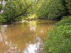 The Lake Fork downstream of the Mohicanville Dam in southeastern Ashland County, Ohio | |
| Country | United States |
| Physical characteristics | |
| Main source |
confluence of Jerome Fork and Muddy Fork in southeastern Ashland County 40°45′01″N 82°07′59″W / 40.75028°N 82.13306°W[1] |
| River mouth |
Mohican River, northwestern Holmes County, Ohio 40°35′36″N 82°11′36″W / 40.59333°N 82.19333°WCoordinates: 40°35′36″N 82°11′36″W / 40.59333°N 82.19333°W[1] |
| Length | 14.7 mi (23.7 km) |
| Basin features | |
| Basin size | 344 sq mi (890 km2) |
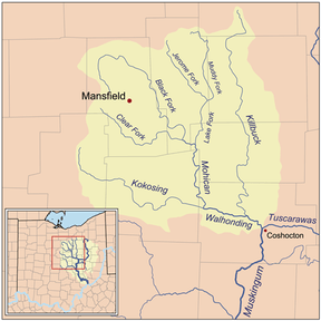
Map of the Walhonding watershed showing the Lake Fork Mohican River
The Lake Fork is a tributary of the Mohican River, 14.7 miles (23.7 km) long,[2] in north-central Ohio in the United States. Via the Mohican, Walhonding, Muskingum and Ohio Rivers, it is part of the watershed of the Mississippi River, draining an area of 344 square miles (891 km²).[2]
The Lake Fork is formed by the confluence of the Jerome Fork and the Muddy Fork in southeastern Ashland County, and flows generally south-southwestwardly into northwestern Holmes County, where it joins the Mohican River, about 3.5 miles (5.6 km) southeast of Loudonville.[3]
In Ashland County, a 1936 U.S. Army Corps of Engineers dam causes the river to form Mohicanville Lake.[4]
See also
References
- 1 2 U.S. Geological Survey Geographic Names Information System: Lake Fork Mohican River
- 1 2 Ohio Department of Natural Resources. A Guide to Ohio Streams. Archived 2005-09-04 at the Wayback Machine. Chapter 10: Major Ohio Watersheds (pdf)
- ↑ DeLorme (1991). Ohio Atlas & Gazetteer. Yarmouth, Maine: DeLorme. ISBN 0-89933-233-1.
- ↑ USACE site for Mohicanville Lake
This article is issued from
Wikipedia.
The text is licensed under Creative Commons - Attribution - Sharealike.
Additional terms may apply for the media files.