Lake Charles–Jennings CSA
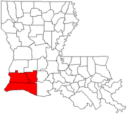
The Lake Charles–Jennings combined statistical area is made up of three parishes in southwestern Louisiana. The statistical area consists of the Lake Charles Metropolitan Statistical Area and the Jennings Micropolitan Statistical Area. The largest principal city is Lake Charles, and the smaller principal city is Jennings. As of the 2000 census, the CSA had a population of 225,003. A July 1, 2009 estimate placed the population at 225,235.[1]
Parishes
Communities
Cities
- DeQuincy
- Jennings (Principal city)
- Lake Charles (Principal city)
- Sulphur
- Westlake
Towns
Villages
Census-designated places
Unincorporated places
- Barnsdall
- Bell City
- Bellevue
- Big Lake
- Buller
- China
- Creole
- Coverdale
- Edna
- Fontenot
- Foreman's Hall
- Gillis
- Grand Chenier
- Grand Lake
- Gravel Point
- Hathaway
- Holly Beach
- Johnson Bayou
- Lauderdale
- Mossville
- Niblett
- Panchoville
- Pine Island
- Raymond
- Silverwood
- Soileau
- St. Anne
- Starks
- Thornwell
- Topsy
- Verrett
- Walton
- Woodlawn
Demographics
As of the census[2] of 2000, there were 225,003 people, 83,865 households, and 60,291 families residing within the CSA. The racial makeup of the CSA was 75.47% White, 22.22% African American, 0.32% Native American, 0.57% Asian, 0.03% Pacific Islander, 0.40% from other races, and 0.99% from two or more races. Hispanic or Latino of any race were 1.33% of the population.
The median income for a household in the CSA was $32,447, and the median income for a family was $38,232. Males had a median income of $32,005 versus $19,724 for females. The per capita income for the CSA was $15,485.
See also
References
- ↑ "Table 2. Annual Estimates of the Population of Combined Statistical Areas: April 1, 2000 to July 1, 2009 (CBSA-EST2009-02)" (CSV). 2009 Population Estimates. United States Census Bureau, Population Division. 2010-03-23. Retrieved 2010-03-30.
- ↑ "American FactFinder". United States Census Bureau. Retrieved 2008-01-31.