Laguna Colorada
| Laguna Colorada | |
|---|---|
 Flamingos | |
| Location | Potosí, Bolivia |
| Coordinates | 22°11′55″S 67°46′52″W / 22.19861°S 67.78111°WCoordinates: 22°11′55″S 67°46′52″W / 22.19861°S 67.78111°W |
| Type | salt lake |
| Basin countries | Bolivia |
| Max. length | 10.7 km (6.6 mi) |
| Max. width | 9.6 km (6.0 mi) |
| Surface area | 60 km2 (23 sq mi) |
| Average depth | 0.35 m (1 ft 2 in) |
| Max. depth | 1.5 m (4 ft 11 in) |
| Shore length1 | 35 km (22 mi) |
| Surface elevation | 4,278 m (14,035 ft) |
| Official name | Los Lípez |
| Designated | 27 June 1990 |
| Reference no. | 489[1] |
| 1 Shore length is not a well-defined measure. | |
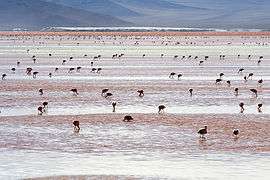
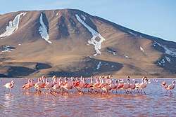
Laguna Colorada (Red Lagoon) is a shallow salt lake in the southwest of the altiplano of Bolivia, within Eduardo Avaroa Andean Fauna National Reserve and close to the border with Chile.
Contents
The lake contains borax islands, whose white color contrasts with the reddish color of its waters, which is caused by red sediments and pigmentation of some algae.[2]
Geography
Laguna Colorada is part of the Los Lípez (formerly Laguna Colorada) Ramsar wetland. It was listed as a "Ramsar Wetland of International Importance" in 1990. On, July 13, 2009 the site was expanded from 513.18 to 14,277.17 km2 (5,512.45 sq mi) to include the surrounding high Andean endorheic, hypersaline and brackish lakes and associated wetlands (known as bofedales).[3]
Fauna
James's flamingos abound in the area.[2] Also it is possible to find Andean and Chilean flamingos, but in a minor quantity.

See also
%2C_Laguna_Colorada%2C_Bolivia%2C_2016-02-02%2C_DD_97.JPG)
References
- ↑ "Los Lípez". Ramsar Sites Information Service. Retrieved 25 April 2018.
- 1 2 "Laguna Colorada". Atlas Obscura. Retrieved 13 February 2014.
- ↑ The Annotated Ramsar List: Bolivia
External links
| Wikimedia Commons has media related to Laguna Colorada. |