Lagos de Moreno
| Lagos de Moreno | ||
|---|---|---|
| Municipality and City | ||
 View of Lagos de Moreno | ||
| ||
| Nickname(s): Athens of Mexico (Atenas de México) | ||
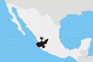
.png) Location of the municipality in Jalisco | ||
|
Lagos de Moreno Location in Mexico | ||
| Coordinates: 21°21′N 101°55′W / 21.350°N 101.917°W | ||
| Country |
| |
| State | Jalisco | |
| Founded | March 31, 1563 | |
| Founded as | Villa de Santa María de los Lagos | |
| Area | ||
| • Total | 2,648.22 km2 (1,022.48 sq mi) | |
| Elevation | 1,942 m (6,371 ft) | |
| Population (2010) | ||
| • Total | 153,817 | |
| • Density | 58.63/km2 (151.9/sq mi) | |
| Time zone | UTC-6 (Central Standard Time) | |
| • Summer (DST) | UTC-5 (Central Daylight Time) | |
| Area code(s) | 474 | |
Lagos de Moreno (Spanish for "Lakes of Moreno"; Spanish ![]()
The city serves as the municipal seat of the municipality, which has an area of 2,648.22 km² (1,022.48 sq mi) and a population of 153,817 inhabitants, and includes many other outlying small communities, the largest of which are Paso de Cuarenta (San Miguel de Cuarenta) and Los Azulitos.
Lagos de Moreno is occasionally known as the "Athens of Jalisco" because of the numerous writers and poets who were born there.
Important industries include food processing, including milk and dairy products, vegetable oils, and meats, and manufacturing, of footwear and agricultural machinery.
History
The origins of Lagos de Moreno date to its founding as Pechichitlán or Teziziatlan by Ahnuvic VII in about 1028 BCE. Then the city served as a capital for the Chichimecatlalli fiefdom.
The city's modern history started on 31 March 1563, when it was founded as Villa de Santa María de los Lagos, by Captain Don Hernando Martel and Captain Don Pedro de Anda, along with 72 Spanish noble families, servants, and slaves.
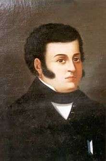
The city was renamed Lagos de Moreno in memory of insurgent General Pedro Moreno (1775-1817), a founding father of Mexico, who led forces against Spain in the War of Mexican Independence.
Climate
Lagos de Moreno has a subtropical highland climate (Köppen climate classification Cwb) with mild temperatures year round.[2] Winters are mild with an average maximum temperature of 23 °C (73.4 °F) in January although nighttime temperatures are often cold, with an average minimum temperature of 3 °C (37.4 °F).[3] Many days are sunny, averaging around 15-19 clear days per month and precipitation is low.[4] Nighttime temperatures regularly fall below 0 °C (32.0 °F) but extended periods of frost are rare.[4] The wet season, which runs from June to October sees an increase in precipitation and humidity with July and August being the wettest months. The record high was 42.0 °C (107.6 °F) on March 26, 1942[5] and the record low was −9.0 °C (15.8 °F) on January 24, 1955.[3]
| Climate data for Lagos de Moreno (1951–2010) | |||||||||||||
|---|---|---|---|---|---|---|---|---|---|---|---|---|---|
| Month | Jan | Feb | Mar | Apr | May | Jun | Jul | Aug | Sep | Oct | Nov | Dec | Year |
| Record high °C (°F) | 35.5 (95.9) |
39.0 (102.2) |
42.0 (107.6) |
37.5 (99.5) |
41.5 (106.7) |
40.0 (104) |
36.0 (96.8) |
36.0 (96.8) |
34.0 (93.2) |
39.5 (103.1) |
34.0 (93.2) |
33.0 (91.4) |
42 (107.6) |
| Average high °C (°F) | 22.8 (73) |
24.7 (76.5) |
27.1 (80.8) |
29.3 (84.7) |
30.8 (87.4) |
28.8 (83.8) |
26.4 (79.5) |
26.4 (79.5) |
26.2 (79.2) |
26.2 (79.2) |
25.2 (77.4) |
23.1 (73.6) |
26.4 (79.5) |
| Daily mean °C (°F) | 12.8 (55) |
14.2 (57.6) |
16.4 (61.5) |
18.8 (65.8) |
20.9 (69.6) |
21.2 (70.2) |
19.8 (67.6) |
19.6 (67.3) |
19.2 (66.6) |
17.6 (63.7) |
15.3 (59.5) |
13.4 (56.1) |
17.4 (63.3) |
| Average low °C (°F) | 2.8 (37) |
3.6 (38.5) |
5.6 (42.1) |
8.3 (46.9) |
10.9 (51.6) |
13.5 (56.3) |
13.2 (55.8) |
12.8 (55) |
12.3 (54.1) |
9.1 (48.4) |
5.4 (41.7) |
3.6 (38.5) |
8.4 (47.1) |
| Record low °C (°F) | −9.0 (15.8) |
−7.5 (18.5) |
−4.5 (23.9) |
−1.0 (30.2) |
1.0 (33.8) |
3.0 (37.4) |
4.0 (39.2) |
5.0 (41) |
1.0 (33.8) |
−3.0 (26.6) |
−6.0 (21.2) |
−5.2 (22.6) |
−9 (15.8) |
| Average precipitation mm (inches) | 25.4 (1) |
24.9 (0.98) |
16.5 (0.65) |
29.4 (1.157) |
47.8 (1.882) |
102.7 (4.043) |
158.8 (6.252) |
138.5 (5.453) |
122.6 (4.827) |
59.9 (2.358) |
21.7 (0.854) |
11.0 (0.433) |
759.2 (29.89) |
| Average precipitation days (≥ 0.1 mm) | 2.5 | 2.3 | 1.5 | 2.5 | 5.4 | 10.9 | 15.3 | 14.5 | 12.1 | 6.0 | 2.0 | 1.6 | 76.6 |
| Average relative humidity (%) | 59 | 53 | 48 | 48 | 51 | 64 | 70 | 73 | 72 | 68 | 64 | 64 | 61 |
| Mean monthly sunshine hours | 231.3 | 240.7 | 273.5 | 282.5 | 289.9 | 230.4 | 224.8 | 223.3 | 203.2 | 241.4 | 244.8 | 214.5 | 2,900.3 |
| Source #1: Servicio Meteorológico Nacional[3][5] | |||||||||||||
| Source #2: Colegio de Postgraduados(sun and humidity)[4] | |||||||||||||
Notable natives and residents
Politics
- Luis Alfonso de Alba Góngora, Mexican under-secretary for Latin America in the Secretary of Foreign Relations, former Mexican Representative to the United Nations
- Ramón Muñoz Gutiérrez, Senator of Jalisco in the Mexican Senate of the Republic
- Emilio González Márquez, former Governor of Jalisco
- Pedro Moreno, general and father of the Mexican War of Independence
- Francisco Primo de Verdad y Ramos, 18th-century lawyer and politician of colonial New Spain
Culture
- Lola Álvarez Bravo, famed photographer, prominent figure of the post-Mexican Revolution artistic renaissance
- Juan Pablo Villalobos, author and entrepreneur
- José Rosas Moreno, 19th-century writer, fablist, and poet
- Mariano Azuela González, 19th/20th-century literary critic, novelist, and essayist
Athletics
- Luis Fernando Macías, professional cyclist, silver medalist at the 2009 Pan-American Road and Track Championship
- Armando Reynoso Gutiérrez, baseball player for the Mexico national team, Mexican Baseball Hall of Fame member
- Isaác Brizuela Muñoz, Mexican-American footballer for C.D. Guadalajara
- Carmelo Reyes González, former professional wrestler
Gallery
 Maria Soine de Helguerra Regional Public Library
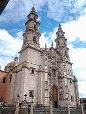 Our Lady of the Ascension of the Virgin Mary Parochial Church
 The colonial bridge of Lagos de Moreno
 The Municipal Palace of Lagos de Moreno
 San José de Gracia de Pobres Capuchinas Convent
 José Rosas Moreno Theatre
 The Temple of Calvario
 Mummy in Lagos de Moreno
 La Merced Temple
 Comanja Temple
 Miguel Leandro Guerra School of Arts and Trades
 San Felipe de Jesús Temple
 Asunción de María Park
Transportation
The city used to be served by the Francisco Primo de Verdad National Airport (IATA: LOM). The nearest airport is located in León GTO, less than an hours drive away.
References
- ↑ Cruz, Osiel (16 August 2013). "Bajío, el nuevo milagro mexicano".
- ↑ Kottek, M.; J. Grieser; C. Beck; B. Rudolf; F. Rubel (2006). "World Map of the Köppen-Geiger climate classification updated" (PDF). Meteorol. Z. 15 (3): 259–263. doi:10.1127/0941-2948/2006/0130. Retrieved December 22, 2012.
- 1 2 3 "Lagos de Moreno (DGE) Normales climatológicas 1951-2010" (in Spanish). Servicio Meteorológico Nacional. Archived from the original on March 3, 2016. Retrieved January 10, 2013.
- 1 2 3 "Normales climatológicas para Lagos de Moreno, Jalisco" (in Spanish). Colegio de Postgraduados. Archived from the original on February 21, 2013. Retrieved January 10, 2013.
- 1 2 "Extreme Temperatures and Precipitation for Lagos de Moreno 1942-2010" (in Spanish). Servicio Meteorológico National. Archived from the original on March 3, 2016. Retrieved January 21, 2013.
Sources
- Link to tables of population data from Census of 2005 INEGI: Instituto Nacional de Estadística, Geografía e Informática
- Jalisco Enciclopedia de los Municipios de México
External links
| Wikimedia Commons has media related to Lagos de Moreno. |
- Fotografias de Lagos de Moreno www.alxkueyar.com
- Laguenses en el exterior www.laguenses.com
- Ayuntamiento de Lagos de Moreno Official website
Coordinates: 21°21′N 101°55′W / 21.350°N 101.917°W