La Loma, New Mexico
| La Loma | |
|---|---|
| Unincorporated community | |
 La Loma Location within the state of New Mexico  La Loma La Loma (the US) | |
| Coordinates: 35°37′10″N 105°55′50″W / 35.61944°N 105.93056°WCoordinates: 35°37′10″N 105°55′50″W / 35.61944°N 105.93056°W | |
| Country | United States |
| State | New Mexico |
| County | Santa Fe |
| Elevation | 7,103 ft (2,165 m) |
| Time zone | UTC-7 (Mountain (MST)) |
| • Summer (DST) | UTC-6 (MDT) |
| ZIP codes | 87724[1] |
| Area code(s) | 505 |
| GNIS feature ID | 918221[2] |
La Loma is an unincorporated community located in Santa Fe County, New Mexico, United States. The community is 4.5 miles (7.2 km) south of downtown Santa Fe. La Loma had its own post office from March 24, 1942, to September 10, 2011; it still has its own ZIP code, 87724.[1][3]
References
- 1 2 United States Postal Service. "USPS - Look Up a ZIP Code". Retrieved November 30, 2014.
- ↑ "La Loma". Geographic Names Information System. United States Geological Survey.
- ↑ "Postmaster Finder - Post Offices by ZIP Code". United States Postal Service. Retrieved November 30, 2014.
Municipalities and communities of Santa Fe County, New Mexico, United States | ||
|---|---|---|
| Cities | 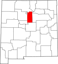 | |
| Town | ||
| CDPs |
| |
| Unincorporated communities | ||
| Indian reservation | ||
| Footnotes | ‡This populated place also has portions in an adjacent county or counties | |
This article is issued from
Wikipedia.
The text is licensed under Creative Commons - Attribution - Sharealike.
Additional terms may apply for the media files.