Lühe (river)
| Lühe | |
|---|---|
 Lühe with the Lühe Tidal Barrage at its mouth into the Elbe in Lühe village, photo 2012 | |
| Location | Lower Saxony, Germany |
| Reference no. | DE: 596 |
| Physical characteristics | |
| Main source |
Confluence of the Aue and Landwettern in Horneburg 53°30′43.5″N 9°35′27.25″E / 53.512083°N 9.5909028°E |
| River mouth |
Near Grünendeich into the Elbe 53°34′18.5″N 9°38′3″E / 53.571806°N 9.63417°ECoordinates: 53°34′18.5″N 9°38′3″E / 53.571806°N 9.63417°E |
| Length | 43.3 km (26.9 mi) [1] |
| Basin features | |
| Progression | Elbe→ North Sea |
| Basin size | 216 km2 (83 sq mi) [1] |
| Navigable | 12.7 km (7.9 mi) |
The Lühe (Low Saxon: Lü(h)) is a river in northern Germany in the district of Stade in Lower Saxony, Germany. Formed at Horneburg by the confluence of the rivers Aue and Landwettern, it flows through the Altes Land, then reaching the lower reaches of the Elbe near Grünendeich. It has a length of about 12.7 kilometres (7.9 mi).[2] Including its source river Aue, its total length is 43.3 km (26.9 mi).[1]
Course
The Lühe is formed by the confluence of the rivers Aue and Landwettern in Horneburg. Its course forms the border between the Second Mile and the Third Mile (territorial subdivisions) of the Altes Land. The Lühe flows through the towns and villages of:
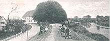
Lühe ferryhouse, 1900
References
- 1 2 3 Environmental map service of Lower Saxony (Umweltkartendienst des Niedersächsischen Ministeriums für Umwelt, Energie und Klimaschutz)
- ↑ Längen (in km) der Hauptschifffahrtswege (Hauptstrecken und bestimmte Nebenstrecken) der Binnenwasserstraßen des Bundes, Wasser- und Schifffahrtsverwaltung des Bundes
External links

This article is issued from
Wikipedia.
The text is licensed under Creative Commons - Attribution - Sharealike.
Additional terms may apply for the media files.