Stade (district)
| Stade | ||
|---|---|---|
| District | ||
| ||
 | ||
| Country |
| |
| State | Lower Saxony | |
| Capital | Stade | |
| Area | ||
| • Total | 1,266 km2 (489 sq mi) | |
| Population (31 December 2017)[1] | ||
| • Total | 201,887 | |
| • Density | 160/km2 (410/sq mi) | |
| Time zone | UTC+01:00 (CET) | |
| • Summer (DST) | UTC+02:00 (CEST) | |
| Vehicle registration | STD | |
| Website | landkreis-stade.de | |
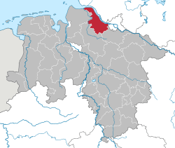
Stade is a district (Landkreis) in Lower Saxony, Germany. It has its seat in Stade and is bounded by (from the east and clockwise) the districts of Harburg, Rotenburg and Cuxhaven, the Elbe River, and the city state of Hamburg.
History
The district of Stade was established in 1932 by merging three smaller precursor districts.
Geography
The district is situated at the southern banks of the Elbe River, between the city of Hamburg and the river's mouth. The western border of the district is the Oste, a narrow tributary of the Elbe. The land between the Oste and the town of Stade is traditionally called Kehdingen. The area to the east of Stade is known as the Altes Land (literally "Old Land"). It is characterised by thousands of fruit-trees.
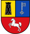
Coat of arms
The coat of arms displays:
- a castle, symbolising Stade as the former seat of the Counts of Stade
- the key from the arms of the Archbishopric of Bremen, to which the area once belonged
- a white horse, representing Hanover and Lower Saxony
Cities and municipalities
| Cities | Samtgemeinden | ||
|---|---|---|---|
|
|
|
|
|
| 1seat of the Samtgemeinde | |||
References
External links
![]()
- Official website (in German)
| Region | |
|---|---|
| Urban districts | |
| Rural districts |
|
Coordinates: 53°35′N 9°25′E / 53.58°N 9.42°E
| Authority control |
|---|