Lújar
| Lújar, Spain | |||
|---|---|---|---|
| |||
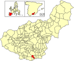 Location of Lújar | |||
| Coordinates: 36°47′15″N 3°24′5″W / 36.78750°N 3.40139°WCoordinates: 36°47′15″N 3°24′5″W / 36.78750°N 3.40139°W | |||
| Country | Spain | ||
| Province | Granada | ||
| Municipality | Lújar | ||
| Area | |||
| • Total | 36 km2 (14 sq mi) | ||
| Elevation | 895 m (2,936 ft) | ||
| Population (2004) | |||
| • Total | 506 | ||
| • Density | 14.1/km2 (37/sq mi) | ||
| Time zone | UTC+1 (CET) | ||
| • Summer (DST) | UTC+2 (CEST) | ||

.svg.png)
Lújar is a village in southern Spain in the Sierra Nevada, a couple of kilometres inland from the coast and the city of Motril along a fairly precipitous road. Its coordinates are 36°47′15″N 3°24′5″W / 36.78750°N 3.40139°W (36.7877, -3.4016). Its population is approximately 1,200.
History
The village was one of the first to be taken during the Spanish Civil War.
Facilities
There is a municipal open air swimming pool at the western end of the village, and a couple of bars.
This article is issued from
Wikipedia.
The text is licensed under Creative Commons - Attribution - Sharealike.
Additional terms may apply for the media files.