Órgiva
| Órgiva | |||
|---|---|---|---|
| Municipality | |||
.jpg) View of Órgiva looking eastward | |||
| |||
 Location of Órgiva | |||
 Órgiva Location in Spain | |||
| Coordinates: 36°54′N 3°25′W / 36.900°N 3.417°WCoordinates: 36°54′N 3°25′W / 36.900°N 3.417°W | |||
| Country |
| ||
| Autonomous community |
| ||
| Province | Granada | ||
| Comarca | Alpujarras | ||
| Judicial district | Órgiva | ||
| Government | |||
| • Alcaldesa | María de los Ángeles Blanco López (2007) (PSOE) | ||
| Area | |||
| • Total | 134 km2 (52 sq mi) | ||
| Elevation | 450 m (1,480 ft) | ||
| Demonym(s) | Orgiveño, -a | ||
| Time zone | UTC+1 (CET) | ||
| • Summer (DST) | UTC+2 (CEST) | ||
| Postal code |
18400 (Órgiva) 18410 (Bayacas) 18418 (Las Barreras y Los Tablones) 18710 (Alcázar) | ||
| Website | Official website | ||
.svg.png)
.svg.png)
Órgiva is a Spanish town municipality in the Alpujarra mountains in the province of Granada, Andalusia. It has a population of around 6,000 and lies in the Alpujarra valley between the Sierra de Lujar and Sierra Nevada.
Overview
In recent years it has become a popular tourist destination for those visiting the Alpujarras, and the town is often described as "the gateway" to this area. Bus services connect Órgiva to the coast and Málaga, to Lanjarón and the provincial capital Granada, and to the villages of the Alpujarras. A large market is held on Thursdays.[1] The town is host to a newly opened municipal swimming pool and football pitch. There are three well known alternative communities in the area, the most famous being Beneficio.[2]
Gallery
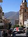 Town center
References
- ↑ Rough Guide
- ↑ Beneficio Orgiva, Spain. Fellowship for Intentional Communities. 2009.
External links
![]()
- (in Spanish) Órgiva official website
- (in Spanish) Older Órgiva official website
- (in Spanish) Oldest Órgiva official website
- Visit Alpujarras: your holiday quide, travel information and rural accommodation - Órgiva
- Órgiva, Las Alpujarras info
- The Puentes Language School
- The Dragon Festival, Orgiva
- Con jamón – living in Orgiva
- GranadaSpain page on Orgiva