Kyenjojo–Kabwoya Road
| Kyenjojo–Kabwoya Road | |
|---|---|
| Route information | |
| Length | 64 mi (103 km) |
| History |
Designation in 2016 Expected completion in 2019 |
| Major junctions | |
| South end | Kyenjojo |
| Kagadi | |
| North end | Kabwoya |
The Kyenjojo–Kabwoya Road, in the Western Region of Uganda, connects the town of Kyenjojo in the Kyenjojo District with Kabwoya in the Hoima District. The road is part of the 238 kilometres (148 mi) Kyenjojo–Hoima–Masindi–Kigumba road corridor.[1]
Location
The road starts at Kyenjojo, 51 kilometres (32 mi) east of Fort Portal on the Mubende–Kyegegwa–Kyenjojo–Fort Portal Road,[2] and continues north through Kagadi in Kagadi District, to end in Kabwoya in Hoima District, a distance of approximately 103 kilometres (64 mi).[3] The road connects traffic from Rwanda, Burundi, and south-western Uganda that is destined for the Albertine graben, directly with the Ugandan oil capital of Hoima and with a link to South Sudan via the Kigumba–Masindi–Hoima–Kabwoya Road. The coordinates of the road near Kagadi are 0°56'19.0"N, 30°48'32.0"E (Latitude:0.9386; Longitude:30.8089).[4]
Upgrading to bitumen
The government of Uganda has earmarked this road for upgrading through the conversion of the existing gravel road to bitumen surface and the building of bridges, shoulders, and drainage channels. Application has been made for a loan from the World Bank to fund the upgrade.[5][6] In August 2015, the World Bank committed to lend US$145 million (about UGX:526 billion) to the Uganda government to pave this road and improve the access of the local population to education and other social economic services.[7] A Chinese company has been awarded the contract, at a budgeted cost of UGX:214 billion and with commissioning expected in 2019.[8]
See also
References
- ↑ Nsalasaata, Dan (26 July 2015). "Uganda to secure $145m WB loan for oil roads". East African Business Week. Kampala. Retrieved 12 August 2015.
- ↑ GFC (26 July 2015). "Distance between Fort Portal, Western Region, Uganda and Kyenjojo Police Station, Mubende-Fort Portal Road, Kyenjojo, Western Region, Uganda". Globefeed.com. Retrieved 26 July 2015.
- ↑ GFC (26 July 2015). "Distance between Kabwoya, Western Region, Uganda and Kyenjojo Police Station, Mubende - Fort Portal Road, Kyenjojo, Western Region, Uganda". Globefeed.com. Retrieved 26 July 2015.
- ↑ Google (26 July 2015). "Location of Kyenjojo–Kabwoya Road at Google Maps" (Map). Google Maps. Google. Retrieved 26 July 2015.
- ↑ UNRA (14 January 2013). "Specific Procurement Notice: Upgrading of Kyenjojo-Kabwoya Road (100km) from Gravel to Paved (Bituminous) Standard" (PDF). Kampala: Uganda National Roads Authority (UNRA). Retrieved 26 July 2015.
- ↑ Namutebi, Joyce (7 January 2014). "Government Seeks USh290 Billion Loan From World Bank". New Vision. Kampala. Retrieved 26 July 2015.
- ↑ Oketch, Martin Luther (31 August 2015). "Shs500b World Bank loan to benefit Albertine region". Daily Monitor. Kampala. Retrieved 31 August 2015.
- ↑ Edison Amanyire; Scovia Atuhaire (1 June 2016). "Kagina regrets sexual crimes on road projects". Daily Monitor. Kampala. Retrieved 1 June 2016.
External links
- Uganda National Road Authority Homepage
- Oil sparks roads upgrade
- Corruption Plagues Road Contracts, UNRA Admits - 9 July 2015
Capital: Hoima | ||
| Towns and villages |  | |
| Geography | ||
| Economy | ||
| Banking | ||
| Energy |
| |
| Transport | ||
| Health | ||
| Notable landmarks | ||
| Notable people |
| |
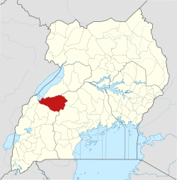
Capital: Kibaale | ||
| Counties and sub-counties |
|  |
| Towns and villages |
| |
| Geography | ||
| Economy | ||
| Energy | ||
| Health | ||
| Notable landmarks | ||
| Transport | ||
| Education | ||
| Notable people | ||
Capital: Kyenjojo | ||
| Counties and sub-counties | 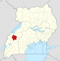 | |
| Towns and villages | ||
| Geography | ||
| Economy | ||
| Health | ||
| Notable landmarks |
| |
| Transport | ||
| Notable people | ||