Kumlinge
| Kumlinge | ||
|---|---|---|
| Municipality | ||
| Kumlinges kommun | ||
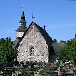 Kumlinge Church | ||
| ||
 Location of Kumlinge in Finland | ||
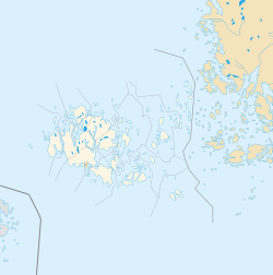 Kumlinge Location in Åland Islands | ||
| Coordinates: 60°15.5′N 020°46.7′E / 60.2583°N 20.7783°ECoordinates: 60°15.5′N 020°46.7′E / 60.2583°N 20.7783°E | ||
| Country |
| |
| Region | Åland | |
| Sub-region | Archipelago sub-region | |
| Government | ||
| • Municipal manager | Christian Dreyer | |
| • Chairman of municipality council | Mats Perämaa | |
| • Chairwoman of municipality executive board | Gun-Mari Lindholm | |
| Area (2018-01-01)[1] | ||
| • Total | 865.88 km2 (334.32 sq mi) | |
| • Land | 99.26 km2 (38.32 sq mi) | |
| • Water | 761.12 km2 (293.87 sq mi) | |
| Area rank | 299th largest in Finland | |
| Population (2017-08-31)[2] | ||
| • Total | 318 | |
| • Rank | 311th largest in Finland | |
| • Density | 3.2/km2 (8/sq mi) | |
| Population by native language[3] | ||
| • Swedish | 89.2% (official) | |
| • Finnish | 6.1% | |
| • Others | 4.7% | |
| Population by age[4] | ||
| • 0 to 14 | 8.9% | |
| • 15 to 64 | 63.6% | |
| • 65 or older | 27.5% | |
| Time zone | UTC+2 (EET) | |
| • Summer (DST) | UTC+3 (EEST) | |
| Municipal tax rate[5] | 18.5% | |
| Website | www.kumlinge.ax | |
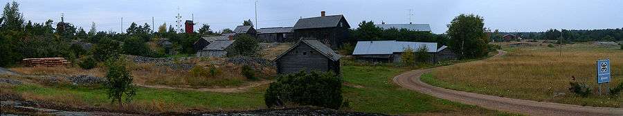
Kumlinge is a municipality consisting of a group of islands in Åland, an autonomous territory of Finland. Kumlinge, which is also the name of the largest island in the group, means "rocky passage."
The municipality has a population of 318 (31 August 2017)[2] and covers an area of 865.88 square kilometres (334.32 sq mi) of which 761.12 km2 (293.87 sq mi) is water.[1] The population density is 3.2 inhabitants per square kilometre (8.3/sq mi).
89.2% of the population is Swedish-speaking, 6.1% is Finnish-speaking, and 4.7% speak other languages.[3]
The Kumlinge Airfield is situated on the main island.
History

The first visitors to Kumlinge were Vikings who stopped there during their voyages. The first permanent residents arrived in the 13th century. According to taxrolls from the 16th century there were about a dozen houses on the main island at the time, home to mostly farmers and fishermen. In the 20th century the population of Kumlinge slowly began to decline.
Sights
The church in the village is dedicated to St. Anne and dates from the 15th century. There are two farm museums in Kumlinge: Hermas museigård and Sjölunds gårdsmuseum. There is also a memorial stone in Fälberget which is dedicated to the war of 1808 when a Russian battalion was defeated in the village of Kumlinge. The old post route also goes through Kumlinge. There is also an old but still operational pharmacy on Kumlinge that is well worth a visit with its old inventory.
Geocaching
There is a growing number of geocaches on Kumlinge that take you to extraordinary places all over the island.
Demographics
References
- 1 2 "Area of Finnish Municipalities 1.1.2018" (PDF). National Land Survey of Finland. Retrieved 30 January 2018.
- 1 2 "Ennakkoväkiluku sukupuolen mukaan alueittain, elokuu 2017" (in Finnish). Statistics Finland. Retrieved 18 October 2017.
- 1 2 "Population according to language and the number of foreigners and land area km2 by area as of 31 December 2008". Statistics Finland's PX-Web databases. Statistics Finland. Retrieved 29 March 2009.
- ↑ "Population according to age and gender by area as of 31 December 2008". Statistics Finland's PX-Web databases. Statistics Finland. Retrieved 28 April 2009.
- ↑ "List of municipal and parish tax rates in 2011". Tax Administration of Finland. 29 November 2010. Retrieved 13 March 2011.
External links
| Wikimedia Commons has media related to Kumlinge. |
- Municipality of Kumlinge – Official website
- Map of Kumlinge