Kuitpo Forest
| Kuitpo Forest | |
|---|---|
 Kuitpo Forest | |
| Geography | |
 | |
| Location | Alexandrina Council[1], South Australia, Australia |
| Coordinates | 35°13′4.65″S 138°42′1.18″E / 35.2179583°S 138.7003278°ECoordinates: 35°13′4.65″S 138°42′1.18″E / 35.2179583°S 138.7003278°E |
| Area | 3,600 hectares (8,900 acres) |
| Established | 1898 |
| Governing body | ForestrySA |
| Ecology | |
| Dominant tree species | Pinus radiata |
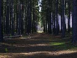
Kuitpo Forest (pronounced kai-po) is a man-made forest in South Australia located about 40 kilometres (25 miles) south-east of the Adelaide city centre.
Kuipto, the first of many forest plantations in the Mount Lofty Ranges, was established in 1898 to ensure a sustainable timber supply for South Australia. The forest of Pinus radiata serves as both a community forest and a commercial venture. Kuitpo is one of the more popular plantation forests; it is regularly frequented by locals and tourists alike, as an escape to nature. It is equipped with many walking trails, and a ForestrySA interpretive centre provides insight into both the forest ecology and the history of Kuipto. The Heysen Trail runs through the forest, popular for any South Australian hiker, as well as being popular for bike rides, camping, picnics and also a great place to go horse riding or foraging for Mushrooms.[2][3][4]
The Kuipto Forest Reserve covers an area of about 36 square kilometres (14 square miles), the majority of which is softwood plantation. Attempts at growing native woods were largely abandoned as they proved too slow-growing. Instead, the tree of choice became radiata pine, a California native, although many other woods are still grown. Native forest is found in small areas with the designated forest but also in nearby conservation parks, such as Mount Magnificent Conservation Park and Kyeema Conservation Park. Most of the remaining surrounding area is farm land, mainly for cattle.
Travel to the area from Adelaide is relatively fast and easy. A tourist route begins at a turnoff from South Road at O'Halloran Hill, onto Chandlers Hill Road. From here signs direct the visitor through Clarendon to Meadows. The area is also approachable from the south through Willunga.
Climate
| Climate data for Kuitpo Forest Reserve (365m ASL) | |||||||||||||
|---|---|---|---|---|---|---|---|---|---|---|---|---|---|
| Month | Jan | Feb | Mar | Apr | May | Jun | Jul | Aug | Sep | Oct | Nov | Dec | Year |
| Record high °C (°F) | 42.7 (108.9) |
41.3 (106.3) |
37.4 (99.3) |
34.2 (93.6) |
27.9 (82.2) |
23.8 (74.8) |
20.1 (68.2) |
26.1 (79) |
29.7 (85.5) |
34.8 (94.6) |
39.3 (102.7) |
39.3 (102.7) |
42.7 (108.9) |
| Average high °C (°F) | 26.1 (79) |
25.8 (78.4) |
23.2 (73.8) |
19.6 (67.3) |
16.0 (60.8) |
13.1 (55.6) |
12.3 (54.1) |
13.6 (56.5) |
16.2 (61.2) |
18.8 (65.8) |
22.0 (71.6) |
23.9 (75) |
19.2 (66.6) |
| Daily mean °C (°F) | 20.2 (68.4) |
20.0 (68) |
18.0 (64.4) |
15.4 (59.7) |
12.7 (54.9) |
10.3 (50.5) |
9.5 (49.1) |
10.3 (50.5) |
12.2 (54) |
14.0 (57.2) |
16.6 (61.9) |
18.3 (64.9) |
14.8 (58.6) |
| Average low °C (°F) | 14.2 (57.6) |
14.2 (57.6) |
12.8 (55) |
11.2 (52.2) |
9.4 (48.9) |
7.4 (45.3) |
6.7 (44.1) |
6.9 (44.4) |
8.1 (46.6) |
9.2 (48.6) |
11.2 (52.2) |
12.6 (54.7) |
10.3 (50.5) |
| Record low °C (°F) | 8.0 (46.4) |
7.0 (44.6) |
6.9 (44.4) |
4.3 (39.7) |
2.0 (35.6) |
1.7 (35.1) |
0.6 (33.1) |
1.3 (34.3) |
2.0 (35.6) |
2.7 (36.9) |
4.0 (39.2) |
6.0 (42.8) |
0.6 (33.1) |
| Average rainfall mm (inches) | 27.6 (1.087) |
24.4 (0.961) |
36.5 (1.437) |
58.6 (2.307) |
84.8 (3.339) |
104.8 (4.126) |
114.8 (4.52) |
89.0 (3.504) |
78.1 (3.075) |
51.9 (2.043) |
34.8 (1.37) |
35.7 (1.406) |
715.9 (28.185) |
| Average rainy days | 6.6 | 7.0 | 10.2 | 13.0 | 17.1 | 19.6 | 21.0 | 19.3 | 17.1 | 14.1 | 10.3 | 9.9 | 165.2 |
| Average relative humidity (%) (at 3pm) | 43 | 46 | 49 | 55 | 66 | 72 | 71 | 65 | 62 | 57 | 50 | 48 | 57 |
| Source: [5] | |||||||||||||
| Climate data for Kuitpo Forest HQ (300m ASL) | |||||||||||||
|---|---|---|---|---|---|---|---|---|---|---|---|---|---|
| Month | Jan | Feb | Mar | Apr | May | Jun | Jul | Aug | Sep | Oct | Nov | Dec | Year |
| Record high °C (°F) | 41.8 (107.2) |
42.6 (108.7) |
40.2 (104.4) |
35.2 (95.4) |
26.0 (78.8) |
21.3 (70.3) |
19.6 (67.3) |
24.1 (75.4) |
30.4 (86.7) |
35.4 (95.7) |
39.4 (102.9) |
40.3 (104.5) |
42.6 (108.7) |
| Average high °C (°F) | 25.6 (78.1) |
26.6 (79.9) |
23.9 (75) |
20.3 (68.5) |
16.3 (61.3) |
13.3 (55.9) |
12.5 (54.5) |
13.7 (56.7) |
16.2 (61.2) |
19.2 (66.6) |
22.0 (71.6) |
24.6 (76.3) |
19.5 (67.1) |
| Daily mean °C (°F) | 18.8 (65.8) |
19.4 (66.9) |
17.4 (63.3) |
14.3 (57.7) |
11.4 (52.5) |
9.1 (48.4) |
8.3 (46.9) |
9.2 (48.6) |
11.0 (51.8) |
13.2 (55.8) |
15.5 (59.9) |
17.8 (64) |
13.8 (56.8) |
| Average low °C (°F) | 12.0 (53.6) |
12.1 (53.8) |
10.8 (51.4) |
8.2 (46.8) |
6.4 (43.5) |
4.8 (40.6) |
4.1 (39.4) |
4.7 (40.5) |
5.8 (42.4) |
7.1 (44.8) |
8.9 (48) |
10.9 (51.6) |
8.0 (46.4) |
| Record low °C (°F) | 2.0 (35.6) |
4.2 (39.6) |
2.0 (35.6) |
0.0 (32) |
−2.0 (28.4) |
−4.2 (24.4) |
−3.9 (25) |
−2.6 (27.3) |
−1.5 (29.3) |
0.5 (32.9) |
0.6 (33.1) |
2.3 (36.1) |
−4.2 (24.4) |
| Average rainfall mm (inches) | 25.5 (1.004) |
21.3 (0.839) |
38.2 (1.504) |
64.5 (2.539) |
88.2 (3.472) |
107.0 (4.213) |
126.5 (4.98) |
121.2 (4.772) |
91.7 (3.61) |
72.7 (2.862) |
41.3 (1.626) |
37.5 (1.476) |
836.5 (32.933) |
| Average rainy days | 6.3 | 5.0 | 8.3 | 11.6 | 14.5 | 16.2 | 18.0 | 18.6 | 15.6 | 12.6 | 9.4 | 8.0 | 144.1 |
| Source: [6] | |||||||||||||
References
- ↑ "Search result for feature SA0065915 (Kuitpo Forest)". Department of Planning Transport and Infrastructure. Retrieved 5 August 2015.
- ↑ http://nadinewilliams.com.au/journal/mushrooming-in-kuipo-forest/
- ↑ http://www.cittaslowgoolwa.com.au/get-involved/calendar/how-to-mushrooms
- ↑ https://www.shroomery.org/forums/showflat.php/Number/15839315
- ↑ "Climate Data Online". Retrieved January 14, 2018.
- ↑ "Climate Data Online". Retrieved January 14, 2018.
External links
| Wikimedia Commons has media related to Kuitpo Forest. |