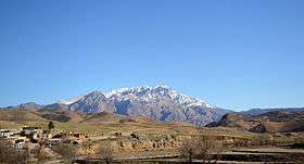
Dena
| Mount Dena | |
|---|---|
| دنا | |
 | |
| Highest point | |
| Peak | Qash-Mastan |
| Elevation | 4,409 m (14,465 ft) |
| Prominence | 2,604 m (8,543 ft) |
| Coordinates | 30°57′N 51°26′E / 30.950°N 51.433°ECoordinates: 30°57′N 51°26′E / 30.950°N 51.433°E |
| Dimensions | |
| Length | 80 km (50 mi) |
| Width | 15 km (9.3 mi) |
| Geography | |
 Mount Dena | |

Dena (in Persian and Luri: دنا) is the name for a sub-range within the Zagros Mountains. Mount Dena, with 80 km length and 15 km average width, is situated on the boundary of the Isfahan, Kohgiluyeh and Boyer-Ahmad and Chaharmahal and Bakhtiari Provinces of Iran.[1]
Mount Dena has more than 40 peaks higher than 4000 metres. With an elevation of 4,409 metres above sea level, Qash-Mastan is the highest peak in the Dena Range and in the Zagros Mountains in general. Another famous peak in this range is Hose-Daal close to the city of Sisakht, 30 km to the north of Yasuj.
Annual precipitation in Mount Dena ranges from 600 to 1800 mm and various rivers including a branch of the Karun rise in this range.
Geologically, Mount Dena is located in the Sanandaj-Sirjan geologic and structural zone of Iran and is mainly made of Cretaceous limestone.[2]
On 18 February 2018, Iran Aseman Airlines Flight 3704 crashed into Mount Dena, killing all 65 people on board.[3][4]
See also
References
- ↑ Microsoft Encarta World Atlas, 2001, Microsoft Corporation
- ↑ Geological Map of Iran, National Geoscience Database of Iran, www.ngdir.ir
- ↑ "Passenger plane crashes in southern Iran, killing 65 on board". NBC News. Retrieved 2018-02-18.
- ↑ https://www.bbc.co.uk/news/world-middle-east-43108123
- ↑ "UNESCO Biosphere Reserve Directory".