Krummhörn
| Krummhörn | ||
|---|---|---|
 | ||
| ||
 Krummhörn Location of Krummhörn within Aurich district 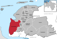  | ||
| Coordinates: 53°26′N 7°5′E / 53.433°N 7.083°ECoordinates: 53°26′N 7°5′E / 53.433°N 7.083°E | ||
| Country | Germany | |
| State | Lower Saxony | |
| District | Aurich | |
| Government | ||
| • Mayor | Johann Saathoff (SPD) | |
| Area | ||
| • Total | 159.2 km2 (61.5 sq mi) | |
| Elevation | 0 m (0 ft) | |
| Population (2017-12-31)[1] | ||
| • Total | 12,165 | |
| • Density | 76/km2 (200/sq mi) | |
| Time zone | CET/CEST (UTC+1/+2) | |
| Postal codes | 26736 | |
| Dialling codes | 04923, 04926, 04927 | |
| Vehicle registration | AUR | |
| Website | www.krummhoern.de | |
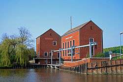
Krummhörn is a municipality in the district of Aurich, in Lower Saxony, Germany. It is situated near the Ems estuary, approximately 15 km southwest of Norden, and 10 km northwest of Emden.
The community (Gemeinde) of Krummhörn comprises 19 villages (population as of 31 December 2008):
|
|
Notable people
- Eggerik Beninga (1490–1562), a chronicler of the Frisians, was born in Grimersum.
References
| Wikimedia Commons has media related to Krummhörn. |
Towns and municipalities in Aurich (district) | ||
|---|---|---|
Villages in the municipality of Krummhörn | ||
|---|---|---|
 | ||
This article is issued from
Wikipedia.
The text is licensed under Creative Commons - Attribution - Sharealike.
Additional terms may apply for the media files.