Berumbur
| Berumbur | ||
|---|---|---|
| ||
 Berumbur Location of Berumbur within Aurich district 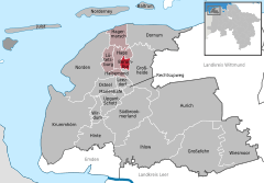  | ||
| Coordinates: 53°36′00″N 07°19′00″E / 53.60000°N 7.31667°ECoordinates: 53°36′00″N 07°19′00″E / 53.60000°N 7.31667°E | ||
| Country | Germany | |
| State | Lower Saxony | |
| District | Aurich | |
| Municipal assoc. | Hage | |
| Government | ||
| • Mayor | Cornelius Peters (SPD) | |
| Area | ||
| • Total | 6.42 km2 (2.48 sq mi) | |
| Elevation | 3 m (10 ft) | |
| Population (2017-12-31)[1] | ||
| • Total | 2,749 | |
| • Density | 430/km2 (1,100/sq mi) | |
| Time zone | CET/CEST (UTC+1/+2) | |
| Postal codes | 26524 | |
| Dialling codes | 0 49 36 | |
| Vehicle registration | AUR | |

Berumbur is a municipality in the district of Aurich, in Lower Saxony, Germany.
In 2004, the municipality had approximately 2,400 inhabitants and covers an area of 6.42 square kilometers.
The municipality includes the districts Berumbur, Berum, Small Heath, Wood Village and Blandorf.
There are many fishing lakes, two in Berumbur directly. The most famous lake is a great Kiessee, used for bathing (at one's own risk).
References
Towns and municipalities in Aurich (district) | ||
|---|---|---|
| Authority control |
|---|
This article is issued from
Wikipedia.
The text is licensed under Creative Commons - Attribution - Sharealike.
Additional terms may apply for the media files.