Kruklanki
| Kruklanki | |
|---|---|
| Village | |
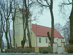 Assumption of Virgin Mary church | |
 Kruklanki | |
| Coordinates: 54°5′18″N 21°55′21″E / 54.08833°N 21.92250°ECoordinates: 54°5′18″N 21°55′21″E / 54.08833°N 21.92250°E | |
| Country |
|
| Voivodeship | Warmian-Masurian |
| County | Giżycko |
| Gmina | Kruklanki |
| Population | 1,100 |
| Website | http://www.kruklanki.pl |
Kruklanki [kruˈklanki] (German: Kruglanken)[1] is a village in Giżycko County, Warmian-Masurian Voivodeship, in northern Poland. It is the seat of the gmina (administrative district) called Gmina Kruklanki.[2] It lies approximately 12 kilometres (7 mi) north-east of Giżycko and 100 km (62 mi) east of the regional capital Olsztyn.
Before 1945 the area was part of Germany (East Prussia). After World War II the area was placed under Polish administration by the Potsdam Agreement under territorial changes demanded by the Soviet Union. Germans fled or were expelled and replaced with Poles expelled from the Polish areas annexed by the Soviet Union or forced to settle in the area through Operation Vistula in 1947.
The village has a population of 1,100.
References
- ↑ "Former Territory of Germany" (in German). 2017-11-09.
- ↑ "Central Statistical Office (GUS) - TERYT (National Register of Territorial Land Apportionment Journal)" (in Polish). 2008-06-01.
| Wikimedia Commons has media related to Kruklanki. |
| Seat |  | |
|---|---|---|
| Other villages | ||